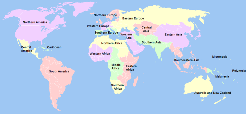
فائل:United Nations geographical subregions.png

ایس وکھالے دا ناپ: ۸۰۰ × ۳۷۰ پکسلز۔ دوجے ریزولوشنز: ۳۲۰ × ۱۴۸ پکسلز | ۶۴۰ × ۲۹۶ پکسلز | ۱,۳۵۷ × ۶۲۸ پکسلز ۔
اصل فائل (۱,۳۵۷ × ۶۲۸ پکسلز, فائل حجم: ۸۱ کلوبائٹ, MIME type: image/png)
فائل دی تریخ
فائل نو اس ویلے دی حالت وچ ویکھن واسطے تاریخ/ویلے تے کلک کرو۔
| تریخ تے ویلہ | نکی مورت | پاسے | ورتن والا | تیپّݨی کرو | |
|---|---|---|---|---|---|
| موجودہ | ۰۸:۲۰, ۲۱ دسمبر ۲۰۱۲ |  | ۱,۳۵۷ × ۶۲۸ (۸۱ کلوبائٹ) | Spacepotato | Revert to the version of 14 Jan, since in the current version of the UN geographic classification scheme, http://unstats.un.org/unsd/methods/m49/m49regin.htm , South Sudan has been placed in Eastern Africa. |
| ۱۳:۳۶, ۲۴ جنوری ۲۰۱۲ |  | ۱,۳۵۷ × ۶۲۸ (۶۰ کلوبائٹ) | Quintucket | Does it make sense to include South Sudan in East Africa? Yes. Does the United Nations usually do things on the ground that they make sense? No. For now, at least South Sudan is "North Africa" as far as the UN is concerned. | |
| ۲۰:۲۷, ۱۴ جنوری ۲۰۱۲ |  | ۱,۳۵۷ × ۶۲۸ (۸۱ کلوبائٹ) | Дмитрий-5-Аверин | Южный Судан | |
| ۰۷:۱۵, ۱۷ فروری ۲۰۱۰ |  | ۱,۳۵۷ × ۶۲۸ (۸۱ کلوبائٹ) | Stevanb | I don't see any reason why Kosovo should be listed here because it is not UN recognized country and this is UN geoscheme. | |
| ۲۲:۲۱, ۱۵ فروری ۲۰۱۰ |  | ۱,۳۵۷ × ۶۲۸ (۶۳ کلوبائٹ) | Dwo | Reverted to version as of 14:34, 18 October 2008 | |
| ۲۳:۱۵, ۶ دسمبر ۲۰۰۹ |  | ۱,۳۵۷ × ۶۲۸ (۶۳ کلوبائٹ) | Keepscases | Reverted to version as of 03:00, 3 July 2006 | |
| ۱۹:۳۴, ۱۸ اکتوبر ۲۰۰۸ |  | ۱,۳۵۷ × ۶۲۸ (۶۳ کلوبائٹ) | IJA | + Montenegro as UN member. | |
| ۰۵:۱۹, ۷ دسمبر ۲۰۰۶ |  | ۱,۳۵۷ × ۶۲۸ (۵۶ کلوبائٹ) | Psychlopaedist | Reverted to earlier revision | |
| ۰۵:۱۸, ۷ دسمبر ۲۰۰۶ |  | ۱,۳۵۷ × ۶۲۸ (۵۶ کلوبائٹ) | Psychlopaedist | Reverted to earlier revision | |
| ۰۸:۰۰, ۳ جولائی ۲۰۰۶ |  | ۱,۳۵۷ × ۶۲۸ (۶۳ کلوبائٹ) | Mexicano~commonswiki | This image was copied from wikipedia:en. The original description was: == Summary == Created by User:Ben Arnold, edited by User:E Pluribus Anthony, from Image:BlankMap-World.png. Information about geographical subregions was obtained from ht |
فائل دی ورتوں
تھلے دتے گئے 2 صفحے اس فائل نال جُڑدے نیں
فائل ویاپک ورتوں
ایہہ دوجے وکیاں ایس فائل نوں ورتدے نیں –
- an.wikipedia.org تے ورتوں
- ar.wikipedia.org تے ورتوں
- az.wikipedia.org تے ورتوں
- ban.wikipedia.org تے ورتوں
- bbc.wikipedia.org تے ورتوں
- bg.wikipedia.org تے ورتوں
- bn.wikipedia.org تے ورتوں
- ckb.wikipedia.org تے ورتوں
- da.wikipedia.org تے ورتوں
- en.wikipedia.org تے ورتوں
- Talk:Melanesia
- Talk:Southern Europe
- Subregion
- User:Big Adamsky
- Wikipedia talk:WikiProject Aviation/Airline destination lists
- User:Nightstallion/sandbox
- Talk:Oceania/Archive 2
- User:Lilliputian/navel ring
- User:Nurg/Continent
- United Nations geoscheme
- Talk:List of European tornadoes and tornado outbreaks
- Talk:Asian Americans/Archive 2
- User:Patrick/Asia
- Talk:2007 FIBA Americas Championship
- Talk:Ethnic groups in Europe/Archive 1
- Wikipedia talk:WikiProject International relations/Archive 2
- List of countries by population (United Nations)
- User:DexDor/Categorization of organisms by geography
- Talk:West Asia/Archive 1
- es.wikipedia.org تے ورتوں
- et.wikipedia.org تے ورتوں
- fr.wikipedia.org تے ورتوں
- hy.wikipedia.org تے ورتوں
- it.wikipedia.org تے ورتوں
ایس فائل دا ویکھو ہور جگت ورتن .


