فائل:Syrdaryamap.png
ایس وکھالے دا ناپ: ۷۱۹ × ۶۰۰ پکسلز۔ دوجے ریزولوشنز: ۲۸۸ × ۲۴۰ پکسلز | ۵۷۶ × ۴۸۰ پکسلز | ۸۲۰ × ۶۸۴ پکسلز ۔
اصل فائل (۸۲۰ × ۶۸۴ پکسلز, فائل حجم: ۹۳۶ کلوبائٹ, MIME type: image/png)
خلاصہ

|
This map image could be re-created using vector graphics as an SVG file. This has several advantages; see Commons:Media for cleanup for more information. If an SVG form of this image is available, please upload it and afterwards replace this template with
{{vector version available|new image name}}.
It is recommended to name the SVG file “Syrdaryamap.svg”—then the template Vector version available (or Vva) does not need the new image name parameter. |
| تفصیل |
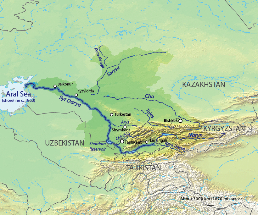
English: Map of the Syr Darya Basin watershed, of the Syr Darya and Chu Rivers — in Central Asia.
Қазақша: Сырдария
Татарча / tatarça: Сырдәрья |
| تریخ | to 06 |
| سروت | Background and river course data from http://www2.demis.nl/mapserver/mapper.asp |
| لکھاری | Background layer attributed to DEMIS Mapserver, map created by Shannon1 |
| اجازت (فائل نوں دوبارہ ورتنا) |
Map created from DEMIS Mapserver, which are public domain. |
| دوجے ورژن |
Derivative works of this file: |
لائسنس –
میں، اس کم دے کاپیرائٹ دا مالک، اس کم نوں اس لائسنس دے مطابق چھاپدا واں:

|
کاپی کرن، ونڈن تے بدلن دی ایس ڈوکومنٹ لئی اجازت دتی جاندی اے ایہناں GNU Free Documentation License, Version 1.2 شرطاں نال یا مگروں کسے وی چھپے ورین Free Software Foundation توں بنا کسے انویرینٹ سیکشن دے، ناں فرنٹ کور لکھت تے ناں بیک کور لکھت دے۔ لسنس دی اک کاپی سیکشن وچ ہیگی اے جہدا ناں اے GNU Free Documentation License۔ |
This file is licensed under the Creative Commons Attribution-Share Alike 4.0 International, 3.0 Unported, 2.5 Generic, 2.0 Generic and 1.0 Generic license.
- تہانوں کھلھ اے:
- حصہ کرنا – کاپی، ونڈنا تے کم بھیجنا
- فیر رلانا – کم نوں فٹ کرنا
- تھلے دتیاں شرطاں نال:
- کس دے ناں – تسیں لازمی ایس کم دے بناں والے بارے دسو جنج اونے آکھیا اے یا جنج لسنس چ آکھیا گیا ہے۔
- اکو جہا شئیر کرو۔ – اگر تسیں بدلدے یا ایس کم تے بناندے تے بنن والے کم نوں اینج دے لسنس نال ای ونڈو گے۔
تسیں اپنی مرضی دا لائسنس چݨ سکدے اوہ۔
فائل دی تریخ
فائل نو اس ویلے دی حالت وچ ویکھن واسطے تاریخ/ویلے تے کلک کرو۔
| تریخ تے ویلہ | نکی مورت | پاسے | ورتن والا | تیپّݨی کرو | |
|---|---|---|---|---|---|
| موجودہ | ۰۸:۱۱, ۱۸ اکتوبر ۲۰۱۳ | | ۸۲۰ × ۶۸۴ (۹۳۶ کلوبائٹ) | Shannon1 | redrew and fixed watershed boundary |
| ۱۴:۲۱, ۸ جنوری ۲۰۱۱ |  | ۱,۱۰۱ × ۸۶۶ (۱.۶۵ میگابائٹ) | Sibom | chu | |
| ۱۴:۲۰, ۸ جنوری ۲۰۱۱ |  | ۱,۱۰۱ × ۸۶۶ (۱.۶۵ میگابائٹ) | Sibom | чу | |
| ۰۸:۰۴, ۷ فروری ۲۰۱۰ |  | ۱,۱۰۱ × ۸۶۶ (۱.۵۱ میگابائٹ) | Shannon1 | {{Information |Description={{en|1=Map of the watershed of the Syr Darya in Central Asia, that drains to the Aral Sea.}} |Source=Background and river course data from http://www2.demis.nl/mapserver/mapper.asp |Author=Background layer attributed to DEMIS M |
فائل دی ورتوں
تھلے دتے گئے 2 صفحے اس فائل نال جُڑدے نیں
فائل ویاپک ورتوں
ایہہ دوجے وکیاں ایس فائل نوں ورتدے نیں –
- af.wikipedia.org تے ورتوں
- ar.wikipedia.org تے ورتوں
- ast.wikipedia.org تے ورتوں
- bg.wikipedia.org تے ورتوں
- bh.wikipedia.org تے ورتوں
- bn.wikipedia.org تے ورتوں
- cs.wikipedia.org تے ورتوں
- cv.wikipedia.org تے ورتوں
- da.wikipedia.org تے ورتوں
- de.wikipedia.org تے ورتوں
- en.wikipedia.org تے ورتوں
- es.wikipedia.org تے ورتوں
- et.wikipedia.org تے ورتوں
- fi.wikipedia.org تے ورتوں
- fr.wikipedia.org تے ورتوں
- he.wikipedia.org تے ورتوں
- hi.wikipedia.org تے ورتوں
- hr.wikipedia.org تے ورتوں
- hu.wikipedia.org تے ورتوں
- hy.wikipedia.org تے ورتوں
- id.wikipedia.org تے ورتوں
ایس فائل دا ویکھو ہور جگت ورتن .