فائل:Suez canal map.jpg
اس توں وڈی مورت موجود نہیں۔
Suez_canal_map.jpg (۵۰۰ × ۵۸۲ پکسلز, فائل حجم: ۱۰۷ کلوبائٹ, MIME type: image/jpeg)
خلاصہ
| تفصیل |
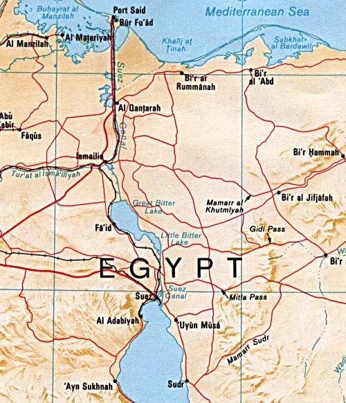
English: Map of the Suez canal extracted from a map of the Sinai Peninsula. |
| تریخ | |
| سروت |
University of Texas Libraries, Perry-Castañeda Library Map Collection: Egypt Maps, Egypt - Sinai Peninsula (Shaded Relief) 1992 |
| لکھاری | CIA |
| دوجے ورژن | , Arabic Derivative |

لائسنس –
| This image is a work of a Central Intelligence Agency employee, taken or made as part of that person's official duties. As a Work of the United States Government, this image or media is in the public domain in the United States.
|

|
| Annotations | This image is annotated: View the annotations at Commons |
فائل دی تریخ
فائل نو اس ویلے دی حالت وچ ویکھن واسطے تاریخ/ویلے تے کلک کرو۔
| تریخ تے ویلہ | نکی مورت | پاسے | ورتن والا | تیپّݨی کرو | |
|---|---|---|---|---|---|
| موجودہ | ۰۱:۰۴, ۳۰ مئی ۲۰۰۷ | | ۵۰۰ × ۵۸۲ (۱۰۷ کلوبائٹ) | Orlovic | Cropped from here: http://commons.wikimedia.org/wiki/Image:Sinai-peninsula-map.jpg Category:Suez Canal |
فائل دی ورتوں
تھلے دتے گئے 1 صفحے اس فائل نال جُڑدے نیں
فائل ویاپک ورتوں
ایہہ دوجے وکیاں ایس فائل نوں ورتدے نیں –
- af.wikipedia.org تے ورتوں
- ar.wikipedia.org تے ورتوں
- arz.wikipedia.org تے ورتوں
- ast.wikipedia.org تے ورتوں
- azb.wikipedia.org تے ورتوں
- az.wikipedia.org تے ورتوں
- bn.wikipedia.org تے ورتوں
- ca.wikipedia.org تے ورتوں
- cs.wikipedia.org تے ورتوں
- cy.wikipedia.org تے ورتوں
- da.wikipedia.org تے ورتوں
- de.wikipedia.org تے ورتوں
- en.wikipedia.org تے ورتوں
- es.wikipedia.org تے ورتوں
- eu.wikipedia.org تے ورتوں
- fa.wikipedia.org تے ورتوں
- fi.wikipedia.org تے ورتوں
- fr.wikipedia.org تے ورتوں
- he.wikipedia.org تے ورتوں
- id.wikipedia.org تے ورتوں
- it.wikipedia.org تے ورتوں
- ja.wikipedia.org تے ورتوں
- nl.wikipedia.org تے ورتوں
- no.wikipedia.org تے ورتوں
- pl.wiktionary.org تے ورتوں
- pt.wikipedia.org تے ورتوں
- ro.wikipedia.org تے ورتوں
- ru.wikipedia.org تے ورتوں
- sh.wikipedia.org تے ورتوں
- simple.wikipedia.org تے ورتوں
- sk.wikipedia.org تے ورتوں
- sq.wikipedia.org تے ورتوں
- sr.wikipedia.org تے ورتوں
- sv.wikipedia.org تے ورتوں
- ta.wikipedia.org تے ورتوں
- tr.wikipedia.org تے ورتوں
ایس فائل دا ویکھو ہور جگت ورتن .