فائل:South America southern tip pol.png

ایس وکھالے دا ناپ: ۸۰۰ × ۴۹۴ پکسلز۔ دوجے ریزولوشنز: ۳۲۰ × ۱۹۸ پکسلز | ۶۴۰ × ۳۹۵ پکسلز | ۱,۰۲۴ × ۶۳۲ پکسلز | ۱,۲۸۰ × ۷۹۰ پکسلز | ۲,۵۶۰ × ۱,۵۸۱ پکسلز | ۳,۸۵۹ × ۲,۳۸۳ پکسلز ۔
اصل فائل (۳,۸۵۹ × ۲,۳۸۳ پکسلز, فائل حجم: ۵۹۶ کلوبائٹ, MIME type: image/png)
خلاصہ
| تفصیل |
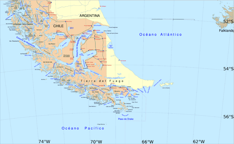
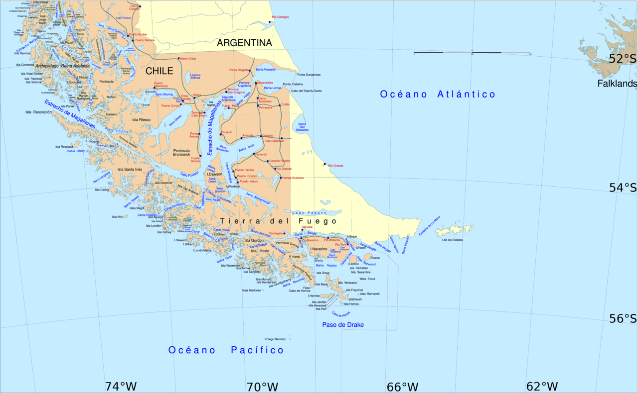
English: Political map of southern Chile and Argentina, from Straits of Magellan to Cape Horn.
Español: Mapa político del sur de Chile y la Argentina, entre el estrecho de Magallanes y el cabo de Hornos. |
||||
| تریخ | |||||
| سروت | File:Sur2.gif | ||||
| لکھاری | User:Createaccount | ||||
| اجازت (فائل نوں دوبارہ ورتنا) |
|
||||
| دوجے ورژن | Derivative works of this file: Metula.svg |
لائسنس –

|
کاپی کرن، ونڈن تے بدلن دی ایس ڈوکومنٹ لئی اجازت دتی جاندی اے ایہناں GNU Free Documentation License, Version 1.2 شرطاں نال یا مگروں کسے وی چھپے ورین Free Software Foundation توں بنا کسے انویرینٹ سیکشن دے، ناں فرنٹ کور لکھت تے ناں بیک کور لکھت دے۔ لسنس دی اک کاپی سیکشن وچ ہیگی اے جہدا ناں اے GNU Free Documentation License۔ |
| ایس فائل نوں کریٹو کامنز Attribution 2.5 پولینڈ لائسنس دتا گیا. | ||
| ||
| اس لائسنس دا ٹیگ GFDL دے مطابق اس فائل چ پایا گیا اے licensing update۔ |
فائل دی تریخ
فائل نو اس ویلے دی حالت وچ ویکھن واسطے تاریخ/ویلے تے کلک کرو۔
| تریخ تے ویلہ | نکی مورت | پاسے | ورتن والا | تیپّݨی کرو | |
|---|---|---|---|---|---|
| موجودہ | ۱۹:۰۶, ۳۰ اپریل ۲۰۱۶ | | ۳,۸۵۹ × ۲,۳۸۳ (۵۹۶ کلوبائٹ) | Hohum | Cartographic colours |
| ۱۶:۰۹, ۳ اپریل ۲۰۱۳ |  | ۳,۸۵۹ × ۲,۳۸۳ (۵۹۷ کلوبائٹ) | Keysanger | Margin right and top cropped | |
| ۱۵:۴۷, ۳ اپریل ۲۰۱۳ |  | ۳,۸۵۹ × ۲,۳۸۳ (۵۹۷ کلوبائٹ) | Keysanger | "Estrecho Nelson" added Bigger Latitude and Longitude within the image empty margin cropped | |
| ۰۰:۳۰, ۴ مئی ۲۰۰۹ |  | ۳,۸۹۴ × ۲,۴۴۱ (۶۳۹ کلوبائٹ) | Pitichinaccio | different colour | |
| ۰۰:۲۹, ۴ مئی ۲۰۰۹ |  | ۳,۸۹۴ × ۲,۴۴۱ (۶۳۹ کلوبائٹ) | Pitichinaccio | {{Information |Description={{en|1=political map of southern Chile/Argentina: From Straits of Magellan to Cape Horn}} |Source=File:Sur2.gif |Author=User:Createaccount |Date=2008 |Permission={{GFDL-GMT}}} |other_versions=File:Sur2.gif }} <!-- |
فائل دی ورتوں
تھلے دتے گئے 1 صفحے اس فائل نال جُڑدے نیں
فائل ویاپک ورتوں
ایہہ دوجے وکیاں ایس فائل نوں ورتدے نیں –
- af.wikipedia.org تے ورتوں
- als.wikipedia.org تے ورتوں
- ar.wikipedia.org تے ورتوں
- ast.wikipedia.org تے ورتوں
- br.wikipedia.org تے ورتوں
- ca.wikipedia.org تے ورتوں
- de.wikipedia.org تے ورتوں
- de.wiktionary.org تے ورتوں
- el.wikipedia.org تے ورتوں
- en.wikipedia.org تے ورتوں
- Cape Froward
- Porvenir, Chile
- Santa Inés Island
- Puerto Toro
- False Cape Horn
- Puerto del Hambre
- Maritime history of California
- Brunswick Peninsula
- Almirantazgo Fjord
- Fjord of the Mountains
- Primera Angostura
- Aracena Island
- Punta Dúngeness
- Muñoz Gamero Peninsula
- Seno Otway
- Mitre Peninsula
- Marlborough (1876 ship)
ایس فائل دا ویکھو ہور جگت ورتن .