فائل:South-east frontier of France after the Treaty of Paris, 1814.jpg

ایس وکھالے دا ناپ: ۴۶۸ × ۶۰۰ پکسلز۔ دوجے ریزولوشنز: ۱۸۷ × ۲۴۰ پکسلز | ۳۷۴ × ۴۸۰ پکسلز | ۵۹۹ × ۷۶۸ پکسلز | ۷۹۹ × ۱,۰۲۴ پکسلز | ۱,۶۴۸ × ۲,۱۱۲ پکسلز ۔
اصل فائل (۱,۶۴۸ × ۲,۱۱۲ پکسلز, فائل حجم: ۱.۷۱ میگابائٹ, MIME type: image/jpeg)
خلاصہ
| تفصیل |
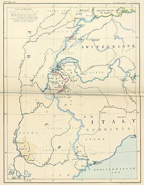
English: South-east frontier of France after the Treaty of Paris, 1814 |
| تریخ | |
| سروت | Edward Hertslet (1875). The map of Europe by treaty; showing the various political and territorial changes which have taken place since the general peace of 1814, London, Butterworths. p. opposite 28, 351 |
| لکھاری | Edward Hertslet; and Stafford's Geng Estab, 55 Charing Cross |
لائسنس –
|
This work is in the public domain in its country of origin and other countries and areas where the copyright term is the author's life plus 70 years or fewer. This work is in the public domain in the United States because it was published (or registered with the U.S. Copyright Office) before January 1, 1929. | |
| ایہ فائل دے بارے چ دس اے جے اے کاپی حف دیاں روکاں توں کھلی اے تے نالدے رلدے حقاں توں وی۔ | |
فائل دی تریخ
فائل نو اس ویلے دی حالت وچ ویکھن واسطے تاریخ/ویلے تے کلک کرو۔
| تریخ تے ویلہ | نکی مورت | پاسے | ورتن والا | تیپّݨی کرو | |
|---|---|---|---|---|---|
| موجودہ | ۰۲:۳۱, ۴ ستمبر ۲۰۱۴ | | ۱,۶۴۸ × ۲,۱۱۲ (۱.۷۱ میگابائٹ) | PBS | User created page with UploadWizard |
فائل دی ورتوں
تھلے دتے گئے 1 صفحے اس فائل نال جُڑدے نیں
فائل ویاپک ورتوں
ایہہ دوجے وکیاں ایس فائل نوں ورتدے نیں –
- ar.wikipedia.org تے ورتوں
- en.wikipedia.org تے ورتوں
- es.wikipedia.org تے ورتوں
- fr.wikipedia.org تے ورتوں
- he.wikipedia.org تے ورتوں
- it.wikipedia.org تے ورتوں
- ja.wikipedia.org تے ورتوں
- ka.wikipedia.org تے ورتوں
- pt.wikipedia.org تے ورتوں
- pt.wikiquote.org تے ورتوں
- sr.wikipedia.org تے ورتوں
- tt.wikipedia.org تے ورتوں
- uk.wikipedia.org تے ورتوں
- ur.wikipedia.org تے ورتوں