فائل:Rom1793-1812.png
اس توں وڈی مورت موجود نہیں۔
Rom1793-1812.png (۵۸۷ × ۴۱۳ پکسلز, فائل حجم: ۷۸ کلوبائٹ, MIME type: image/png)


|
This map image could be re-created using vector graphics as an SVG file. This has several advantages; see Commons:Media for cleanup for more information. If an SVG form of this image is available, please upload it and afterwards replace this template with
{{vector version available|new image name}}.
It is recommended to name the SVG file “Rom1793-1812.svg”—then the template Vector version available (or Vva) does not need the new image name parameter. |
خلاصہ
| تفصیل |
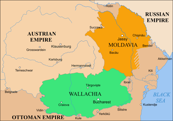
English: Moldavia, Wallachia and Transylvania between the Second Partition of Poland, 1793 and the Treaty of Bucharest, 1812 |
| سروت | |
| لکھاری |
لائسنس –
| ایس فائل نوں کریٹو کامنز Attribution 2.5 پولینڈ لائسنس دتا گیا. Subject to disclaimers. | ||
| ||
| اس لائسنس دا ٹیگ GFDL دے مطابق اس فائل چ پایا گیا اے licensing update۔ |

|
کاپی کرن، ونڈن تے بدلن دی ایس ڈوکومنٹ لئی اجازت دتی جاندی اے ایہناں GNU Free Documentation License, Version 1.2 شرطاں نال یا مگروں کسے وی چھپے ورین Free Software Foundation توں بنا کسے انویرینٹ سیکشن دے، ناں فرنٹ کور لکھت تے ناں بیک کور لکھت دے۔ لسنس دی اک کاپی سیکشن وچ ہیگی اے جہدا ناں اے GNU Free Documentation License۔ Subject to disclaimers. |

|
File:Danubian Principalities 1800.svg is a vector version of this file. It should be used in place of this PNG file when not inferior.
File:Rom1793-1812.png → File:Danubian Principalities 1800.svg
For more information, see Help:SVG. |
 |
فائل دی تریخ
فائل نو اس ویلے دی حالت وچ ویکھن واسطے تاریخ/ویلے تے کلک کرو۔
| تریخ تے ویلہ | نکی مورت | پاسے | ورتن والا | تیپّݨی کرو | |
|---|---|---|---|---|---|
| موجودہ | ۱۷:۴۹, ۸ اکتوبر ۲۰۲۳ | | ۵۸۷ × ۴۱۳ (۷۸ کلوبائٹ) | Gyalu22 | Transylvania was part of the Austrian Empire |
| ۲۱:۵۷, ۱۵ فروری ۲۰۱۹ |  | ۵۸۷ × ۴۱۳ (۹۱ کلوبائٹ) | Anonimu | Reverted to version as of 10:18, 2 November 2018 (UTC) | |
| ۲۲:۱۳, ۱۳ فروری ۲۰۱۹ |  | ۵۸۷ × ۴۱۳ (۱۰۶ کلوبائٹ) | Julieta39 | Since the maps of this time | |
| ۱۵:۱۸, ۲ نومبر ۲۰۱۸ |  | ۵۸۷ × ۴۱۳ (۹۱ کلوبائٹ) | Anonimu | too much detail distract from subject. also,18th century maps are not generally accurate fo the region | |
| ۱۹:۵۸, ۱۹ اکتوبر ۲۰۱۸ |  | ۵۸۷ × ۴۱۳ (۱۱۳ کلوبائٹ) | Claude Zygiel | More details since 18th century maps | |
| ۰۴:۲۶, ۱۲ جولائی ۲۰۱۸ |  | ۵۸۷ × ۴۱۳ (۹۱ کلوبائٹ) | Anonimu | more accurate borders | |
| ۲۲:۲۲, ۸ نومبر ۲۰۱۵ |  | ۵۸۸ × ۴۱۳ (۸۹ کلوبائٹ) | Spiridon Ion Cepleanu | Colours | |
| ۰۲:۰۵, ۲۲ فروری ۲۰۱۰ |  | ۵۸۸ × ۴۱۳ (۵۱ کلوبائٹ) | Olahus | Corrections on the borders to the Ottoman Empire. | |
| ۰۲:۰۱, ۲۰ مئی ۲۰۰۶ |  | ۵۸۸ × ۴۱۳ (۲۹ کلوبائٹ) | Zserghei | This image was copied from wikipedia:en. The original description was: == Summary == Moldavia, Wallachia and Transylvania between the Second Partition of Poland, 1793 and the Treaty of Bucharest, 1812 == Licensing == {{GFDL-self}} [[Category:Romania his | |
| ۱۴:۱۵, ۹ اپریل ۲۰۰۶ |  | ۵۸۸ × ۴۱۳ (۲۹ کلوبائٹ) | Daos~commonswiki | Moldavia, Wallachia and Transylvania between the Second Partition of Poland, 1793 and the Treaty of Bucharest, 1812 |
فائل دی ورتوں
تھلے دتے گئے 3 صفحے اس فائل نال جُڑدے نیں
فائل ویاپک ورتوں
ایہہ دوجے وکیاں ایس فائل نوں ورتدے نیں –
- ar.wikipedia.org تے ورتوں
- azb.wikipedia.org تے ورتوں
- be-tarask.wikipedia.org تے ورتوں
- ca.wikipedia.org تے ورتوں
- cs.wikipedia.org تے ورتوں
- da.wikipedia.org تے ورتوں
- de.wikipedia.org تے ورتوں
- el.wikipedia.org تے ورتوں
- en.wikipedia.org تے ورتوں
- es.wikipedia.org تے ورتوں
- et.wikipedia.org تے ورتوں
- fr.wikipedia.org تے ورتوں
- gl.wikipedia.org تے ورتوں
- he.wikipedia.org تے ورتوں
- hu.wikipedia.org تے ورتوں
- io.wikipedia.org تے ورتوں
- it.wikipedia.org تے ورتوں
- ja.wikipedia.org تے ورتوں
- la.wikipedia.org تے ورتوں
- lt.wikipedia.org تے ورتوں
- mt.wikipedia.org تے ورتوں
- pt.wikipedia.org تے ورتوں
- ro.wikipedia.org تے ورتوں
- ru.wikipedia.org تے ورتوں
ایس فائل دا ویکھو ہور جگت ورتن .