فائل:RedFortAgra-Map-20080211.jpg
ایس وکھالے دا ناپ: ۷۴۴ × ۶۰۰ پکسلز۔ دوجے ریزولوشنز: ۲۹۸ × ۲۴۰ پکسلز | ۵۹۵ × ۴۸۰ پکسلز | ۹۵۳ × ۷۶۸ پکسلز | ۱,۲۷۰ × ۱,۰۲۴ پکسلز | ۲,۵۴۰ × ۲,۰۴۸ پکسلز | ۳,۲۶۴ × ۲,۶۳۲ پکسلز ۔
اصل فائل (۳,۲۶۴ × ۲,۶۳۲ پکسلز, فائل حجم: ۱.۶ میگابائٹ, MIME type: image/jpeg)

|
This architecture image could be re-created using vector graphics as an SVG file. This has several advantages; see Commons:Media for cleanup for more information. If an SVG form of this image is available, please upload it and afterwards replace this template with
{{vector version available|new image name}}.
It is recommended to name the SVG file “RedFortAgra-Map-20080211.svg”—then the template Vector version available (or Vva) does not need the new image name parameter. |


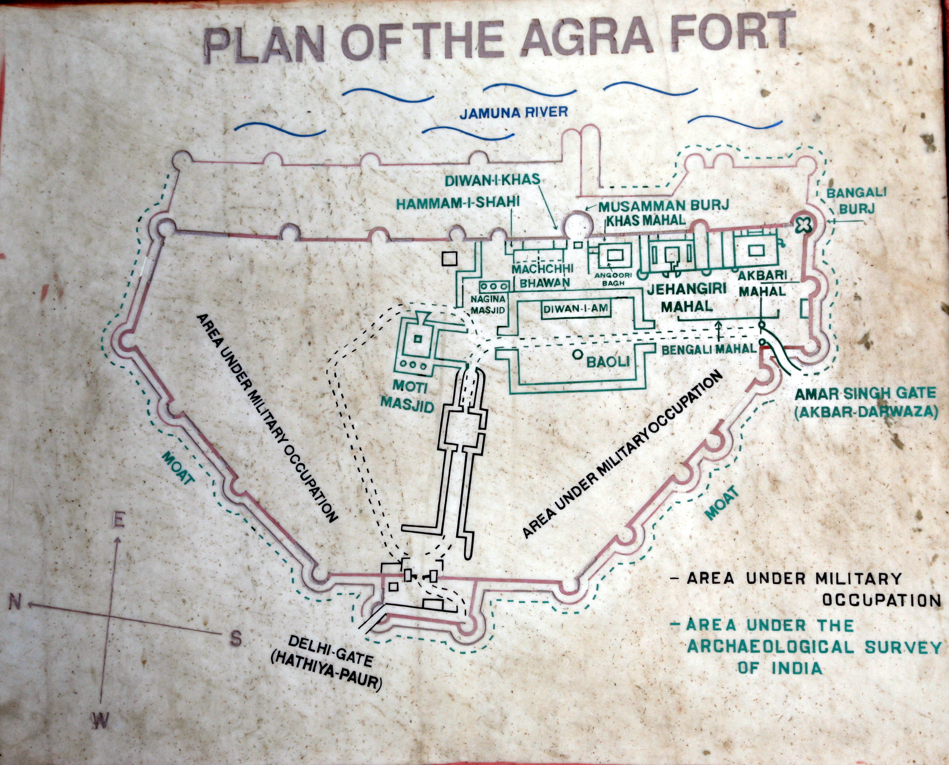
| تفصیل | Map of the Red Fort Agra |
| تریخ | |
| سروت | آپݨا کم |
| لکھاری | Hans A. Rosbach |
میں، اس کم دے کاپیرائٹ دا مالک، اس کم نوں اس لائسنس دے مطابق چھاپدا واں:
ایس فائل نوں کریٹو کامنز Attribution 2.5 پولینڈ لائسنس دتا گیا.
- تہانوں کھلھ اے:
- حصہ کرنا – کاپی، ونڈنا تے کم بھیجنا
- فیر رلانا – کم نوں فٹ کرنا
- تھلے دتیاں شرطاں نال:
- کس دے ناں – تسیں لازمی ایس کم دے بناں والے بارے دسو جنج اونے آکھیا اے یا جنج لسنس چ آکھیا گیا ہے۔
- اکو جہا شئیر کرو۔ – اگر تسیں بدلدے یا ایس کم تے بناندے تے بنن والے کم نوں اینج دے لسنس نال ای ونڈو گے۔
| Camera location | | View this and other nearby images on: OpenStreetMap |
|---|
فائل دی تریخ
فائل نو اس ویلے دی حالت وچ ویکھن واسطے تاریخ/ویلے تے کلک کرو۔
| تریخ تے ویلہ | نکی مورت | پاسے | ورتن والا | تیپّݨی کرو | |
|---|---|---|---|---|---|
| موجودہ | ۱۶:۵۷, ۲ اکتوبر ۲۰۱۰ | | ۳,۲۶۴ × ۲,۶۳۲ (۱.۶ میگابائٹ) | Vssun | cropped and white balanced |
| ۰۲:۲۶, ۷ مارچ ۲۰۰۸ |  | ۴,۳۶۸ × ۲,۹۱۲ (۱.۹ میگابائٹ) | Haros | {{Information |Description=Map of the Red Fort Agra |Source=own work |Date=2008-02-11 |Author=Hans A. Rosbach |Permission=Own work, share alike, attribution required (Creative Commons CC-BY-SA-3.0) |other_versions= }} {{self|cc-by-sa-3.0}} [[Category:Fo |
فائل دی ورتوں
تھلے دتے گئے 1 صفحے اس فائل نال جُڑدے نیں
فائل ویاپک ورتوں
ایہہ دوجے وکیاں ایس فائل نوں ورتدے نیں –
- ca.wikipedia.org تے ورتوں
- de.wikipedia.org تے ورتوں
- fr.wikivoyage.org تے ورتوں
- hr.wikipedia.org تے ورتوں
- it.wikipedia.org تے ورتوں
- ml.wikipedia.org تے ورتوں
- pa.wikipedia.org تے ورتوں
- ps.wikipedia.org تے ورتوں
- sh.wikipedia.org تے ورتوں
- sq.wikipedia.org تے ورتوں
- ur.wikipedia.org تے ورتوں