فائل:Punjab district map.png

ایس وکھالے دا ناپ: ۵۴۰ × ۶۰۰ پکسلز۔ دوجے ریزولوشنز: ۲۱۶ × ۲۴۰ پکسلز | ۴۳۲ × ۴۸۰ پکسلز | ۶۹۱ × ۷۶۸ پکسلز | ۹۲۲ × ۱,۰۲۴ پکسلز | ۲,۴۶۷ × ۲,۷۴۱ پکسلز ۔
اصل فائل (۲,۴۶۷ × ۲,۷۴۱ پکسلز, فائل حجم: ۶۳۵ کلوبائٹ, MIME type: image/png)

|
This locator map image could be re-created using vector graphics as an SVG file. This has several advantages; see Commons:Media for cleanup for more information. If an SVG form of this image is available, please upload it and afterwards replace this template with
{{vector version available|new image name}}.
It is recommended to name the SVG file “Punjab district map.svg”—then the template Vector version available (or Vva) does not need the new image name parameter. |
خلاصہ
| تفصیل |
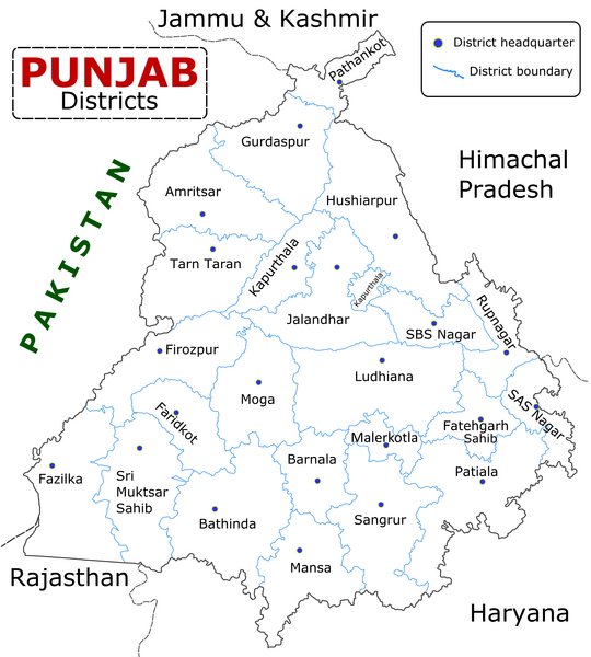
English: State of Punjab (Indian Punjab) with districts marked along with district Headquarters. |
| تریخ | |
| سروت | Self made using Inkscape. Source map referred from Punjab govt. site. |
| لکھاری | Wikigringo |
لائسنس –
میں، اس کم دے کاپیرائٹ دا مالک، اس کم نوں اس لائسنس دے مطابق چھاپدا واں:

|
کاپی کرن، ونڈن تے بدلن دی ایس ڈوکومنٹ لئی اجازت دتی جاندی اے ایہناں GNU Free Documentation License, Version 1.2 شرطاں نال یا مگروں کسے وی چھپے ورین Free Software Foundation توں بنا کسے انویرینٹ سیکشن دے، ناں فرنٹ کور لکھت تے ناں بیک کور لکھت دے۔ لسنس دی اک کاپی سیکشن وچ ہیگی اے جہدا ناں اے GNU Free Documentation License۔ |
This file is licensed under the Creative Commons Attribution-Share Alike 4.0 International, 3.0 Unported, 2.5 Generic, 2.0 Generic and 1.0 Generic license.
- تہانوں کھلھ اے:
- حصہ کرنا – کاپی، ونڈنا تے کم بھیجنا
- فیر رلانا – کم نوں فٹ کرنا
- تھلے دتیاں شرطاں نال:
- کس دے ناں – تسیں لازمی ایس کم دے بناں والے بارے دسو جنج اونے آکھیا اے یا جنج لسنس چ آکھیا گیا ہے۔
- اکو جہا شئیر کرو۔ – اگر تسیں بدلدے یا ایس کم تے بناندے تے بنن والے کم نوں اینج دے لسنس نال ای ونڈو گے۔
تسیں اپنی مرضی دا لائسنس چݨ سکدے اوہ۔
فائل دی تریخ
فائل نو اس ویلے دی حالت وچ ویکھن واسطے تاریخ/ویلے تے کلک کرو۔
| تریخ تے ویلہ | نکی مورت | پاسے | ورتن والا | تیپّݨی کرو | |
|---|---|---|---|---|---|
| موجودہ | ۱۴:۲۵, ۱۰ جنوری ۲۰۲۳ | | ۲,۴۶۷ × ۲,۷۴۱ (۶۳۵ کلوبائٹ) | Saad Ali Khan Pakistan | updated district MalerKotla on map |
| ۰۹:۴۵, ۷ جولائی ۲۰۲۰ |  | ۲,۴۶۷ × ۲,۷۴۱ (۸۶۷ کلوبائٹ) | Kaushal Bishnoi | New Update version of Punjab District Map with 22 District. | |
| ۱۹:۴۱, ۵ اکتوبر ۲۰۱۳ |  | ۱,۰۹۴ × ۸۴۸ (۱۲۷ کلوبائٹ) | Ras67 | cropped and optimized | |
| ۱۳:۴۰, ۲۸ اپریل ۲۰۰۸ |  | ۱,۲۱۱ × ۸۷۴ (۱۸۷ کلوبائٹ) | Wikigringo | Uploading a better color version of the file with bigger font size. | |
| ۲۱:۰۱, ۲۶ اپریل ۲۰۰۸ |  | ۱,۲۶۹ × ۹۰۷ (۱۶۷ کلوبائٹ) | Wikigringo | {{Information |Description=State of Punjab, India with districts marked along with district HQ. |Source=Self made using Inkscape. Source map referred from Punjab govt. site. |Date=04/26/2008 |Author=Wikigringo |Permission= |other_versions= }} |
فائل دی ورتوں
تھلے دتے گئے 6 صفحے اس فائل نال جُڑدے نیں
فائل ویاپک ورتوں
ایہہ دوجے وکیاں ایس فائل نوں ورتدے نیں –
- ar.wikipedia.org تے ورتوں
- azb.wikipedia.org تے ورتوں
- bh.wikipedia.org تے ورتوں
- bn.wikipedia.org تے ورتوں
- ca.wikipedia.org تے ورتوں
- ceb.wikipedia.org تے ورتوں
- en.wikipedia.org تے ورتوں
- es.wikipedia.org تے ورتوں
- eu.wikipedia.org تے ورتوں
- fa.wikipedia.org تے ورتوں
- fi.wikipedia.org تے ورتوں
- fr.wikipedia.org تے ورتوں
- Pendjab (Inde)
- District de Barnala
- District de Faridkot
- District de Fatehgarh Sahib
- District de Fazilka
- District de Firozpur
- District de Gurdaspur
- District de Hoshiarpur
- District de Jalandhar
- District de Kapurthala
- District de Ludhiana
- District de Mansa (Penjab)
- District de Moga
- District de Mohali
- District de Muktsar
ایس فائل دا ویکھو ہور جگت ورتن .