فائل:Ph physical map.png
ایس وکھالے دا ناپ: ۳۸۲ × ۵۹۸ پکسلز۔ دوجے ریزولوشنز: ۱۵۳ × ۲۴۰ پکسلز | ۶۰۰ × ۹۴۰ پکسلز ۔
اصل فائل (۶۰۰ × ۹۴۰ پکسلز, فائل حجم: ۱۱۴ کلوبائٹ, MIME type: image/png)
خلاصہ
| تفصیل |
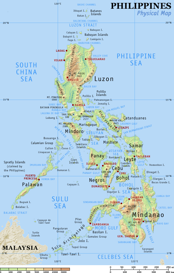
English: Physical map of the Philippines, showing all the major and some minor islands, bodies of water, mountains, and some major cities. |
| تریخ | |
| سروت | آپݨا کم |
| لکھاری | Eugene Alvin Villar (seav) |
| دوجے ورژن |
|


|

|
This map image could be re-created using vector graphics as an SVG file. This has several advantages; see Commons:Media for cleanup for more information. If an SVG form of this image is available, please upload it and afterwards replace this template with
{{vector version available|new image name}}.
It is recommended to name the SVG file “Ph physical map.svg”—then the template Vector version available (or Vva) does not need the new image name parameter. |
لائسنس –
میں، اس کم دے کاپیرائٹ دا مالک، اس کم نوں اس لائسنس دے مطابق چھاپدا واں:
This file is licensed under the Creative Commons Attribution-Share Alike 4.0 International license.
- تہانوں کھلھ اے:
- حصہ کرنا – کاپی، ونڈنا تے کم بھیجنا
- فیر رلانا – کم نوں فٹ کرنا
- تھلے دتیاں شرطاں نال:
- کس دے ناں – تسیں لازمی ایس کم دے بناں والے بارے دسو جنج اونے آکھیا اے یا جنج لسنس چ آکھیا گیا ہے۔
- اکو جہا شئیر کرو۔ – اگر تسیں بدلدے یا ایس کم تے بناندے تے بنن والے کم نوں اینج دے لسنس نال ای ونڈو گے۔
ایس فائل نوں کریٹو کامنز Attribution 2.5 پولینڈ لائسنس دتا گیا.
- تہانوں کھلھ اے:
- حصہ کرنا – کاپی، ونڈنا تے کم بھیجنا
- فیر رلانا – کم نوں فٹ کرنا
- تھلے دتیاں شرطاں نال:
- کس دے ناں – تسیں لازمی ایس کم دے بناں والے بارے دسو جنج اونے آکھیا اے یا جنج لسنس چ آکھیا گیا ہے۔
- اکو جہا شئیر کرو۔ – اگر تسیں بدلدے یا ایس کم تے بناندے تے بنن والے کم نوں اینج دے لسنس نال ای ونڈو گے۔

|
کاپی کرن، ونڈن تے بدلن دی ایس ڈوکومنٹ لئی اجازت دتی جاندی اے ایہناں GNU Free Documentation License, Version 1.2 شرطاں نال یا مگروں کسے وی چھپے ورین Free Software Foundation توں بنا کسے انویرینٹ سیکشن دے، ناں فرنٹ کور لکھت تے ناں بیک کور لکھت دے۔ لسنس دی اک کاپی سیکشن وچ ہیگی اے جہدا ناں اے GNU Free Documentation License۔ |
تسیں اپنی مرضی دا لائسنس چݨ سکدے اوہ۔
پہلا اپلوڈ دا ریکارڈ
The original description page was here. All following user names refer to en.wikipedia.
| Date | User | File size | History log |
|---|---|---|---|
| 2005-08-29 15:09 | Riumplus | (117068 bytes) | Removed unused colours in the PNG palette, losslessly shrinking file size by 4% |
| 2004-07-25 09:09 | Guanaco | (121976 bytes) | optimize |
| 2003-08-17 08:46 | Seav | (122906 bytes) | Updated map with more details |
| 2003-06-20 11:13 | Seav | (130670 bytes) | Physical map of the Philippines. |
فائل دی تریخ
فائل نو اس ویلے دی حالت وچ ویکھن واسطے تاریخ/ویلے تے کلک کرو۔
| تریخ تے ویلہ | نکی مورت | پاسے | ورتن والا | تیپّݨی کرو | |
|---|---|---|---|---|---|
| موجودہ | ۰۳:۰۵, ۲ مارچ ۲۰۰۷ | | ۶۰۰ × ۹۴۰ (۱۱۴ کلوبائٹ) | Tene~commonswiki | Optimised (0) |
| ۲۲:۲۱, ۱۶ ستمبر ۲۰۰۵ |  | ۶۰۰ × ۹۴۰ (۱۱۴ کلوبائٹ) | Saperaud~commonswiki | Physical map of the Philippines, showing all the major and some minor islands, bodies of water, mountains, and some major cities. See blank version which can be used for other language |
فائل دی ورتوں
تھلے دتے گئے 1 صفحے اس فائل نال جُڑدے نیں
فائل ویاپک ورتوں
ایہہ دوجے وکیاں ایس فائل نوں ورتدے نیں –
- af.wikipedia.org تے ورتوں
- an.wikipedia.org تے ورتوں
- ba.wikipedia.org تے ورتوں
- bg.wikipedia.org تے ورتوں
- bn.wikipedia.org تے ورتوں
- br.wikipedia.org تے ورتوں
- ca.wikipedia.org تے ورتوں
- cbk-zam.wikipedia.org تے ورتوں
- ceb.wikipedia.org تے ورتوں
- da.wikipedia.org تے ورتوں
- de.wikipedia.org تے ورتوں
- en.wikipedia.org تے ورتوں
- User:Seav
- List of islands of the Philippines
- Template:Pic of the day/Archive1
- Ecoregions in the Philippines
- Wikipedia:Picture of the day/June 2004
- Manila Trench
- Wikipedia:Picture of the day/April 2005
- Wikipedia:POTD/April 13, 2005
- Wikipedia:Picture of the day/April 13, 2005
- User:Cyde/Featured pictures
- Wikipedia:Featured picture candidates/delist/2006
- Portal:Maps/Selected picture
- User talk:Howard the Duck/Archive3
- Wikipedia:Featured picture candidates/delist/2007
- Island groups of the Philippines
- Wikipedia:Featured picture candidates/delist/Ph physical map.png
- List of potentially active volcanoes in the Philippines
- User:Wittylama/FP Deletion
- Extreme points of the Philippines
- Portal:Maps/Selected picture/1
- Outline of the Philippines
- List of ultras of the Philippines
- List of active volcanoes in the Philippines
- List of inactive volcanoes in the Philippines
- Philippine Mobile Belt
- List of rivers of the Philippines
- Benham Rise
- Philippine Fault System
- List of lighthouses in the Philippines
- Wikipedia:Featured picture candidates/delist/2010
- Marikina Valley Fault System
- Wikipedia:Featured picture candidates/delist/File:Ph physical map.png
- List of mountains in the Philippines
- List of lakes of the Philippines
- List of protected areas of the Philippines
- List of bays of the Philippines
- List of headlands of the Philippines
ایس فائل دا ویکھو ہور جگت ورتن .