فائل:Partitions of Poland.png

ایس وکھالے دا ناپ: ۷۶۵ × ۶۰۰ پکسلز۔ دوجے ریزولوشنز: ۳۰۶ × ۲۴۰ پکسلز | ۶۱۲ × ۴۸۰ پکسلز | ۹۸۰ × ۷۶۸ پکسلز | ۱,۲۸۰ × ۱,۰۰۴ پکسلز | ۲,۰۰۰ × ۱,۵۶۸ پکسلز ۔
اصل فائل (۲,۰۰۰ × ۱,۵۶۸ پکسلز, فائل حجم: ۲۶۱ کلوبائٹ, MIME type: image/png)
| تفصیل |
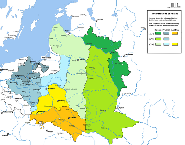
English: Partitions of the Polish-Lithuanian Commonwealth in 1772, 1793 and 1795.
Deutsch: Die Teilungen Polen-Litauens 1772, 1793 und 1795. |
| تریخ | (UTC) |
| سروت | |
| لکھاری |
|
| دوجے ورژن | العربيَّة |
| This is a retouched picture, which means that it has been digitally altered from its original version. Modifications: new colours. The original can be viewed here: Rzeczpospolita Rozbiory 3.png:
|

|
This historical map image could be re-created using vector graphics as an SVG file. This has several advantages; see Commons:Media for cleanup for more information. If an SVG form of this image is available, please upload it and afterwards replace this template with
{{vector version available|new image name}}.
It is recommended to name the SVG file “Partitions of Poland.svg”—then the template Vector version available (or Vva) does not need the new image name parameter. |
میں، اس کم دے کاپیرائٹ دا مالک، اس کم نوں اس لائسنس دے مطابق چھاپدا واں:

|
کاپی کرن، ونڈن تے بدلن دی ایس ڈوکومنٹ لئی اجازت دتی جاندی اے ایہناں GNU Free Documentation License, Version 1.2 شرطاں نال یا مگروں کسے وی چھپے ورین Free Software Foundation توں بنا کسے انویرینٹ سیکشن دے، ناں فرنٹ کور لکھت تے ناں بیک کور لکھت دے۔ لسنس دی اک کاپی سیکشن وچ ہیگی اے جہدا ناں اے GNU Free Documentation License۔ |
| ایس فائل نوں کریٹو کامنز Attribution 2.5 پولینڈ لائسنس دتا گیا. | ||
| ||
| اس لائسنس دا ٹیگ GFDL دے مطابق اس فائل چ پایا گیا اے licensing update۔ |
پہلا اپلوڈ دا ریکارڈ
This image is a derivative work of the following images:
- File:Rzeczpospolita_Rozbiory_3.png licensed with GFDL
- 2006-02-16T21:06:11Z Tomekpe 2000x1568 (246810 Bytes) Corrected mistakes: * Silesia at the time belonged to Prussia, whereas the map shows it belonging to Austria.
- 2005-12-25T21:52:24Z Tomekpe 2000x1568 (247161 Bytes) Halibutt's graphic with changing polish-russian border (Krasny Horodok area).
- 2005-01-10T13:41:59Z Halibutt 2000x1568 (343225 Bytes) Partitions of the [[Polish-Lithuanian Commonwealth]]{{User:Halibutt/maps}}{{User:Halibutt/GFDL}}[[Category:Maps of Poland]][[Category:Historical maps]]
Uploaded with derivativeFX
فائل دی تریخ
فائل نو اس ویلے دی حالت وچ ویکھن واسطے تاریخ/ویلے تے کلک کرو۔
| تریخ تے ویلہ | نکی مورت | پاسے | ورتن والا | تیپّݨی کرو | |
|---|---|---|---|---|---|
| موجودہ | ۱۲:۵۷, ۱۳ مارچ ۲۰۰۹ | | ۲,۰۰۰ × ۱,۵۶۸ (۲۶۱ کلوبائٹ) | Sneecs | Legendenfarben waren vertauscht |
| ۰۱:۰۳, ۶ مارچ ۲۰۰۹ |  | ۲,۰۰۰ × ۱,۵۶۸ (۲۶۱ کلوبائٹ) | Sneecs | {{Information |Description= |Source=*File:Rzeczpospolita_Rozbiory_3.png |Date=2009-03-05 19:59 (UTC) |Author=*File:Rzeczpospolita_Rozbiory_3.png: Halibutt *derivative work: ~~~ |Permission=see below |other_versions= }} {{RetouchedPicture|new |
فائل دی ورتوں
تھلے دتے گئے 1 صفحے اس فائل نال جُڑدے نیں
فائل ویاپک ورتوں
ایہہ دوجے وکیاں ایس فائل نوں ورتدے نیں –
- als.wikipedia.org تے ورتوں
- ar.wikipedia.org تے ورتوں
- azb.wikipedia.org تے ورتوں
- az.wikipedia.org تے ورتوں
- be-tarask.wikipedia.org تے ورتوں
- be.wikipedia.org تے ورتوں
- bg.wikipedia.org تے ورتوں
- br.wikipedia.org تے ورتوں
- ca.wikipedia.org تے ورتوں
- cdo.wikipedia.org تے ورتوں
- cs.wikipedia.org تے ورتوں
- da.wikipedia.org تے ورتوں
- de.wikipedia.org تے ورتوں
- el.wikipedia.org تے ورتوں
- en.wikipedia.org تے ورتوں
- eo.wikipedia.org تے ورتوں
ایس فائل دا ویکھو ہور جگت ورتن .