فائل:Palestinian authority map text.gif

ایس وکھالے دا ناپ: ۱۸۳ × ۵۹۷ پکسلز۔ دوجے ریزولوشنز: ۷۳ × ۲۴۰ پکسلز | ۳۲۶ × ۱,۰۶۴ پکسلز ۔
اصل فائل (۳۲۶ × ۱,۰۶۴ پکسلز, فائل حجم: ۲۵ کلوبائٹ, MIME type: image/gif)

|
This locator map image could be re-created using vector graphics as an SVG file. This has several advantages; see Commons:Media for cleanup for more information. If an SVG form of this image is available, please upload it and afterwards replace this template with
{{vector version available|new image name}}.
It is recommended to name the SVG file “Palestinian authority map text.svg”—then the template Vector version available (or Vva) does not need the new image name parameter. |
خلاصہ
| تفصیل |
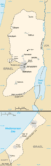
English: Map of West Bank and Gaza Strip |
| تریخ | |
| سروت | CIA World Factbook 2006 (from the West Bank and Gaza Strip entries) |
| لکھاری | CIA |
| اجازت (فائل نوں دوبارہ ورتنا) |
Public Domain as described in https://www.cia.gov/cia/publications/factbook/docs/contributor_copyright.html |
| دوجے ورژن | Palestinian_authority_map.gif |
لائسنس –
This image is in the public domain because it contains materials that originally came from the United States Central Intelligence Agency's World Factbook.
|
 |
لائسنس –
This image is in the public domain because it contains materials that originally came from the United States Central Intelligence Agency's World Factbook.
|
|
| Annotations | This image is annotated: View the annotations at Commons |
فائل دی تریخ
فائل نو اس ویلے دی حالت وچ ویکھن واسطے تاریخ/ویلے تے کلک کرو۔
| تریخ تے ویلہ | نکی مورت | پاسے | ورتن والا | تیپّݨی کرو | |
|---|---|---|---|---|---|
| موجودہ | ۰۰:۱۵, ۲ مئی ۲۰۱۱ | ۳۲۶ × ۱,۰۶۴ (۲۵ کلوبائٹ) | Ras67 | cropped | |
| ۰۵:۱۹, ۲۴ اگست ۲۰۰۸ | ۳۳۰ × ۱,۰۶۹ (۲۷ کلوبائٹ) | Koavf | {{Information |Description={{en|1=Map of West Bank and Gaza Strip}} |Source=CIA World Factbook 2006 (from the West Bank and Gaza Strip entries) |Author=CIA |Date=2006 |Permission=Public Domain as described in https://www.cia.gov/cia/publications/factbook/ |
فائل دی ورتوں
تھلے دتے گئے 18 صفحے اس فائل نال جُڑدے نیں
فائل ویاپک ورتوں
ایہہ دوجے وکیاں ایس فائل نوں ورتدے نیں –
- an.wikipedia.org تے ورتوں
- ast.wikipedia.org تے ورتوں
- es.wikipedia.org تے ورتوں
- gl.wikipedia.org تے ورتوں
- incubator.wikimedia.org تے ورتوں
- ro.wikipedia.org تے ورتوں
- sv.wikipedia.org تے ورتوں
- vi.wikipedia.org تے ورتوں