فائل:Pakistan population density.png
ایس وکھالے دا ناپ: ۶۴۰ × ۵۹۹ پکسلز۔ دوجے ریزولوشنز: ۲۵۶ × ۲۴۰ پکسلز | ۸۲۰ × ۷۶۸ پکسلز | ۱,۰۹۴ × ۱,۰۲۴ پکسلز | ۲,۱۸۷ × ۲,۰۴۸ پکسلز | ۵,۴۰۰ × ۵,۰۵۶ پکسلز ۔
اصل فائل (۵,۴۰۰ × ۵,۰۵۶ پکسلز, فائل حجم: ۱.۸۸ میگابائٹ, MIME type: image/png)

|
This file has been superseded by Population Density by Pakistani District - 2017 Census.SVG. It is recommended to use the other file. Please note that deleting superseded images requires consent. Reason to use the other file: "SVG File that uses a better template, is more detailed, and fixes many errors"
|
new file |
خلاصہ
| تفصیل |
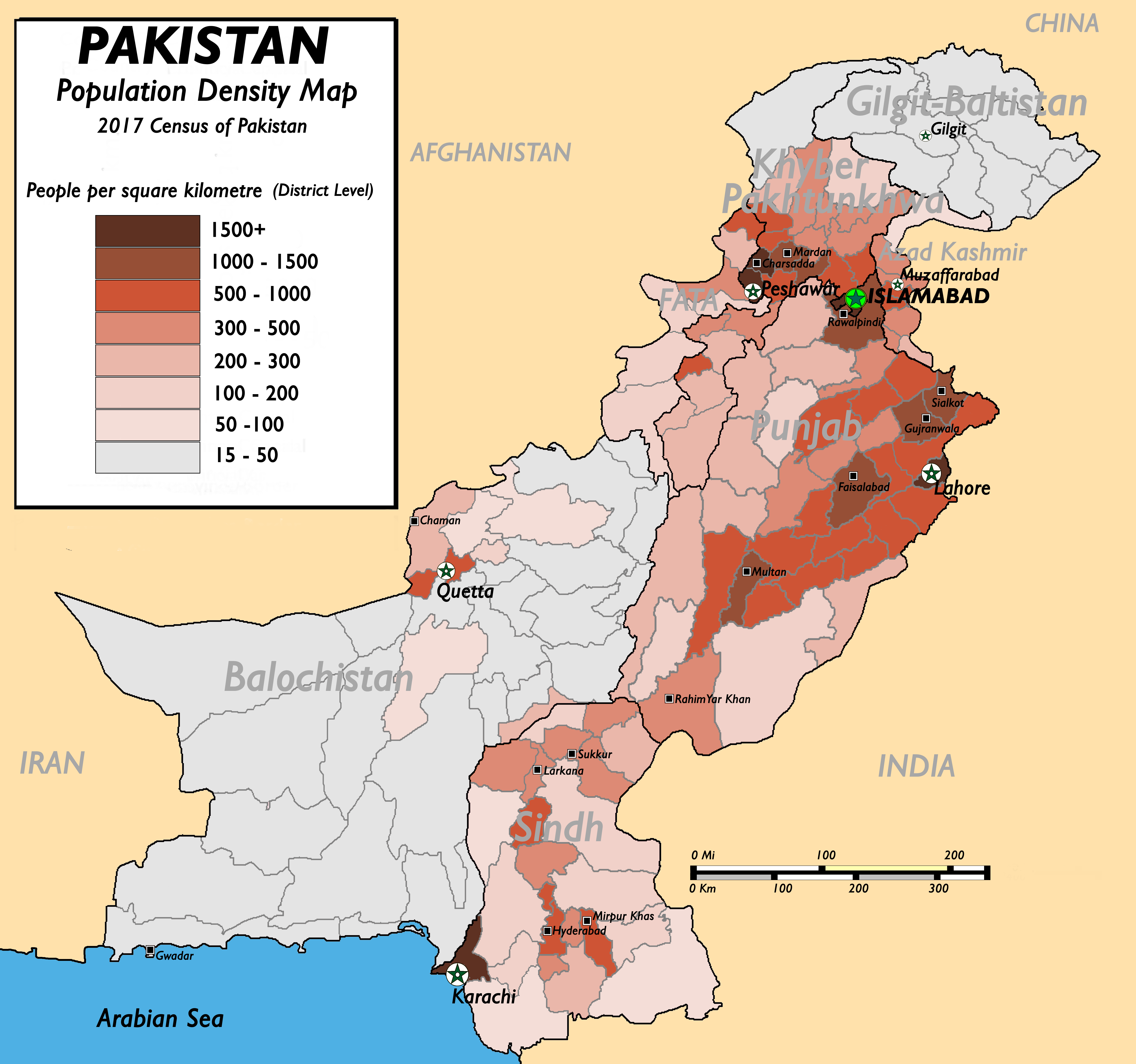
English: Pakistan Population Density Map (English). (Abbreviations used: 1. NWFP = North West Frontier Province, 2. FATA = Federally Administered Tribal Areas.) |
| تریخ | ۱۳ اگست ۲۰۰۹ (original upload date) |
| سروت |
(New version uploaded by using data from 2017 Pakistan Population Census, Official Website (Original text: I created this work by myself with the sources of World Trade Press and Population census organisation, Government of Pakistan.) |
| لکھاری | nomi887 (talk) |
لائسنس –
Nomi887 at English وکیپیڈیا، اس کم دے کاپیرائٹ دا مالک، اس کم نوں اس لائسنس دے مطابق چھاپدا واں:
ایس فائل نوں کریٹو کامنز Attribution 2.5 پولینڈ لائسنس دتا گیا.
کس دے ناں: Nomi887 at English وکیپیڈیا
- تہانوں کھلھ اے:
- حصہ کرنا – کاپی، ونڈنا تے کم بھیجنا
- فیر رلانا – کم نوں فٹ کرنا
- تھلے دتیاں شرطاں نال:
- کس دے ناں – تسیں لازمی ایس کم دے بناں والے بارے دسو جنج اونے آکھیا اے یا جنج لسنس چ آکھیا گیا ہے۔
- اکو جہا شئیر کرو۔ – اگر تسیں بدلدے یا ایس کم تے بناندے تے بنن والے کم نوں اینج دے لسنس نال ای ونڈو گے۔

|
کاپی کرن، ونڈن تے بدلن دی ایس ڈوکومنٹ لئی اجازت دتی جاندی اے ایہناں GNU Free Documentation License, Version 1.2 شرطاں نال یا مگروں کسے وی چھپے ورین Free Software Foundation توں بنا کسے انویرینٹ سیکشن دے، ناں فرنٹ کور لکھت تے ناں بیک کور لکھت دے۔ لسنس دی اک کاپی سیکشن وچ ہیگی اے جہدا ناں اے GNU Free Documentation License۔ |
تسیں اپنی مرضی دا لائسنس چݨ سکدے اوہ۔
پہلا اپلوڈ دا ریکارڈ
The original description page was here. All following user names refer to en.wikipedia.
- 2009-08-13 11:22 Brainlara73 1357×1348× (210478 bytes) Reverted to version as of 11:06, 13 August 2009
- 2009-08-13 11:07 Brainlara73 1357×1348× (210478 bytes) location corrected
- 2009-08-13 11:06 Brainlara73 1357×1348× (210478 bytes) location corrected
- 2009-08-13 09:57 Nomi887 1357×1348× (235717 bytes) More scrutinized version.
- 2009-07-07 11:18 Brainlara73 1361×1390× (195660 bytes) Added Jhelum in Punjab
- 2009-06-11 09:46 Nomi887 1361×1390× (212195 bytes) {{Information |Description = Pakistan Population Density Map (English). |Source = I created this work by myself with the sources of [http://www.bestcountryreports.com/Population_Map_Pakistan.html World Trade Press] and [http://www.statpak.gov
فائل دی تریخ
فائل نو اس ویلے دی حالت وچ ویکھن واسطے تاریخ/ویلے تے کلک کرو۔
| تریخ تے ویلہ | نکی مورت | پاسے | ورتن والا | تیپّݨی کرو | |
|---|---|---|---|---|---|
| موجودہ | ۱۷:۴۳, ۱۷ دسمبر ۲۰۱۸ | | ۵,۴۰۰ × ۵,۰۵۶ (۱.۸۸ میگابائٹ) | Nomi887 | New version as per Pakistan Population Census of 2017 by using data from #REDIRECTCensus Data, Pakistan Bureau of Statistics |
| ۱۲:۵۷, ۱۱ اپریل ۲۰۱۱ |  | ۱,۳۸۹ × ۱,۳۸۳ (۲۲۰ کلوبائٹ) | Nomi887 | minor corrections in locations and density | |
| ۲۲:۳۵, ۱۸ مارچ ۲۰۱۰ |  | ۱,۳۵۷ × ۱,۳۴۸ (۲۰۶ کلوبائٹ) | Ranveig | {{Information |Description={{en|Pakistan Population Density Map (English). ''(Abbreviations used: 1. NWFP = North West Frontier Province, 2. FATA = Federally Administered Tribal Areas.)''}} |Source=Transferred from [http://en.wikipedia.org en.wikipedia]<b |
فائل دی ورتوں
تھلے دتے گئے 2 صفحے اس فائل نال جُڑدے نیں
فائل ویاپک ورتوں
ایہہ دوجے وکیاں ایس فائل نوں ورتدے نیں –
- ba.wikipedia.org تے ورتوں
- bn.wikipedia.org تے ورتوں
- bs.wikipedia.org تے ورتوں
- de.wikipedia.org تے ورتوں
- diq.wikipedia.org تے ورتوں
- en.wikipedia.org تے ورتوں
- fr.wikipedia.org تے ورتوں
- fr.wikinews.org تے ورتوں
- hu.wikipedia.org تے ورتوں
- inh.wikipedia.org تے ورتوں
- io.wikipedia.org تے ورتوں
- ja.wikipedia.org تے ورتوں
- mr.wikipedia.org تے ورتوں
- nl.wikipedia.org تے ورتوں
- nl.wikinews.org تے ورتوں
- nn.wikipedia.org تے ورتوں
- no.wikipedia.org تے ورتوں
- pt.wikipedia.org تے ورتوں
- ru.wikipedia.org تے ورتوں
- th.wikipedia.org تے ورتوں
- uk.wikipedia.org تے ورتوں
- ur.wikipedia.org تے ورتوں
- vi.wikipedia.org تے ورتوں
- zh.wikipedia.org تے ورتوں