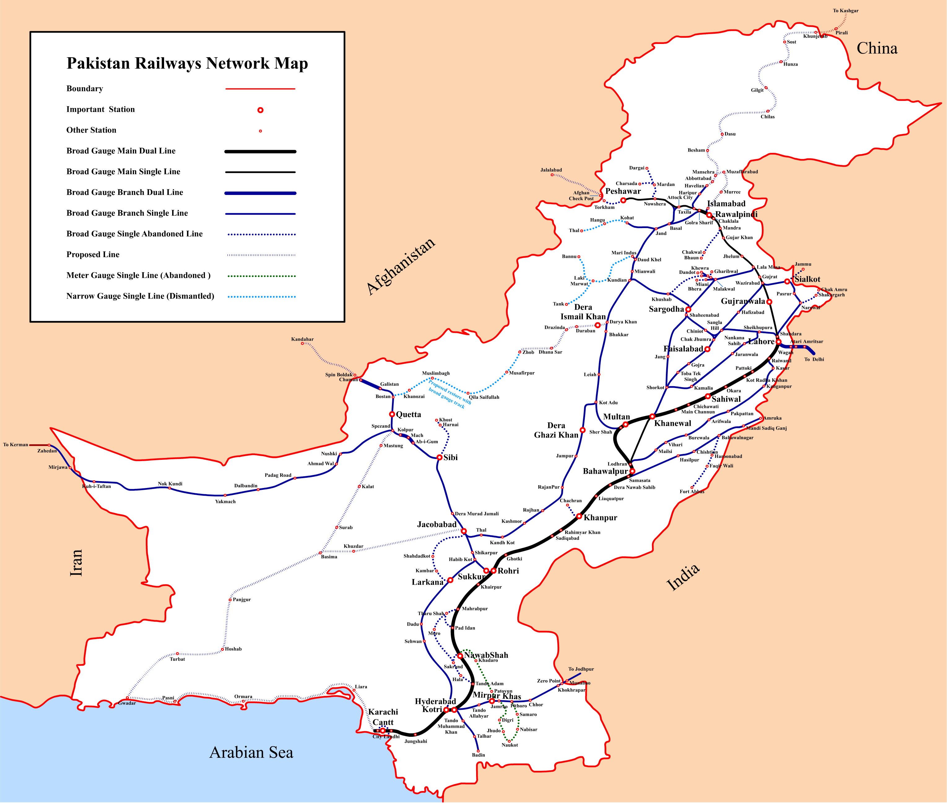
فائل:Pakistan Railways Network Map.png
ایس وکھالے دا ناپ: ۷۰۷ × ۶۰۰ پکسلز۔ دوجے ریزولوشنز: ۲۸۳ × ۲۴۰ پکسلز | ۵۶۶ × ۴۸۰ پکسلز | ۹۰۵ × ۷۶۸ پکسلز | ۱,۲۰۷ × ۱,۰۲۴ پکسلز | ۲,۴۱۴ × ۲,۰۴۸ پکسلز | ۳,۰۵۹ × ۲,۵۹۵ پکسلز ۔
اصل فائل (۳,۰۵۹ × ۲,۵۹۵ پکسلز, فائل حجم: ۶۴۸ کلوبائٹ, MIME type: image/png)
خلاصہ
| Description |
English: Pakistan Railways Network Map |
|||||||||
| تریخ | ||||||||||
| سروت | آپݨا کم | |||||||||
| Creator | ||||||||||
| Geotemporal data | ||||||||||
| Bounding box |
|
|||||||||
| Georeferencing | ||||||||||
لائسنس –
میں، اس کم دے کاپیرائٹ دا مالک، اس کم نوں اس لائسنس دے مطابق چھاپدا واں:
ایس فائل نوں کریٹو کامنز Attribution 2.5 پولینڈ لائسنس دتا گیا.
- تہانوں کھلھ اے:
- حصہ کرنا – کاپی، ونڈنا تے کم بھیجنا
- فیر رلانا – کم نوں فٹ کرنا
- تھلے دتیاں شرطاں نال:
- کس دے ناں – تسیں لازمی ایس کم دے بناں والے بارے دسو جنج اونے آکھیا اے یا جنج لسنس چ آکھیا گیا ہے۔
- اکو جہا شئیر کرو۔ – اگر تسیں بدلدے یا ایس کم تے بناندے تے بنن والے کم نوں اینج دے لسنس نال ای ونڈو گے۔
فائل دی تریخ
فائل نو اس ویلے دی حالت وچ ویکھن واسطے تاریخ/ویلے تے کلک کرو۔
| تریخ تے ویلہ | نکی مورت | پاسے | ورتن والا | تیپّݨی کرو | |
|---|---|---|---|---|---|
| موجودہ | ۲۲:۴۹, ۳ ستمبر ۲۰۱۶ | | ۳,۰۵۹ × ۲,۵۹۵ (۶۴۸ کلوبائٹ) | Adnanleon | Updated Karachi-Lahore dual railway track, Added Karachi-Gwadar, Islamabad-Muzaffarabad and Basima-Jacobabad proposed railway lines. |
| ۱۶:۴۴, ۲۷ جنوری ۲۰۱۴ |  | ۳,۰۳۲ × ۲,۵۷۲ (۵۹۱ کلوبائٹ) | RaviC | + Jammu link | |
| ۰۱:۵۴, ۱ اگست ۲۰۱۳ |  | ۳,۰۳۲ × ۲,۵۷۲ (۶۲۸ کلوبائٹ) | Adnanleon | Fill white color in center | |
| ۰۱:۲۷, ۱ اگست ۲۰۱۳ |  | ۳,۰۳۲ × ۲,۵۷۲ (۵۶۰ کلوبائٹ) | Adnanleon | Correction in Sahiwal-Raiwind section and Pak-China proposed railway line | |
| ۱۳:۲۷, ۱ مارچ ۲۰۱۲ |  | ۳,۰۴۲ × ۲,۵۵۷ (۵۱۷ کلوبائٹ) | Nomi887 | Added colour (reason: to make map prominent) | |
| ۰۳:۲۱, ۲۹ فروری ۲۰۱۲ |  | ۳,۰۴۲ × ۲,۵۵۷ (۵۸۵ کلوبائٹ) | Sven Manguard | Removing time and author from image. This is *NOT* the version sent by OTRS, that one is immediately below. | |
| ۰۳:۱۲, ۲۹ فروری ۲۰۱۲ |  | ۳,۰۴۲ × ۲,۵۵۷ (۵۹۵ کلوبائٹ) | Sven Manguard | Update sent via OTRS photosubmissions | |
| ۲۳:۵۵, ۲۲ نومبر ۲۰۱۱ |  | ۳,۰۱۰ × ۲,۵۴۰ (۴۶۶ کلوبائٹ) | Adnanleon |
فائل دی ورتوں
تھلے دتے گئے 12 صفحے اس فائل نال جُڑدے نیں
فائل ویاپک ورتوں
ایہہ دوجے وکیاں ایس فائل نوں ورتدے نیں –
- bn.wikipedia.org تے ورتوں
- de.wikipedia.org تے ورتوں
- de.wikivoyage.org تے ورتوں
- en.wikipedia.org تے ورتوں
- en.wikivoyage.org تے ورتوں
- eo.wikipedia.org تے ورتوں
- fr.wikipedia.org تے ورتوں
- hi.wikipedia.org تے ورتوں
- hu.wikipedia.org تے ورتوں
- it.wikivoyage.org تے ورتوں
- ja.wikipedia.org تے ورتوں
- mr.wikipedia.org تے ورتوں
- pl.wikipedia.org تے ورتوں
- ru.wikipedia.org تے ورتوں
- sd.wikipedia.org تے ورتوں
- skr.wikipedia.org تے ورتوں
- uk.wikipedia.org تے ورتوں
ایس فائل دا ویکھو ہور جگت ورتن .