فائل:Netzarim junction map.png
ایس وکھالے دا ناپ: ۵۵۷ × ۵۹۹ پکسلز۔ دوجے ریزولوشنز: ۲۲۳ × ۲۴۰ پکسلز | ۴۴۶ × ۴۸۰ پکسلز | ۶۷۴ × ۷۲۵ پکسلز ۔
اصل فائل (۶۷۴ × ۷۲۵ پکسلز, فائل حجم: ۸۲ کلوبائٹ, MIME type: image/png)
خلاصہ

|
This locator map image could be re-created using vector graphics as an SVG file. This has several advantages; see Commons:Media for cleanup for more information. If an SVG form of this image is available, please upload it and afterwards replace this template with
{{vector version available|new image name}}.
It is recommended to name the SVG file “Netzarim junction map.svg”—then the template Vector version available (or Vva) does not need the new image name parameter. |
| تفصیل |
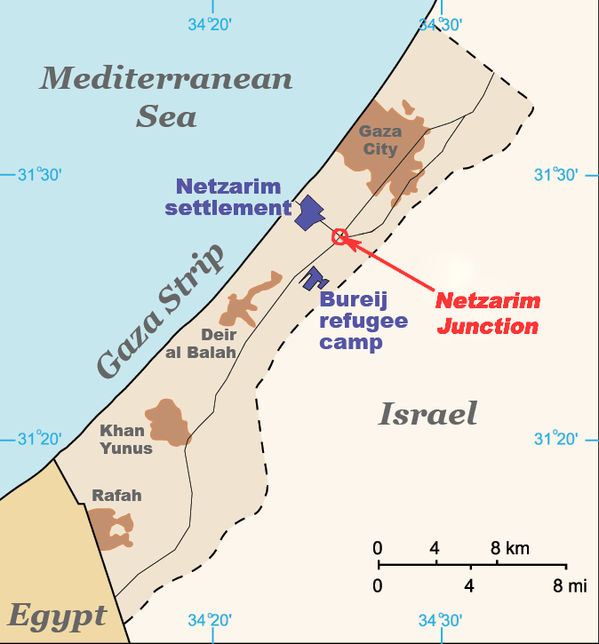
English: Map of the Gaza Strip indicating the locations of Bureij refugee camp, the former Netzarim settlement and the Netzarim Junction. Based on :Image:Gaza Strip map blank.svg. |
| تریخ | |
| سروت | آپݨا کم (Original text: I created this work entirely by myself.) |
| لکھاری | ChrisO (talk) |
لائسنس –
Vanished user 03 at English وکیپیڈیا، اس کم دے کاپیرائٹ دا مالک، اس کم نوں اس لائسنس دے مطابق چھاپدا واں:
ایس فائل نوں کریٹو کامنز Attribution 2.5 پولینڈ لائسنس دتا گیا.
کس دے ناں: Vanished user 03 at English وکیپیڈیا
- تہانوں کھلھ اے:
- حصہ کرنا – کاپی، ونڈنا تے کم بھیجنا
- فیر رلانا – کم نوں فٹ کرنا
- تھلے دتیاں شرطاں نال:
- کس دے ناں – تسیں لازمی ایس کم دے بناں والے بارے دسو جنج اونے آکھیا اے یا جنج لسنس چ آکھیا گیا ہے۔
- اکو جہا شئیر کرو۔ – اگر تسیں بدلدے یا ایس کم تے بناندے تے بنن والے کم نوں اینج دے لسنس نال ای ونڈو گے۔
پہلا اپلوڈ دا ریکارڈ
Transferred from en.wikipedia to Commons by Magnus Manske using CommonsHelper.
The original description page was here. All following user names refer to en.wikipedia.
- 2009-04-06 19:56 Jaakobou 674×725× (84061 bytes) Update by adding a marking and fixing colors to emphasize the junction where the al-Durrah event occurred.
- 2008-07-18 18:52 Vanished user 03 674×725× (28831 bytes) {{Information |Description=Map of the Gaza Strip indicating the locations of Bureij refugee camp, the former Netzarim settlement and the Netzarim Junction. Based on [[:Image:Gaza Strip map blank.svg]]. |Source=I created this work entirely by myself. |Date
فائل دی تریخ
فائل نو اس ویلے دی حالت وچ ویکھن واسطے تاریخ/ویلے تے کلک کرو۔
| تریخ تے ویلہ | نکی مورت | پاسے | ورتن والا | تیپّݨی کرو | |
|---|---|---|---|---|---|
| موجودہ | ۲۱:۰۸, ۱۹ فروری ۲۰۱۱ | | ۶۷۴ × ۷۲۵ (۸۲ کلوبائٹ) | File Upload Bot (Magnus Manske) | {{BotMoveToCommons|en.wikipedia|year={{subst:CURRENTYEAR}}|month={{subst:CURRENTMONTHNAME}}|day={{subst:CURRENTDAY}}}} {{Information |Description={{en|Map of the Gaza Strip indicating the locations of Bureij refugee camp, the former Netzarim settlement a |
فائل دی ورتوں
تھلے دتے گئے 1 صفحے اس فائل نال جُڑدے نیں
فائل ویاپک ورتوں
ایہہ دوجے وکیاں ایس فائل نوں ورتدے نیں –
- cy.wikipedia.org تے ورتوں
- en.wikipedia.org تے ورتوں
- es.wikipedia.org تے ورتوں
- he.wikipedia.org تے ورتوں
- id.wikipedia.org تے ورتوں
- ru.wikipedia.org تے ورتوں
- uk.wikipedia.org تے ورتوں
- ur.wikipedia.org تے ورتوں
- uz.wikipedia.org تے ورتوں
- vi.wikipedia.org تے ورتوں
- zh.wikipedia.org تے ورتوں