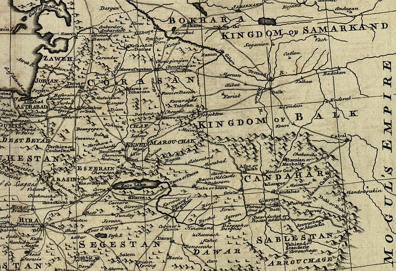
فائل:Map of Afghanistan during the Safavid and Moghul Empire.jpg

ایس وکھالے دا ناپ: ۸۰۰ × ۵۴۸ پکسلز۔ دوجے ریزولوشنز: ۳۲۰ × ۲۱۹ پکسلز | ۶۴۰ × ۴۳۹ پکسلز | ۱,۰۲۴ × ۷۰۲ پکسلز | ۱,۲۸۰ × ۸۷۸ پکسلز | ۲,۵۳۲ × ۱,۷۳۶ پکسلز ۔
اصل فائل (۲,۵۳۲ × ۱,۷۳۶ پکسلز, فائل حجم: ۱.۱۶ میگابائٹ, MIME type: image/jpeg)
فائل دی تریخ
فائل نو اس ویلے دی حالت وچ ویکھن واسطے تاریخ/ویلے تے کلک کرو۔
| تریخ تے ویلہ | نکی مورت | پاسے | ورتن والا | تیپّݨی کرو | |
|---|---|---|---|---|---|
| موجودہ | ۰۷:۵۰, ۲ مارچ ۲۰۱۱ |  | ۲,۵۳۲ × ۱,۷۳۶ (۱.۱۶ میگابائٹ) | Officer | {{Information |Description= |Source= |Date= |Author= |Permission= |other_versions= }} |
| ۰۷:۴۲, ۲ مارچ ۲۰۱۱ |  | ۲,۳۴۲ × ۱,۶۸۲ (۱.۰۴ میگابائٹ) | Officer | {{Information |Description= |Source= |Date= |Author= |Permission= |other_versions= }} | |
| ۰۷:۳۲, ۲ مارچ ۲۰۱۱ |  | ۲,۴۰۲ × ۱,۵۹۹ (۱.۰۲ میگابائٹ) | Officer | {{Information |Description= |Source= |Date= |Author= |Permission= |other_versions= }} | |
| ۰۶:۳۷, ۲ مارچ ۲۰۱۱ |  | ۲,۰۶۴ × ۱,۶۰۷ (۸۵۶ کلوبائٹ) | Officer | {{Information |Description= |Source= |Date= |Author= |Permission= |other_versions= }} | |
| ۱۹:۳۹, ۱۲ مارچ ۲۰۱۰ |  | ۱,۸۱۰ × ۱,۸۱۰ (۹۱۵ کلوبائٹ) | Officer | {{Information |Description=Map of Afghanistan during the Safavid and Mughal Empire, from the 16th century to 1747 when the current nation-state was created. |Source=[http://memory.loc.gov/ The Library of Congress, American Memory] - [http://memory.loc.gov | |
| ۰۸:۴۸, ۲۱ جنوری ۲۰۱۰ |  | ۲,۰۵۶ × ۱,۵۷۴ (۹۸۳ کلوبائٹ) | Officer | {{Information |Description=Map of Afghanistan during the Safavid and Mughal Empire, from the 16th century to 1747 when the current nation-state was created. |Source=[http://memory.loc.gov/ The Library of Congress, American Memory] - [http://memory.loc.gov | |
| ۰۶:۲۹, ۱۹ نومبر ۲۰۰۹ |  | ۱,۶۷۹ × ۱,۶۷۸ (۷۹۰ کلوبائٹ) | Officer | {{Information |Description=Map of Afghanistan during the Safavid and Mughal Empire, from the 16th century to 1747 when the current nation-state was created. |Source=[http://memory.loc.gov/ The Library of Congress, American Memory] - [http://memory.loc.gov |
فائل دی ورتوں
تھلے دتے گئے 1 صفحے اس فائل نال جُڑدے نیں
فائل ویاپک ورتوں
ایہہ دوجے وکیاں ایس فائل نوں ورتدے نیں –
- ar.wikipedia.org تے ورتوں
- azb.wikipedia.org تے ورتوں
- az.wikipedia.org تے ورتوں
- bn.wikipedia.org تے ورتوں
- el.wikipedia.org تے ورتوں
- en.wikipedia.org تے ورتوں
- fa.wikipedia.org تے ورتوں
- hi.wikipedia.org تے ورتوں
- id.wikipedia.org تے ورتوں
- it.wikipedia.org تے ورتوں
- ja.wikipedia.org تے ورتوں
- nl.wikipedia.org تے ورتوں
- no.wikipedia.org تے ورتوں
- pt.wikipedia.org تے ورتوں
- ru.wikipedia.org تے ورتوں
- ta.wikipedia.org تے ورتوں
- te.wikipedia.org تے ورتوں
- tg.wikipedia.org تے ورتوں
- uk.wikipedia.org تے ورتوں
- ur.wikipedia.org تے ورتوں
- www.wikidata.org تے ورتوں
- zh.wikipedia.org تے ورتوں
ایس فائل دا ویکھو ہور جگت ورتن .

