فائل:Map Europe 1923-en.svg

Size of this PNG preview of this SVG file: ۸۰۰ × ۵۴۳ پکسلز. دوجے ریزولوشنز: ۳۲۰ × ۲۱۷ پکسلز | ۶۴۰ × ۴۳۴ پکسلز | ۱,۰۲۴ × ۶۹۵ پکسلز | ۱,۲۸۰ × ۸۶۹ پکسلز | ۲,۵۶۰ × ۱,۷۳۸ پکسلز | ۱,۰۳۷ × ۷۰۴ پکسلز ۔
اصل فائل (ایس وی جی فائل، پکسل:۱,۰۳۷ × ۷۰۴، فائل سائز: ۱۸۸ کلوبائٹ)
| تفصیل |
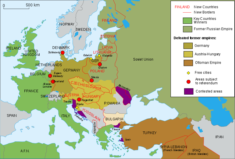
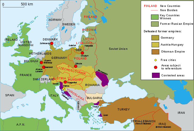
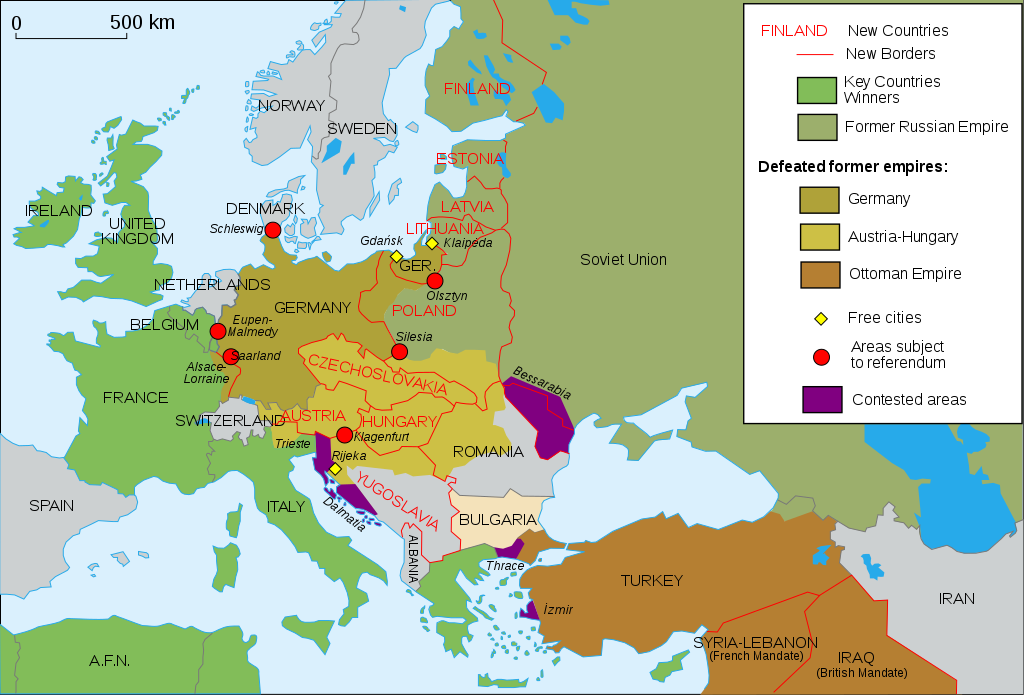
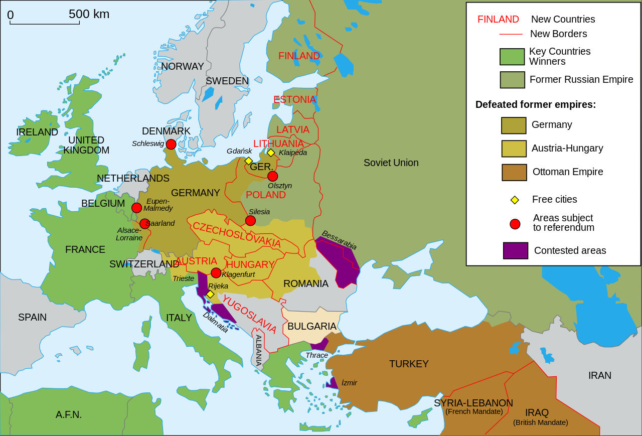
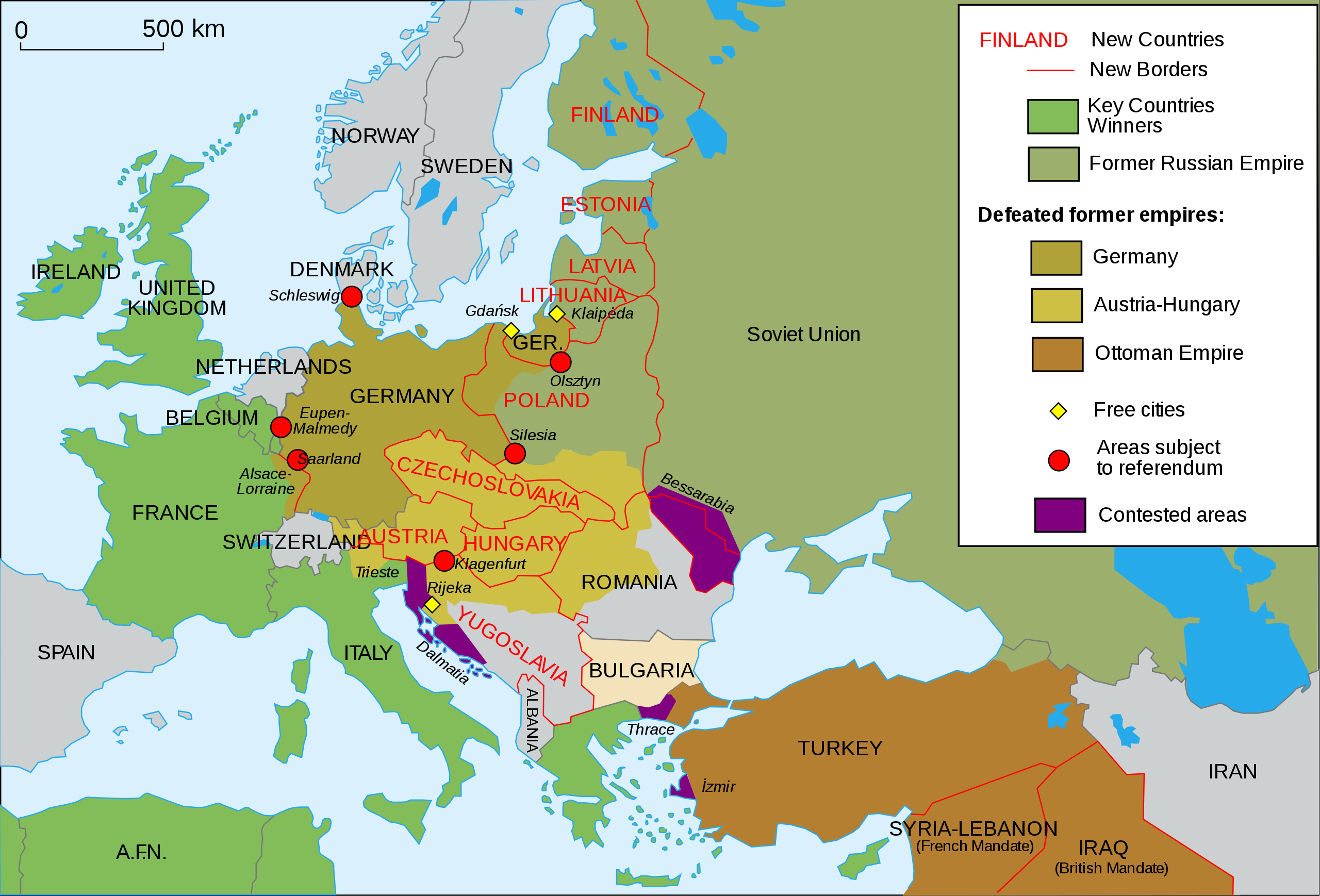
English: Map of Europe and Western Asia in 1923 after World War I Español: Mapa de Europa y Asia en 1923 Français : Carte de l'Europe en 1923. Português: Mapa da Europa e da Ásia em 1923 অসমীয়া: প্ৰথম বিশ্বযুদ্ধৰ পিছত ১৯২৩ চনত ইউৰোপ আৰু পশ্চিম এছিয়াৰ মানচিত্ৰ বাংলা : প্রথম বিশ্বযুদ্ধের পর ১৯২৩ সালে ইউরোপ ও পশ্চিম এশিয়ার মানচিত্র |
| تریخ | (UTC) |
| سروت | |
| لکھاری |
|
| دوجے ورژن |
Derivative works of this file: []
|
| SVG genesis | This vector image was created with Inkscape, or with something else. This file uses embedded text that can be easily translated using a text editor. |


میں، اس کم دے کاپیرائٹ دا مالک، اس کم نوں اس لائسنس دے مطابق چھاپدا واں:
ایس فائل نوں Creative Commons Attribution-Share Alike 2.5 Generic, 2.0 Generic and 1.0 Generic لسنس دتا گیا اے۔
- تہانوں کھلھ اے:
- حصہ کرنا – کاپی، ونڈنا تے کم بھیجنا
- فیر رلانا – کم نوں فٹ کرنا
- تھلے دتیاں شرطاں نال:
- کس دے ناں – تسیں لازمی ایس کم دے بناں والے بارے دسو جنج اونے آکھیا اے یا جنج لسنس چ آکھیا گیا ہے۔
- اکو جہا شئیر کرو۔ – اگر تسیں بدلدے یا ایس کم تے بناندے تے بنن والے کم نوں اینج دے لسنس نال ای ونڈو گے۔
پہلا اپلوڈ دا ریکارڈ
This image is a derivative work of the following images:
- File:Map_Europe_1923-fr.svg licensed with Cc-by-sa-2.5,2.0,1.0, Cc-by-sa-2.5,2.0,1.0/en
- 2007-04-19T18:31:16Z Bibi Saint-Pol 1037x704 (191242 Bytes) {{Information |Description= {{en|Map of Europe in 1923.}} {{fr|Carte de l'Europe en 1923.}} |Source=Own work |Date=2007-02-16 |Author=[[User:Historicair|Historicair]] |Permission={{self2|GFDL|cc-by-sa-2.5,2.0,1.0}} |other_ver
Uploaded with derivativeFX

|
This SVG file contains embedded text that can be translated into your language, using any capable SVG editor, text editor or the SVG Translate tool. For more information see: About translating SVG files. |
فائل دی تریخ
فائل نو اس ویلے دی حالت وچ ویکھن واسطے تاریخ/ویلے تے کلک کرو۔
| تریخ تے ویلہ | نکی مورت | پاسے | ورتن والا | تیپّݨی کرو | |
|---|---|---|---|---|---|
| موجودہ | ۱۸:۴۲, ۱۱ نومبر ۲۰۱۵ | | ۱,۰۳۷ × ۷۰۴ (۱۸۸ کلوبائٹ) | Oosterhagen | The Netherlands as neutral |
| ۱۹:۲۴, ۱۵ اگست ۲۰۱۵ |  | ۱,۰۳۷ × ۷۰۴ (۱۷۷ کلوبائٹ) | Fluteflute | Correct misspelling. Sweeden -> Sweden | |
| ۲۱:۲۱, ۱۳ جنوری ۲۰۰۹ |  | ۱,۰۳۷ × ۷۰۴ (۱۸۷ کلوبائٹ) | Fluteflute | small text changes | |
| ۲۱:۱۷, ۱۳ جنوری ۲۰۰۹ |  | ۱,۰۳۷ × ۷۰۴ (۱۸۷ کلوبائٹ) | Fluteflute | {{Information |Description={{en|Map of Europe in 1923.}} {{fr|Carte de l'Europe en 1923.}} |Source=*File:Map_Europe_1923-fr.svg |Date=2009-01-13 16:16 (UTC) |Author=*derivative work: ~~~ *File:Map_Europe_1923-fr.svg: [[User:Historicair|Histori |
فائل دی ورتوں
تھلے دتے گئے 2 صفحے اس فائل نال جُڑدے نیں
فائل ویاپک ورتوں
ایہہ دوجے وکیاں ایس فائل نوں ورتدے نیں –
- af.wikipedia.org تے ورتوں
- ar.wikipedia.org تے ورتوں
- azb.wikipedia.org تے ورتوں
- az.wikipedia.org تے ورتوں
- be-tarask.wikipedia.org تے ورتوں
- ca.wikipedia.org تے ورتوں
- ckb.wikipedia.org تے ورتوں
- cy.wikipedia.org تے ورتوں
- en.wikipedia.org تے ورتوں
- Molotov–Ribbentrop Pact
- Nation state
- Self-determination
- Treaty of Versailles
- Woodrow Wilson
- 20th century
- Flight and expulsion of Germans (1944–1950)
- Balkanization
- Aftermath of World War I
- Revanchism
- Causes of World War II
- Territorial evolution of Russia
- History of Western civilization
- List of irredentist claims or disputes
- World War I
- List of national border changes (1914–present)
- Presidency of Woodrow Wilson
- Presidency of Warren G. Harding
- January 1920
- Wikipedia:Graphics Lab/Map workshop/Archive/2016
- Portal:Modern history
- Wikipedia:WikiProject Military history/News/June 2019/Op-ed
- History of U.S. foreign policy, 1913–1933
- User:Sm8900/harding
- en.wikibooks.org تے ورتوں
- eo.wikipedia.org تے ورتوں
- eu.wikipedia.org تے ورتوں
- fa.wikipedia.org تے ورتوں
- fi.wikipedia.org تے ورتوں
- fi.wikibooks.org تے ورتوں
- ga.wikipedia.org تے ورتوں
- hy.wikipedia.org تے ورتوں
- hyw.wikipedia.org تے ورتوں
- id.wikipedia.org تے ورتوں
- it.wikipedia.org تے ورتوں
ایس فائل دا ویکھو ہور جگت ورتن .