فائل:Map-of-southeast-asia 900 CE.png
ایس وکھالے دا ناپ: ۴۲۶ × ۶۰۰ پکسلز۔ دوجے ریزولوشنز: ۱۷۰ × ۲۴۰ پکسلز | ۳۴۱ × ۴۸۰ پکسلز | ۷۹۱ × ۱,۱۱۴ پکسلز ۔
اصل فائل (۷۹۱ × ۱,۱۱۴ پکسلز, فائل حجم: ۱۸۲ کلوبائٹ, MIME type: image/png)
khmerempire3.jpg
خلاصہ
| تفصیل |
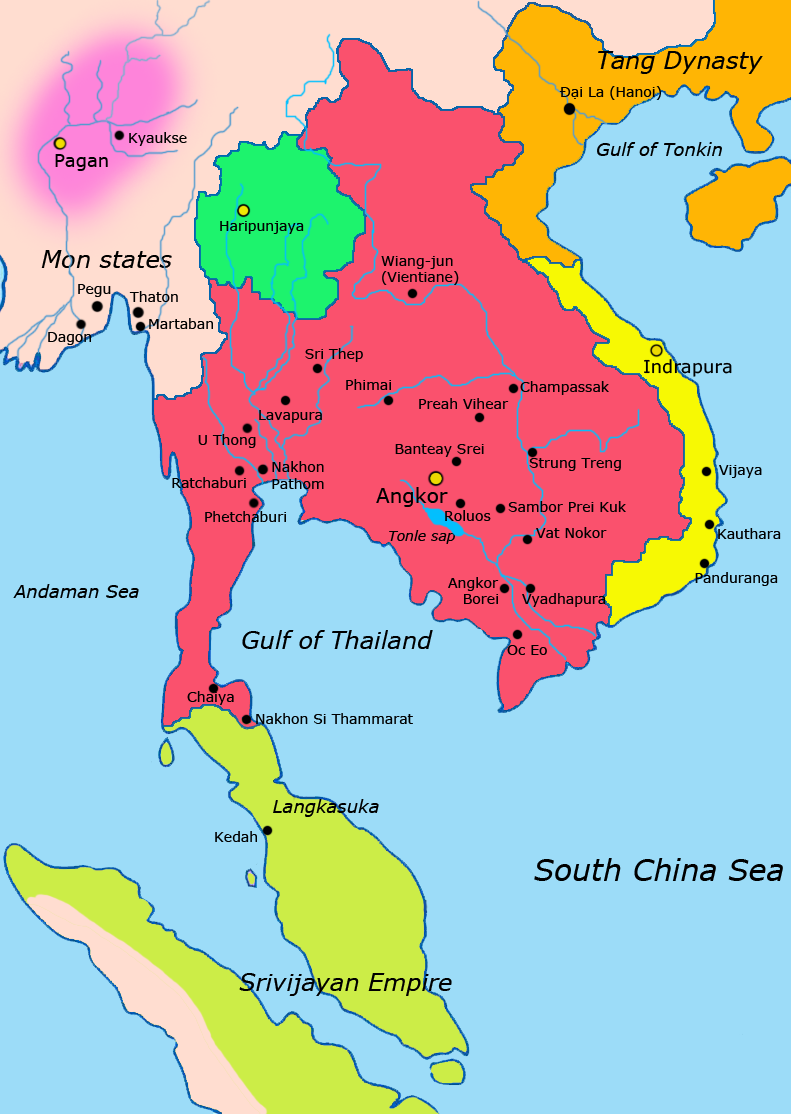
English: Map of Southeast Asia circa 900 CE, showing the Khmer Empire in red, Champa in yellow and Haripunjaya in light Green plus additional surrounding states.
sources i used for this work include http://ecaimaps.berkeley.edu/animations/2003_03_khmer_animation.swf http://www.britannica.com/EBchecked/media/3395/Khmer-empire-1200 Atlas of world history, Patrick Karl O'brien Societies, Networks, and Transitions: A Global History, Volume B. Craig A.Lockard http://upload.wikimedia.org/wikipedia/commons/thumb/4/45/Srivijaya_Empire.svg/2000px-Srivijaya_Empire.svg.png File:DvaravatiMapThailand.png http://upload.wikimedia.org/wikipedia/commons/e/eb/Thailand_2002_CIA_map.jpgBahasa Indonesia: Peta Asia Tenggara sekitar tahun 900 M, menampilkan Kerajaan Khmer dengan warna merah, Champa dengan warna kuning dan Haripunjaya dengan warna hijau beserta beberapa negara-negara lainnya. |
|||
| تریخ | ||||
| سروت | آپݨا کم | |||
| لکھاری | Javierfv1212 | |||
| دوجے ورژن |
|


لائسنس –
میں، اس کم دے کاپیرائٹ دا مالک، اس کم نوں اس لائسنس دے مطابق چھاپدا واں:
| ایس فائل نوں ایہ لسنس کریٹو کامنز CC0 1.0 یونیورسل پبلک ڈومین ڈیڈیکیشن دتا گیا اے۔ | |
| اوہ بندا جینے اے کم کیتا اے اونے اے کم public domain دے ناں لایا اے تے سارے حقاں نوں چھڈ دتا اے۔ تسیں اینو کاروبار کم لئی ورت سکدے اے یا بدل سکدے او بنا کسے اجازت دے۔
|
فائل دی تریخ
فائل نو اس ویلے دی حالت وچ ویکھن واسطے تاریخ/ویلے تے کلک کرو۔
| تریخ تے ویلہ | نکی مورت | پاسے | ورتن والا | تیپّݨی کرو | |
|---|---|---|---|---|---|
| موجودہ | ۱۹:۱۳, ۸ اپریل ۲۰۱۱ | | ۷۹۱ × ۱,۱۱۴ (۱۸۲ کلوبائٹ) | Ras67 | cropped |
| ۰۷:۱۳, ۲۸ مارچ ۲۰۱۱ |  | ۸۰۰ × ۱,۱۲۵ (۲۲۲ کلوبائٹ) | Javierfv1212 | {{Information |Description ={{en|1=Map of South-east asia circa 900 CE, showing the Khmer Empire in red, Champa in yellow and Haripunjaya in light Green plus additional surrounding states. sources i used for this work include http://ecaimaps.berkele |
فائل دی ورتوں
تھلے دتے گئے 1 صفحے اس فائل نال جُڑدے نیں
فائل ویاپک ورتوں
ایہہ دوجے وکیاں ایس فائل نوں ورتدے نیں –
- af.wikipedia.org تے ورتوں
- ar.wikipedia.org تے ورتوں
- azb.wikipedia.org تے ورتوں
- az.wikipedia.org تے ورتوں
- bg.wikipedia.org تے ورتوں
- ca.wikipedia.org تے ورتوں
- ceb.wikipedia.org تے ورتوں
- cs.wikipedia.org تے ورتوں
- el.wikipedia.org تے ورتوں
- en.wikipedia.org تے ورتوں
- eo.wikipedia.org تے ورتوں
- et.wikipedia.org تے ورتوں
- eu.wikipedia.org تے ورتوں
- fa.wikipedia.org تے ورتوں
- fi.wikipedia.org تے ورتوں
- fr.wikipedia.org تے ورتوں
- gu.wikipedia.org تے ورتوں
- he.wikipedia.org تے ورتوں
- id.wikipedia.org تے ورتوں
- it.wikipedia.org تے ورتوں
- ja.wikipedia.org تے ورتوں
- ka.wikipedia.org تے ورتوں
- km.wikipedia.org تے ورتوں
- lo.wikipedia.org تے ورتوں
- lt.wikipedia.org تے ورتوں
- mg.wikipedia.org تے ورتوں
- ml.wikipedia.org تے ورتوں
ایس فائل دا ویکھو ہور جگت ورتن .