فائل:Malay language Spoken Area Map v1.png
اس توں وڈی مورت موجود نہیں۔
Malay_language_Spoken_Area_Map_v1.png (۳۳۳ × ۱۵۴ پکسلز, فائل حجم: ۴ کلوبائٹ, MIME type: image/png)
خلاصہ

|
This linguistic map image could be re-created using vector graphics as an SVG file. This has several advantages; see Commons:Media for cleanup for more information. If an SVG form of this image is available, please upload it and afterwards replace this template with
{{vector version available|new image name}}.
It is recommended to name the SVG file “Malay language Spoken Area Map v1.svg”—then the template Vector version available (or Vva) does not need the new image name parameter. |
| تفصیل |
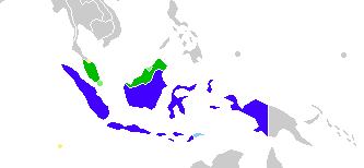
English: This is crop and edit of a .png export of the image at File:BlankMap-World6.svg. The original author released that image into the public domain for any use. This version is released under the CC-Zero license. |
| تریخ | ۱۳ فروری ۲۰۱۱ (original upload date) |
| سروت | Transferred from en.wikipedia to Commons by Zscout370 using CommonsHelper. |
| لکھاری | True at English وکیپیڈیا |
لائسنس –
True at English وکیپیڈیا، اس کم دے کاپیرائٹ دا مالک، اس کم نوں اس لائسنس دے مطابق چھاپدا واں:
| ایس فائل نوں ایہ لسنس کریٹو کامنز CC0 1.0 یونیورسل پبلک ڈومین ڈیڈیکیشن دتا گیا اے۔ | |
| اوہ بندا جینے اے کم کیتا اے اونے اے کم public domain دے ناں لایا اے تے سارے حقاں نوں چھڈ دتا اے۔ تسیں اینو کاروبار کم لئی ورت سکدے اے یا بدل سکدے او بنا کسے اجازت دے۔
|
پہلا اپلوڈ دا ریکارڈ
The original description page was here. All following user names refer to en.wikipedia.
- 2012-02-20 03:34 Kwamikagami 333×154× (4555 bytes) correct area in Thailand, add Cocos Isl.
- 2012-02-20 03:17 Kwamikagami 333×154× (4570 bytes) Reverted to version as of 23:23, 13 February 2011
- 2011-09-14 23:58 Niduzzi 736×386× (33038 bytes)
- 2011-02-13 23:23 True 333×154× (4570 bytes) This is crop and edit of a .png export of the image at http://en.wikipedia.org/wiki/File:BlankMap-World6.svg. The original author released that image into the public domain for any use. This version is released under the CC-Zero license.
فائل دی تریخ
فائل نو اس ویلے دی حالت وچ ویکھن واسطے تاریخ/ویلے تے کلک کرو۔
| تریخ تے ویلہ | نکی مورت | پاسے | ورتن والا | تیپّݨی کرو | |
|---|---|---|---|---|---|
| موجودہ | ۱۳:۲۳, ۲۵ فروری ۲۰۲۲ | | ۳۳۳ × ۱۵۴ (۴ کلوبائٹ) | Kwamikagami | no longer a map of where Malay is spoken |
| ۱۰:۵۲, ۲۶ اکتوبر ۲۰۱۸ |  | ۴,۳۸۷ × ۱,۹۲۲ (۳۳۶ کلوبائٹ) | Bennylin | Edit some colors | |
| ۱۰:۴۰, ۲۶ اکتوبر ۲۰۱۸ |  | ۴,۳۰۰ × ۱,۹۱۸ (۵۳۵ کلوبائٹ) | Bennylin | Change ugly map with PNG version of File:Maritime South East Asia.svg | |
| ۰۹:۵۱, ۲۱ جون ۲۰۱۲ |  | ۳۳۳ × ۱۵۴ (۴ کلوبائٹ) | File Upload Bot (Magnus Manske) | Transfered from en.wikipedia by User:zscout370 using CommonsHelper |
فائل دی ورتوں
اس فائل نال جڑیا کوئی صفحہ نئیں۔
فائل ویاپک ورتوں
ایہہ دوجے وکیاں ایس فائل نوں ورتدے نیں –
- ckb.wikipedia.org تے ورتوں
- el.wikipedia.org تے ورتوں
- en.wikipedia.org تے ورتوں
- es.wikipedia.org تے ورتوں
- fa.wikipedia.org تے ورتوں
- frr.wikipedia.org تے ورتوں
- id.wikipedia.org تے ورتوں
- incubator.wikimedia.org تے ورتوں
- mi.wikipedia.org تے ورتوں
- nl.wikipedia.org تے ورتوں
- zh.wikipedia.org تے ورتوں