فائل:Lion distribution.png
ایس وکھالے دا ناپ: ۶۸۷ × ۶۰۰ پکسلز۔ دوجے ریزولوشنز: ۲۷۵ × ۲۴۰ پکسلز | ۵۵۰ × ۴۸۰ پکسلز | ۸۸۰ × ۷۶۸ پکسلز ۔
اصل فائل (۸۸۰ × ۷۶۸ پکسلز, فائل حجم: ۵۱ کلوبائٹ, MIME type: image/png)

|
This map image could be re-created using vector graphics as an SVG file. This has several advantages; see Commons:Media for cleanup for more information. If an SVG form of this image is available, please upload it and afterwards replace this template with
{{vector version available|new image name}}.
It is recommended to name the SVG file “Lion distribution.svg”—then the template Vector version available (or Vva) does not need the new image name parameter. |
خلاصہ
| تفصیل |
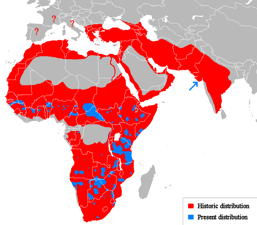
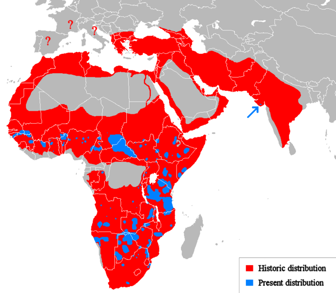
Euskara: Lehoien banaketa: Berdez gaur egun, gorriz historikoki.
Suomi: Leijonan levinneisyys vanhalla ajalla.
English: Geographical distribution of lions. Red (and blue) shows areas historically inhabited, blue shows areas currently inhabited.
Italiano: Areale storico (in rosso) ed attuale (in blu).
Русский: Ареал льва |
| تریخ | (UTC) |
| سروت |
Own work using:
|
| لکھاری | Tommyknocker (talk) |
| دوجے ورژن | Derivative works of this file: Lion distribution-ar.png |
لائسنس –
| اس کم نوں لوکاں لئی ایدے لکھاریTommyknocker at English وکیپیڈیا نے دے دتا اے، اے سارے جگ واسطے لاگو اے۔ کج ملکاں چ قانونی طور تے اے ممکن نئیں اے؛ اگر انج ای اے ے: Tommyknocker ہر کسے نوں اس کم نوں کسے وی مقصد واسطے ورتن دا بغیر کسے شرط دے حق دیندا واں، اگر اوہ قانون دے خلاف نا ہوۓ۔ |
پہلا اپلوڈ دا ریکارڈ
Transferred from en.wikipedia to Commons by Egmontaz using CommonsHelper.
The original description page was here. All following user names refer to en.wikipedia.
- 2009-08-26 11:21 Tommyknocker 882×770× (42518 bytes) '
- 2009-08-24 21:02 Tommyknocker 882×770× (42434 bytes) {{Information |Description = |Source = I (~~~) created this work entirely by myself. |Date = ~~~~~ |Author = ~~~ |other_versions = }}
فائل دی تریخ
فائل نو اس ویلے دی حالت وچ ویکھن واسطے تاریخ/ویلے تے کلک کرو۔
| تریخ تے ویلہ | نکی مورت | پاسے | ورتن والا | تیپّݨی کرو | |
|---|---|---|---|---|---|
| موجودہ | ۱۶:۵۱, ۲۲ مارچ ۲۰۱۸ | | ۸۸۰ × ۷۶۸ (۵۱ کلوبائٹ) | Maphobbyist | Check |
| ۱۶:۲۳, ۲۲ مارچ ۲۰۱۸ |  | ۸۸۰ × ۷۶۸ (۵۱ کلوبائٹ) | Maphobbyist | South Sudan border | |
| ۰۶:۰۷, ۱۵ مئی ۲۰۱۲ |  | ۸۸۰ × ۷۶۸ (۳۳ کلوبائٹ) | Ras67 | cropped, optimized | |
| ۱۹:۰۶, ۱۹ اپریل ۲۰۱۰ |  | ۸۸۲ × ۷۷۰ (۵۹ کلوبائٹ) | MPF | Change red/green to red/blue to avoid problems for viewers with red-green colourblindness | |
| ۰۱:۰۰, ۱۲ جنوری ۲۰۱۰ |  | ۸۸۲ × ۷۷۰ (۴۴ کلوبائٹ) | Tommyknocker | Distribution in Southern Europe during historical times controversial, therefore now represented with question marks. | |
| ۲۲:۰۱, ۲ نومبر ۲۰۰۹ |  | ۸۸۲ × ۷۷۰ (۴۲ کلوبائٹ) | File Upload Bot (Magnus Manske) | {{BotMoveToCommons|en.wikipedia|year={{subst:CURRENTYEAR}}|month={{subst:CURRENTMONTHNAME}}|day={{subst:CURRENTDAY}}}} {{Information |Description={{en|''no original description''}} |Source=Transferred from [http://en.wikipedia.org en.wikipedia]; transfer |
فائل دی ورتوں
تھلے دتے گئے 2 صفحے اس فائل نال جُڑدے نیں
فائل ویاپک ورتوں
ایہہ دوجے وکیاں ایس فائل نوں ورتدے نیں –
- ab.wikipedia.org تے ورتوں
- af.wikipedia.org تے ورتوں
- alt.wikipedia.org تے ورتوں
- am.wikipedia.org تے ورتوں
- ary.wikipedia.org تے ورتوں
- arz.wikipedia.org تے ورتوں
- ast.wikipedia.org تے ورتوں
- as.wikipedia.org تے ورتوں
- azb.wikipedia.org تے ورتوں
- ban.wikipedia.org تے ورتوں
- ba.wikipedia.org تے ورتوں
- bcl.wikipedia.org تے ورتوں
- be.wikipedia.org تے ورتوں
- bg.wikipedia.org تے ورتوں
- bh.wikipedia.org تے ورتوں
- bn.wikipedia.org تے ورتوں
- bs.wikipedia.org تے ورتوں
- ca.wikipedia.org تے ورتوں
- ca.wikiquote.org تے ورتوں
- ceb.wikipedia.org تے ورتوں
- ce.wikipedia.org تے ورتوں
- ckb.wikipedia.org تے ورتوں
- cs.wikipedia.org تے ورتوں
- de.wikipedia.org تے ورتوں
- de.wikibooks.org تے ورتوں
- diq.wikipedia.org تے ورتوں
- el.wikipedia.org تے ورتوں
- en.wikipedia.org تے ورتوں
- eo.wikipedia.org تے ورتوں
- eo.wiktionary.org تے ورتوں
- es.wikipedia.org تے ورتوں
- es.wikibooks.org تے ورتوں
- et.wikipedia.org تے ورتوں
- eu.wikipedia.org تے ورتوں
ایس فائل دا ویکھو ہور جگت ورتن .