فائل:Lincoln Sea map.png
ایس وکھالے دا ناپ: ۶۵۷ × ۶۰۰ پکسلز۔ دوجے ریزولوشنز: ۲۶۳ × ۲۴۰ پکسلز | ۵۲۶ × ۴۸۰ پکسلز | ۱,۰۰۰ × ۹۱۳ پکسلز ۔
اصل فائل (۱,۰۰۰ × ۹۱۳ پکسلز, فائل حجم: ۳۰۲ کلوبائٹ, MIME type: image/png)

|
This locator map image could be re-created using vector graphics as an SVG file. This has several advantages; see Commons:Media for cleanup for more information. If an SVG form of this image is available, please upload it and afterwards replace this template with
{{vector version available|new image name}}.
It is recommended to name the SVG file “Lincoln Sea map.svg”—then the template Vector version available (or Vva) does not need the new image name parameter. |
| Camera location | | View this and other nearby images on: OpenStreetMap |
|---|
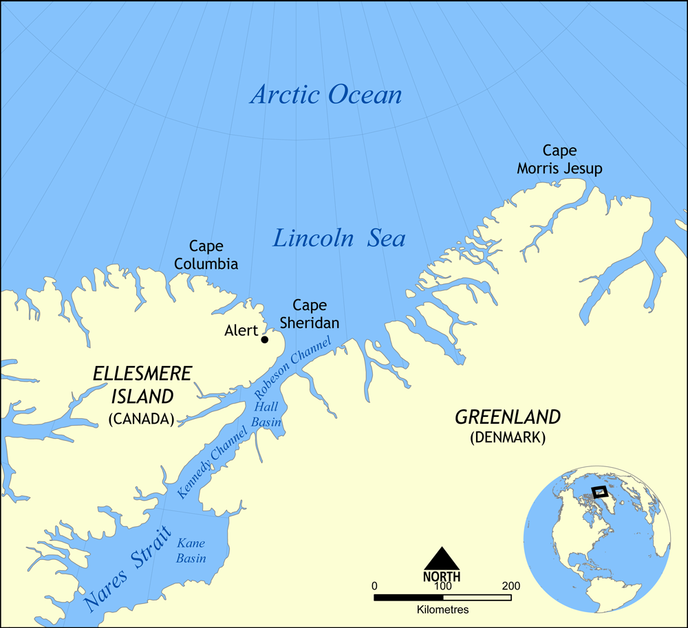
Map showing the location of the Lincoln Sea, part of the Arctic Ocean. Also shows Cape Columbia and Cape Morris Jesup.
Created by NormanEinstein, May 30, 2006.
میں، اس کم دے کاپیرائٹ دا مالک، اس کم نوں اس لائسنس دے مطابق چھاپدا واں:

|
کاپی کرن، ونڈن تے بدلن دی ایس ڈوکومنٹ لئی اجازت دتی جاندی اے ایہناں GNU Free Documentation License, Version 1.2 شرطاں نال یا مگروں کسے وی چھپے ورین Free Software Foundation توں بنا کسے انویرینٹ سیکشن دے، ناں فرنٹ کور لکھت تے ناں بیک کور لکھت دے۔ لسنس دی اک کاپی سیکشن وچ ہیگی اے جہدا ناں اے GNU Free Documentation License۔ |
| ایس فائل نوں کریٹو کامنز Attribution 2.5 پولینڈ لائسنس دتا گیا. | ||
| ||
| اس لائسنس دا ٹیگ GFDL دے مطابق اس فائل چ پایا گیا اے licensing update۔ |
فائل دی تریخ
فائل نو اس ویلے دی حالت وچ ویکھن واسطے تاریخ/ویلے تے کلک کرو۔
| تریخ تے ویلہ | نکی مورت | پاسے | ورتن والا | تیپّݨی کرو | |
|---|---|---|---|---|---|
| موجودہ | ۲۱:۰۱, ۷ اگست ۲۰۰۷ | | ۱,۰۰۰ × ۹۱۳ (۳۰۲ کلوبائٹ) | NormanEinstein | Updated map. Slightly larger size. |
| ۰۲:۱۴, ۷ اگست ۲۰۰۷ |  | ۶۵۷ × ۶۰۰ (۱۸۵ کلوبائٹ) | Eivindgh | ||
| ۰۲:۱۳, ۷ اگست ۲۰۰۷ |  | ۶۵۷ × ۶۰۰ (۱۸۵ کلوبائٹ) | Eivindgh | ||
| ۱۹:۰۲, ۳۰ مئی ۲۰۰۶ |  | ۹۹۶ × ۹۰۹ (۱۰۴ کلوبائٹ) | NormanEinstein | {{Information Map showing the location of the Lincoln Sea, part of the Arctic Ocean. Also shows Cape Columbia and Cape Morris Jesup. Created by NormanEinstein, May 30, 2006. {{GFDL-self}} Category:Maps of seas |
فائل دی ورتوں
تھلے دتے گئے 1 صفحے اس فائل نال جُڑدے نیں
فائل ویاپک ورتوں
ایہہ دوجے وکیاں ایس فائل نوں ورتدے نیں –
- af.wikipedia.org تے ورتوں
- ar.wikipedia.org تے ورتوں
- ast.wikipedia.org تے ورتوں
- azb.wikipedia.org تے ورتوں
- az.wikipedia.org تے ورتوں
- bg.wikipedia.org تے ورتوں
- bn.wikipedia.org تے ورتوں
- bs.wikipedia.org تے ورتوں
- ca.wikipedia.org تے ورتوں
- ceb.wikipedia.org تے ورتوں
- cs.wikipedia.org تے ورتوں
- da.wikipedia.org تے ورتوں
- de.wikipedia.org تے ورتوں
- en.wikipedia.org تے ورتوں
- es.wikipedia.org تے ورتوں
- et.wikipedia.org تے ورتوں
- eu.wikipedia.org تے ورتوں
- fa.wikipedia.org تے ورتوں
- fi.wikipedia.org تے ورتوں
- fr.wikipedia.org تے ورتوں
- he.wikipedia.org تے ورتوں
ایس فائل دا ویکھو ہور جگت ورتن .