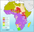
فائل:Languages of Africa map.svg

Size of this PNG preview of this SVG file: ۶۲۹ × ۵۹۹ پکسلز. دوجے ریزولوشنز: ۲۵۲ × ۲۴۰ پکسلز | ۵۰۴ × ۴۸۰ پکسلز | ۸۰۶ × ۷۶۸ پکسلز | ۱,۰۷۵ × ۱,۰۲۴ پکسلز | ۲,۱۵۰ × ۲,۰۴۸ پکسلز | ۱,۵۳۴ × ۱,۴۶۱ پکسلز ۔
اصل فائل (ایس وی جی فائل، پکسل:۱,۵۳۴ × ۱,۴۶۱، فائل سائز: ۷۵۰ کلوبائٹ)
فائل دی تریخ
فائل نو اس ویلے دی حالت وچ ویکھن واسطے تاریخ/ویلے تے کلک کرو۔
| تریخ تے ویلہ | نکی مورت | پاسے | ورتن والا | تیپّݨی کرو | |
|---|---|---|---|---|---|
| موجودہ | ۰۸:۱۷, ۱۶ دسمبر ۲۰۱۰ |  | ۱,۵۳۴ × ۱,۴۶۱ (۷۵۰ کلوبائٹ) | Brianski | Color Bioko Island (Equatorial Guinea), as well as São Tome and Principe, acccording to ethnologue. Not sure what color to use for Annobón, so I left it blank. |
| ۰۸:۰۵, ۱۶ دسمبر ۲۰۱۰ |  | ۱,۵۳۴ × ۱,۴۶۱ (۷۵۰ کلوبائٹ) | Brianski | It was really hard to tell water from Khoi-San and Nilo-Saharan, particularly confusing in the Great Lakes area, so I chose a new color scheme. | |
| ۰۸:۰۴, ۱۶ دسمبر ۲۰۱۰ |  | ۱,۵۳۴ × ۱,۴۶۱ (۷۵۰ کلوبائٹ) | Brianski | It was really hard to tell great lakes from Khoi-San and Nilo-Saharan, particularly confusing in the Great Lakes area, so I chose a new color scheme. | |
| ۲۱:۳۱, ۲۰ اگست ۲۰۱۰ |  | ۱,۵۳۴ × ۱,۴۶۱ (۷۵۰ کلوبائٹ) | P. S. Burton | coloured non-African areas 10% grey. They were the same colour as the "sparsely populated areas". | |
| ۱۶:۰۹, ۱۱ جنوری ۲۰۱۰ |  | ۱,۵۳۴ × ۱,۴۶۱ (۷۵۰ کلوبائٹ) | Brianski | changed to mark all of madagascar in yellow, as madagascar's malagasy-speaking population is not concentrated in the north and west as this map implies - see: http://maps.nationmaster.com/country/ma/1 http://www.ethnologue.com/show_map.asp?name=MG&seq=10 | |
| ۱۳:۳۳, ۸ اگست ۲۰۰۹ |  | ۱,۵۳۴ × ۱,۴۶۱ (۷۵۳ کلوبائٹ) | Seb az86556 | adjustment (Namibia) | |
| ۱۲:۳۲, ۸ اگست ۲۰۰۹ |  | ۱,۵۳۴ × ۱,۴۶۱ (۷۶۵ کلوبائٹ) | Seb az86556 | {{Information |Description={{en|1=Languages of Africa map}} |Source=Own work by uploader |Author=Seb az86556 |Date=2009-08-08 |Permission= |other_versions= }} Category:Linguistic maps of Africa Category:SVG linguistic maps [[ |
فائل دی ورتوں
تھلے دتے گئے 1 صفحے اس فائل نال جُڑدے نیں
فائل ویاپک ورتوں
ایہہ دوجے وکیاں ایس فائل نوں ورتدے نیں –
- ar.wikipedia.org تے ورتوں
- ca.wikipedia.org تے ورتوں
- en.wikipedia.org تے ورتوں
- fr.wikipedia.org تے ورتوں
- fr.wiktionary.org تے ورتوں
- lfn.wikipedia.org تے ورتوں
- lv.wikipedia.org تے ورتوں
- nn.wikipedia.org تے ورتوں
- pt.wikipedia.org تے ورتوں
- ru.wikipedia.org تے ورتوں
- uk.wikipedia.org تے ورتوں


