فائل:Kashmir-sat-nasa.jpg
ایس وکھالے دا ناپ: ۶۰۰ × ۶۰۰ پکسلز۔ دوجے ریزولوشنز: ۲۴۰ × ۲۴۰ پکسلز | ۴۸۰ × ۴۸۰ پکسلز | ۶۴۰ × ۶۴۰ پکسلز ۔
اصل فائل (۶۴۰ × ۶۴۰ پکسلز, فائل حجم: ۴۲۸ کلوبائٹ, MIME type: image/jpeg)
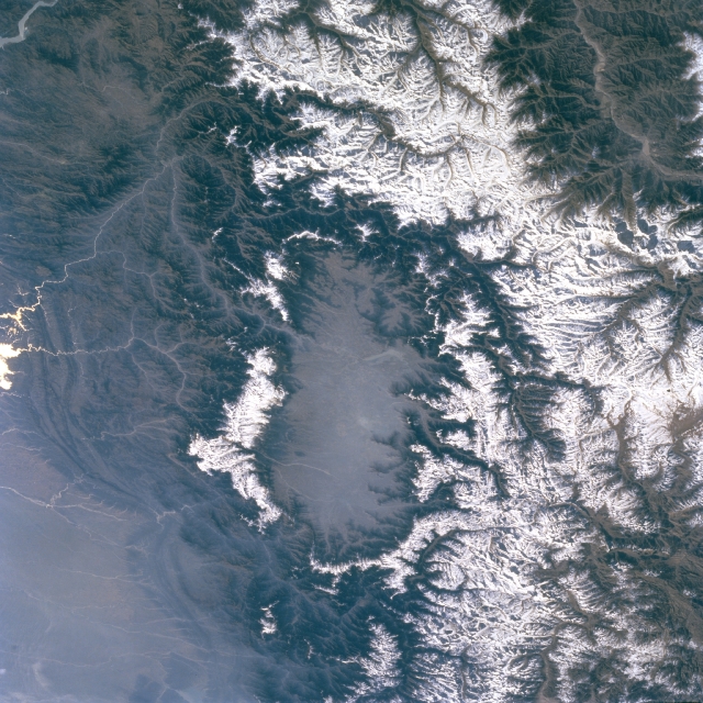
خلاصہ
| تفصیل | Kashmir Valley bordered by Karakorm Range in the north, Zanskar Range in the east and Pir Panjal Range in the west and south. |
| تریخ | before ۲ اپریل ۲۰۰۹ |
| سروت | http://eol.jsc.nasa.gov/sseop/EFS/images.pl?photo=STS066-127-79 |
| لکھاری | NASA |
لائسنس –
| This file is in the public domain in the United States because it was solely created by NASA. NASA copyright policy states that "NASA material is not protected by copyright unless noted". (See Template:PD-USGov, NASA copyright policy page or JPL Image Use Policy.) | ||
 |
Warnings:
|
پہلا اپلوڈ دا ریکارڈ
The original description page was here. All following user names refer to en.wikipedia.
- 2009-04-01 06:02 Doorvery far 640×640× (438485 bytes) Public domain nasa image: http://eol.jsc.nasa.gov/sseop/EFS/images.pl?photo=STS066-127-79
فائل دی تریخ
فائل نو اس ویلے دی حالت وچ ویکھن واسطے تاریخ/ویلے تے کلک کرو۔
| تریخ تے ویلہ | نکی مورت | پاسے | ورتن والا | تیپّݨی کرو | |
|---|---|---|---|---|---|
| موجودہ | ۲۰:۴۵, ۱۷ مئی ۲۰۱۱ | | ۶۴۰ × ۶۴۰ (۴۲۸ کلوبائٹ) | Woudloper | {{Information |Description={{en|Public domain NASA image: http://eol.jsc.nasa.gov/sseop/EFS/images.pl?photo=STS066-127-79}} |Source=Transferred from [http://en.wikipedia.org en.wikipedia] |Date={{Date|2009|04|01}} (original upload date) |Author=Original u |
فائل دی ورتوں
تھلے دتے گئے 1 صفحے اس فائل نال جُڑدے نیں
فائل ویاپک ورتوں
ایہہ دوجے وکیاں ایس فائل نوں ورتدے نیں –
- be.wikipedia.org تے ورتوں
- bh.wikipedia.org تے ورتوں
- bn.wikipedia.org تے ورتوں
- de.wikipedia.org تے ورتوں
- de.wikivoyage.org تے ورتوں
- dty.wikipedia.org تے ورتوں
- en.wikipedia.org تے ورتوں
- en.wikivoyage.org تے ورتوں
- es.wikipedia.org تے ورتوں
- fa.wikipedia.org تے ورتوں
- frr.wikipedia.org تے ورتوں
- fr.wikipedia.org تے ورتوں
- fr.wikinews.org تے ورتوں
- fr.wikivoyage.org تے ورتوں
- gu.wikipedia.org تے ورتوں
- he.wikipedia.org تے ورتوں
- hi.wikipedia.org تے ورتوں
- id.wikipedia.org تے ورتوں
- ja.wikipedia.org تے ورتوں
- kn.wikipedia.org تے ورتوں
- ko.wikipedia.org تے ورتوں
- ks.wikipedia.org تے ورتوں
- ml.wikipedia.org تے ورتوں
- mr.wikipedia.org تے ورتوں
- ms.wikipedia.org تے ورتوں
- ne.wikipedia.org تے ورتوں
- nl.wikipedia.org تے ورتوں
- nn.wikipedia.org تے ورتوں
- os.wikipedia.org تے ورتوں
- pa.wikipedia.org تے ورتوں
- pl.wikipedia.org تے ورتوں
- ru.wikipedia.org تے ورتوں
- ru.wikinews.org تے ورتوں
- sa.wikipedia.org تے ورتوں
- simple.wikipedia.org تے ورتوں
- sl.wikipedia.org تے ورتوں
- sv.wikipedia.org تے ورتوں
ایس فائل دا ویکھو ہور جگت ورتن .