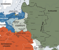
فائل:Karte kongresspolen.png

ایس وکھالے دا ناپ: ۷۰۱ × ۵۹۹ پکسلز۔ دوجے ریزولوشنز: ۲۸۱ × ۲۴۰ پکسلز | ۵۶۲ × ۴۸۰ پکسلز | ۸۹۶ × ۷۶۶ پکسلز ۔
اصل فائل (۸۹۶ × ۷۶۶ پکسلز, فائل حجم: ۶۰۲ کلوبائٹ, MIME type: image/png)
فائل دی تریخ
فائل نو اس ویلے دی حالت وچ ویکھن واسطے تاریخ/ویلے تے کلک کرو۔
| تریخ تے ویلہ | نکی مورت | پاسے | ورتن والا | تیپّݨی کرو | |
|---|---|---|---|---|---|
| موجودہ | ۱۶:۴۷, ۵ اپریل ۲۰۲۴ |  | ۸۹۶ × ۷۶۶ (۶۰۲ کلوبائٹ) | Claude Zygiel | The original is incorrect because it represents Austria-Hungary which was not founded until 1867, while Congress Poland was created in 1815 at the Congress of Vienna. It would be better to avoid being obsessed with Transylvania which has nothing to do with this. Julieta, Zygiel (who are not blocked) absolutely do not want to "remove" Transylvania nor separate it from Hungary in historical maps but on the contrary to represent it (knowing perfectly well that it was ruled by the Hungarian nobil... |
| ۲۰:۴۶, ۱۶ فروری ۲۰۲۴ |  | ۸۹۶ × ۷۶۶ (۶۲۱ کلوبائٹ) | OrionNimrod | Restore original. If this is Österreich-Ungarn (Austria-Hungary) which estbalished in 1867, Transylvania was integral part of Hungary, and I do not see other county borders. Blocked Julieta and Zygiel want all the time remove Transylvania from Hungary in historical maps by Romanian nationalistic purpose, example: https://commons.wikimedia.org/wiki/Commons:Deletion_requests/File:Europe_1097-corrected.jpg | |
| ۱۴:۴۱, ۱۳ جنوری ۲۰۲۴ |  | ۸۹۶ × ۷۶۶ (۶۰۲ کلوبائٹ) | Claude Zygiel | This is not a master painting or an artist's photo. It is a digital map of history and it would be desirable to stop restoring erroneous versions. At least read the talk page, it was created for that. | |
| ۲۱:۲۲, ۱۶ نومبر ۲۰۲۲ |  | ۹۰۰ × ۷۷۰ (۴۴۲ کلوبائٹ) | Gyalu22 | Other countries also don't have administrative division borders | |
| ۲۳:۲۵, ۸ جون ۲۰۲۲ |  | ۸۹۶ × ۷۶۶ (۶۰۲ کلوبائٹ) | Claude Zygiel | Reverted to version as of 23:17, 15 October 2016 (UTC) : please see Discussion file. | |
| ۰۳:۴۰, ۸ اپریل ۲۰۲۱ |  | ۹۰۰ × ۷۷۰ (۴۴۲ کلوبائٹ) | JohnVanVliet | jpg artifact removal | |
| ۰۴:۱۷, ۱۶ اکتوبر ۲۰۱۶ |  | ۸۹۶ × ۷۶۶ (۶۰۲ کلوبائٹ) | The Real The Z | Wiederherstellung des ẞ (großen Eszetts) in der Karte. Die vorherige Version ersetzte das ẞ mit einem ß, obwohl es bei diesem Upload darum geht, dass die Karte ein ẞ enthält, und nicht ein SS/SZ/ß. | |
| ۱۰:۴۹, ۱۵ اکتوبر ۲۰۱۶ |  | ۱,۳۴۴ × ۱,۱۴۹ (۴۹۴ کلوبائٹ) | Jiangkm3 | Higher Resolution | |
| ۱۹:۳۴, ۶ مئی ۲۰۱۶ |  | ۸۹۶ × ۷۶۶ (۶۰۲ کلوبائٹ) | Julieta39 | Kleine kosmetische Hinzufügen | |
| ۲۳:۰۹, ۲۵ مئی ۲۰۱۰ |  | ۸۹۶ × ۷۶۶ (۶۲۱ کلوبائٹ) | Ras67 | cropped, watermark removed |
فائل دی ورتوں
تھلے دتے گئے 2 صفحے اس فائل نال جُڑدے نیں
فائل ویاپک ورتوں
ایہہ دوجے وکیاں ایس فائل نوں ورتدے نیں –
- als.wikipedia.org تے ورتوں
- an.wikipedia.org تے ورتوں
- ast.wikipedia.org تے ورتوں
- bat-smg.wikipedia.org تے ورتوں
- be-tarask.wikipedia.org تے ورتوں
- be.wikipedia.org تے ورتوں
- br.wikipedia.org تے ورتوں
- ca.wikipedia.org تے ورتوں
- cs.wikipedia.org تے ورتوں
- da.wikipedia.org تے ورتوں
- de.wikipedia.org تے ورتوں
- en.wikipedia.org تے ورتوں
- eo.wikipedia.org تے ورتوں
- es.wikipedia.org تے ورتوں
- et.wikipedia.org تے ورتوں
- fr.wikipedia.org تے ورتوں
- gl.wikipedia.org تے ورتوں
- he.wikipedia.org تے ورتوں
- hr.wikipedia.org تے ورتوں
- hu.wikipedia.org تے ورتوں
- it.wikipedia.org تے ورتوں
- ka.wikipedia.org تے ورتوں
- lt.wikibooks.org تے ورتوں
- lv.wikipedia.org تے ورتوں
- nl.wikipedia.org تے ورتوں
ایس فائل دا ویکھو ہور جگت ورتن .

