فائل:Kandahar districts.png

ایس وکھالے دا ناپ: ۷۸۶ × ۶۰۰ پکسلز۔ دوجے ریزولوشنز: ۳۱۵ × ۲۴۰ پکسلز | ۶۲۹ × ۴۸۰ پکسلز | ۱,۰۰۰ × ۷۶۳ پکسلز ۔
اصل فائل (۱,۰۰۰ × ۷۶۳ پکسلز, فائل حجم: ۳۰ کلوبائٹ, MIME type: image/png)

|
This locator map image could be re-created using vector graphics as an SVG file. This has several advantages; see Commons:Media for cleanup for more information. If an SVG form of this image is available, please upload it and afterwards replace this template with
{{vector version available|new image name}}.
It is recommended to name the SVG file “Kandahar districts.svg”—then the template Vector version available (or Vva) does not need the new image name parameter. |
خلاصہ

|
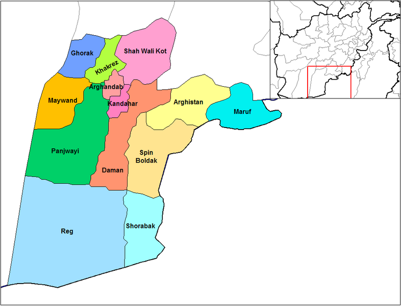
This file requires updating because: Does not include Miyanishin District or Zhari District. Miyanishin was created from the Northern part of Shah Wali Kot. Zhari was created from parts of Maywand and Panjwai In doing so, you could add a timestamp to the file.
|
English: Map of the districts of Kandahar province of Afghanistan. Created by Rarelibra 19:26, 29 March 2007 (UTC) for public domain use, using MapInfo Professional v8.5 and various mapping resources.
لائسنس –
| میں، اس کم دے کاپیرائٹ دا مالک، اس کم نوں لوکاں واسطے دیندا واں۔ اے سارے جگ واسطے لاگو اے۔ کج ملکاں چ قانونی طور تے اے ممکن نئیں اے؛ اگر انج ای اے ے: میں ہر کسے نوں اس کم نوں کسے وی مقصد واسطے ورتن دا بغیر کسے شرط دے حق دیندا واں، اگر اوہ قانون دے خلاف نا ہوۓ۔ |
فائل دی تریخ
فائل نو اس ویلے دی حالت وچ ویکھن واسطے تاریخ/ویلے تے کلک کرو۔
| تریخ تے ویلہ | نکی مورت | پاسے | ورتن والا | تیپّݨی کرو | |
|---|---|---|---|---|---|
| موجودہ | ۱۹:۴۷, ۱۵ فروری ۲۰۲۴ | | ۱,۰۰۰ × ۷۶۳ (۳۰ کلوبائٹ) | User-duck | Cropped 5 % horizontally, 6 % vertically using CropTool with lossless mode. |
| ۰۰:۲۶, ۳۰ مارچ ۲۰۰۷ |  | ۱,۰۵۶ × ۸۱۶ (۳۰ کلوبائٹ) | Rarelibra | Map of the districts of Kandahar province of Afghanistan. Created by ~~~~ for public domain use, using MapInfo Professional v8.5 and various mapping resources. |
فائل دی ورتوں
تھلے دتے گئے 1 صفحے اس فائل نال جُڑدے نیں
فائل ویاپک ورتوں
ایہہ دوجے وکیاں ایس فائل نوں ورتدے نیں –
- ar.wikipedia.org تے ورتوں
- bn.wikipedia.org تے ورتوں
- ca.wikipedia.org تے ورتوں
- da.wikipedia.org تے ورتوں
- de.wikipedia.org تے ورتوں
- en.wikipedia.org تے ورتوں
- en.wikinews.org تے ورتوں
- es.wikipedia.org تے ورتوں
- et.wikipedia.org تے ورتوں
- fr.wikipedia.org تے ورتوں
- he.wikipedia.org تے ورتوں
- incubator.wikimedia.org تے ورتوں
- it.wikipedia.org تے ورتوں
- ja.wikipedia.org تے ورتوں
- lt.wikipedia.org تے ورتوں
- mn.wikipedia.org تے ورتوں
- ms.wikipedia.org تے ورتوں
- nl.wikipedia.org تے ورتوں
ایس فائل دا ویکھو ہور جگت ورتن .