فائل:Italy c 1810.png
ایس وکھالے دا ناپ: ۴۱۳ × ۵۹۹ پکسلز۔ دوجے ریزولوشنز: ۱۶۵ × ۲۴۰ پکسلز | ۳۳۱ × ۴۸۰ پکسلز | ۵۲۹ × ۷۶۸ پکسلز | ۱,۲۵۱ × ۱,۸۱۴ پکسلز ۔
اصل فائل (۱,۲۵۱ × ۱,۸۱۴ پکسلز, فائل حجم: ۹۰ کلوبائٹ, MIME type: image/png)
خلاصہ
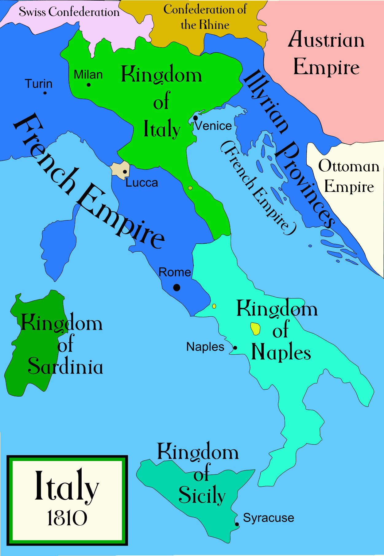
Political map of Italy in the years around 1810, during the Napoleonic era, created by MapMaster. This is a companion map to Image:Italy 1796.png and Image:Italy 1494_v2.png. An SVG version of this map (with Slovenian labels) can be found at Image:Italija_1810_Slovenscina.svg.
Spanish version: File:Italy c 1810-es.png, uploaded by Aibdescalzo

|
This historical map image could be re-created using vector graphics as an SVG file. This has several advantages; see Commons:Media for cleanup for more information. If an SVG form of this image is available, please upload it and afterwards replace this template with
{{vector version available|new image name}}.
It is recommended to name the SVG file “Italy c 1810.svg”—then the template Vector version available (or Vva) does not need the new image name parameter. |
References
- Bjorklund, Oddvar; Holmboe, Haakon; Rohr, Anders (1970) Historical Atlas of the World, Barnes & Noble, NY, SBN: 389-00253-4.
- Other maps, including Image:1french-empire1811.jpg from the 1912 Cambridge Modern History Atlas.
لائسنس –
میں، اس کم دے کاپیرائٹ دا مالک، اس کم نوں اس لائسنس دے مطابق چھاپدا واں:

|
کاپی کرن، ونڈن تے بدلن دی ایس ڈوکومنٹ لئی اجازت دتی جاندی اے ایہناں GNU Free Documentation License, Version 1.2 شرطاں نال یا مگروں کسے وی چھپے ورین Free Software Foundation توں بنا کسے انویرینٹ سیکشن دے، ناں فرنٹ کور لکھت تے ناں بیک کور لکھت دے۔ لسنس دی اک کاپی سیکشن وچ ہیگی اے جہدا ناں اے GNU Free Documentation License۔ |
| ایس فائل نوں کریٹو کامنز Attribution 2.5 پولینڈ لائسنس دتا گیا. | ||
| ||
| اس لائسنس دا ٹیگ GFDL دے مطابق اس فائل چ پایا گیا اے licensing update۔ |
تسیں اپنی مرضی دا لائسنس چݨ سکدے اوہ۔
derivative works
Derivative works of this file:
[]
-
 Arabic
 -
 English
 -
 Spanish
 -
 Korean


فائل دی تریخ
فائل نو اس ویلے دی حالت وچ ویکھن واسطے تاریخ/ویلے تے کلک کرو۔
| تریخ تے ویلہ | نکی مورت | پاسے | ورتن والا | تیپّݨی کرو | |
|---|---|---|---|---|---|
| موجودہ | ۰۶:۳۲, ۲۱ اپریل ۲۰۰۹ | | ۱,۲۵۱ × ۱,۸۱۴ (۹۰ کلوبائٹ) | Capmo | pallette reduction to 64 colours |
| ۰۹:۰۱, ۱۹ اکتوبر ۲۰۰۶ |  | ۱,۲۵۱ × ۱,۸۱۴ (۳۸۵ کلوبائٹ) | MapMaster | Further improvements to bring it into line with Image:Italy 1796.png | |
| ۱۷:۴۱, ۱۳ اکتوبر ۲۰۰۶ |  | ۱,۲۵۱ × ۱,۸۱۴ (۴۰۳ کلوبائٹ) | MapMaster | Map was slightly improved. | |
| ۱۷:۰۰, ۱۳ اکتوبر ۲۰۰۶ |  | ۱,۲۶۵ × ۱,۸۱۶ (۴۰۲ کلوبائٹ) | MapMaster | Political map of Italy in the years around 1810, during the Napoleonic era, created by MapMaster. |
فائل دی ورتوں
تھلے دتے گئے 1 صفحے اس فائل نال جُڑدے نیں
فائل ویاپک ورتوں
ایہہ دوجے وکیاں ایس فائل نوں ورتدے نیں –
- an.wikipedia.org تے ورتوں
- be.wikipedia.org تے ورتوں
- br.wikipedia.org تے ورتوں
- ca.wikipedia.org تے ورتوں
- ceb.wikipedia.org تے ورتوں
- cs.wikipedia.org تے ورتوں
- da.wikipedia.org تے ورتوں
- de.wikipedia.org تے ورتوں
- en.wikipedia.org تے ورتوں
- eo.wikipedia.org تے ورتوں
- es.wikipedia.org تے ورتوں
- et.wikipedia.org تے ورتوں
- fa.wikipedia.org تے ورتوں
- fr.wikipedia.org تے ورتوں
- he.wikipedia.org تے ورتوں
- hi.wikipedia.org تے ورتوں
- hr.wikipedia.org تے ورتوں
- hu.wikipedia.org تے ورتوں
- id.wikipedia.org تے ورتوں
- is.wikipedia.org تے ورتوں
- it.wikipedia.org تے ورتوں
- ja.wikipedia.org تے ورتوں
ایس فائل دا ویکھو ہور جگت ورتن .