فائل:Island of Ireland location map Clare.svg

Size of this PNG preview of this SVG file: ۴۸۱ × ۵۹۹ پکسلز. دوجے ریزولوشنز: ۱۹۲ × ۲۴۰ پکسلز | ۳۸۵ × ۴۸۰ پکسلز | ۶۱۶ × ۷۶۸ پکسلز | ۸۲۲ × ۱,۰۲۴ پکسلز | ۱,۶۴۳ × ۲,۰۴۸ پکسلز | ۱,۴۵۰ × ۱,۸۰۷ پکسلز ۔
اصل فائل (ایس وی جی فائل، پکسل:۱,۴۵۰ × ۱,۸۰۷، فائل سائز: ۶۴۲ کلوبائٹ)
| تفصیل |
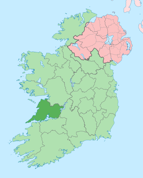
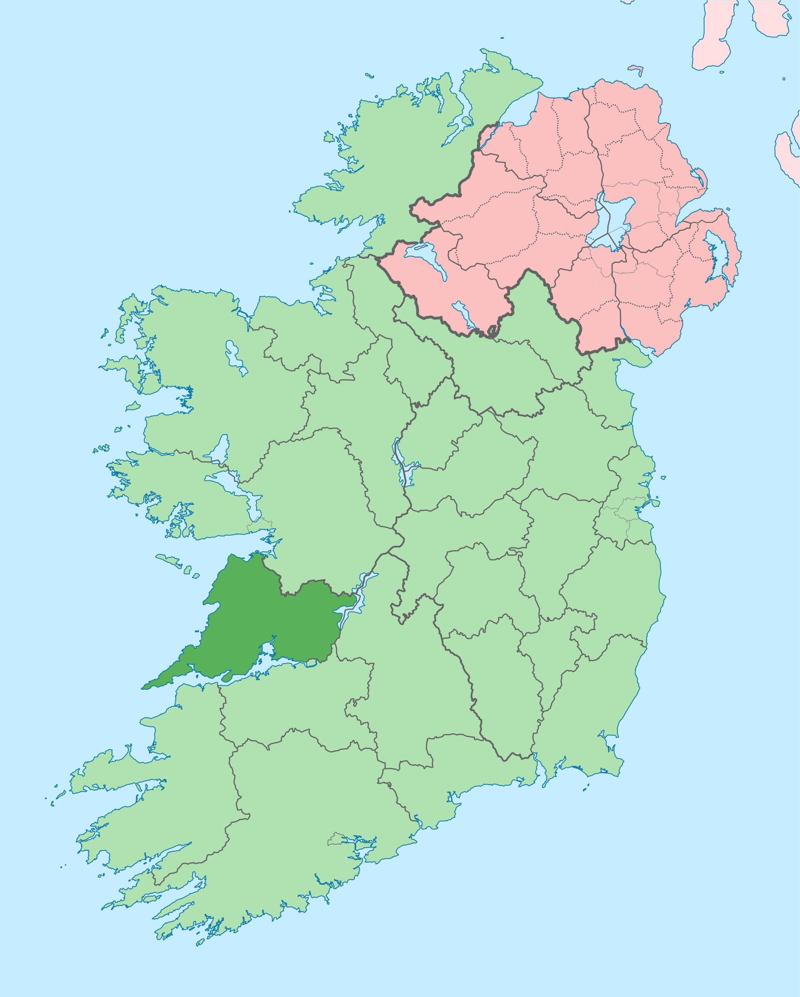
English: The island of Ireland, showing international border between Ireland and Northern Ireland, traditional provinces, traditional counties, and local authority areas in Ireland and Northern Ireland. |
| تریخ | (UTC) |
| سروت | |
| لکھاری |
|
| This is a retouched picture, which means that it has been digitally altered from its original version. Modifications: Coloured in regions with county of article highlighted. The original can be viewed here: Island of Ireland location map.svg:
|
میں، اس کم دے کاپیرائٹ دا مالک، اس کم نوں اس لائسنس دے مطابق چھاپدا واں:
ایس فائل نوں کریٹو کامنز Attribution 2.5 پولینڈ لائسنس دتا گیا.
- تہانوں کھلھ اے:
- حصہ کرنا – کاپی، ونڈنا تے کم بھیجنا
- فیر رلانا – کم نوں فٹ کرنا
- تھلے دتیاں شرطاں نال:
- کس دے ناں – تسیں لازمی ایس کم دے بناں والے بارے دسو جنج اونے آکھیا اے یا جنج لسنس چ آکھیا گیا ہے۔
- اکو جہا شئیر کرو۔ – اگر تسیں بدلدے یا ایس کم تے بناندے تے بنن والے کم نوں اینج دے لسنس نال ای ونڈو گے۔
پہلا اپلوڈ دا ریکارڈ
This image is a derivative work of the following images:
- File:Island_of_Ireland_location_map.svg licensed with Cc-by-sa-3.0
- 2010-03-06T20:43:33Z Rannpháirtí anaithnid 1450x1807 (679207 Bytes) Fix incorrectly coloured isands.
- 2010-03-03T22:19:29Z Rannpháirtí anaithnid 1450x1807 (679744 Bytes) {{Information |Description={{de|Positionskarte von [[:de:Irland|Irland]]}} Quadratische Plattkarte, N-S-Streckung 170 %. Geographische Begrenzung der Karte: * N: 55.6° N * S: 51.2° N * W: 11.0° W * O: 5.0° W {{en|Location
Uploaded with derivativeFX
فائل دی تریخ
فائل نو اس ویلے دی حالت وچ ویکھن واسطے تاریخ/ویلے تے کلک کرو۔
| تریخ تے ویلہ | نکی مورت | پاسے | ورتن والا | تیپّݨی کرو | |
|---|---|---|---|---|---|
| موجودہ | ۱۹:۰۵, ۲۸ جون ۲۰۲۰ | | ۱,۴۵۰ × ۱,۸۰۷ (۶۴۲ کلوبائٹ) | Chipmunkdavis | Colouring in Aughinish |
| ۲۰:۵۴, ۲۶ جون ۲۰۲۰ |  | ۱,۴۵۰ × ۱,۸۰۷ (۶۴۲ کلوبائٹ) | Chipmunkdavis | Rmv stray number in code | |
| ۲۰:۲۶, ۲۶ جون ۲۰۲۰ |  | ۱,۴۵۰ × ۱,۸۰۷ (۶۴۲ کلوبائٹ) | Chipmunkdavis | Merging Tipperary and Waterford shapes | |
| ۱۷:۵۵, ۲۶ جون ۲۰۲۰ |  | ۱,۴۵۰ × ۱,۸۰۷ (۶۴۳ کلوبائٹ) | Chipmunkdavis | Removing Limerick City | |
| ۲۱:۲۱, ۲۵ جون ۲۰۲۰ |  | ۱,۴۵۰ × ۱,۸۰۷ (۶۴۳ کلوبائٹ) | Chipmunkdavis | Per the Local Government Reform Act 2014, removing the Tipperary border and the Waterford City border. | |
| ۲۱:۱۰, ۲۵ جون ۲۰۲۰ |  | ۱,۴۵۰ × ۱,۸۰۷ (۶۴۶ کلوبائٹ) | Chipmunkdavis | Removing lots of stray objects. Fixing location of Clare and one island slightly. | |
| ۲۰:۴۵, ۲۵ جون ۲۰۲۰ |  | ۱,۴۵۰ × ۱,۸۰۷ (۶۹۵ کلوبائٹ) | Chipmunkdavis | Colour islands in, place all islands and borders in groups, remove some blank and redundant shapes | |
| ۰۵:۴۱, ۱۹ جولائی ۲۰۱۰ |  | ۱,۴۵۰ × ۱,۸۰۷ (۸۱۵ کلوبائٹ) | Mabuska | {{Information |Description={{en|The island of Ireland, showing international border between Northern Ireland and Republic of Ireland, traditional provinces, traditional counties, and local authority areas in the Republic of Ireland and Northern Ireland.}} |
فائل دی ورتوں
تھلے دتے گئے 1 صفحے اس فائل نال جُڑدے نیں
فائل ویاپک ورتوں
ایہہ دوجے وکیاں ایس فائل نوں ورتدے نیں –
- ar.wikipedia.org تے ورتوں
- ast.wikipedia.org تے ورتوں
- bg.wikipedia.org تے ورتوں
- ca.wikipedia.org تے ورتوں
- ceb.wikipedia.org تے ورتوں
- cs.wikipedia.org تے ورتوں
- en.wikipedia.org تے ورتوں
- County Clare
- Inagh
- Ennis
- List of Ireland-related topics
- Shannon, County Clare
- Lissycasey
- Shannon Free Zone
- Lisdoonvarna
- Cratloe
- Doolin
- Kilfenora
- Ballyvaughan
- Carran
- Kilkee
- Kilrush
- Clarecastle
- Ennistymon
- Killaloe, County Clare
- Lahinch
- Liscannor
- Mountshannon
- Newmarket-on-Fergus
- O'Brien's Bridge
- Spanish Point, County Clare
- Aughinish, County Clare
ایس فائل دا ویکھو ہور جگت ورتن .