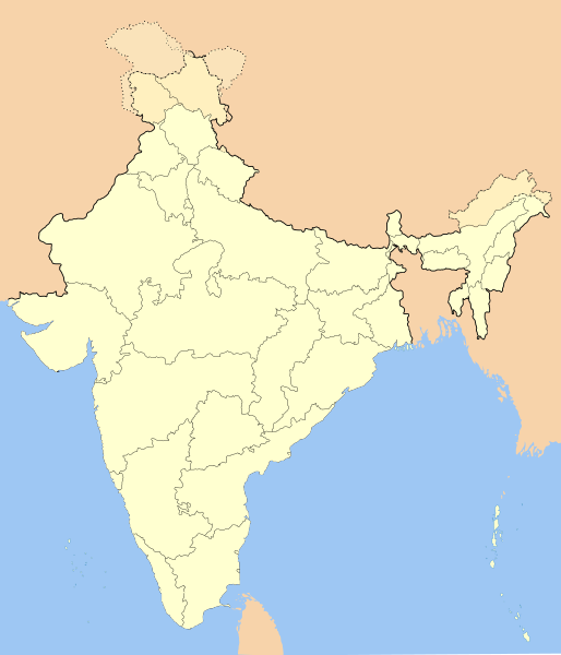
فائل:India-locator-map-blank.svg

Size of this PNG preview of this SVG file: ۵۱۴ × ۶۰۰ پکسلز. دوجے ریزولوشنز: ۲۰۶ × ۲۴۰ پکسلز | ۴۱۱ × ۴۸۰ پکسلز | ۶۵۸ × ۷۶۸ پکسلز | ۸۷۷ × ۱,۰۲۴ پکسلز | ۱,۷۵۵ × ۲,۰۴۸ پکسلز | ۱,۴۸۶ × ۱,۷۳۴ پکسلز ۔
اصل فائل (ایس وی جی فائل، پکسل:۱,۴۸۶ × ۱,۷۳۴، فائل سائز: ۲۵۲ کلوبائٹ)
فائل دی تریخ
فائل نو اس ویلے دی حالت وچ ویکھن واسطے تاریخ/ویلے تے کلک کرو۔
| تریخ تے ویلہ | نکی مورت | پاسے | ورتن والا | تیپّݨی کرو | |
|---|---|---|---|---|---|
| موجودہ | ۱۹:۰۱, ۱۴ اکتوبر ۲۰۲۰ |  | ۱,۴۸۶ × ۱,۷۳۴ (۲۵۲ کلوبائٹ) | NordNordWest | upd Telangana/Andhra Pradesh |
| ۲۲:۴۸, ۲۵ جولائی ۲۰۲۰ |  | ۱,۴۸۶ × ۱,۷۳۴ (۲۵۲ کلوبائٹ) | NordNordWest | Jammu and Kashmir/Ladakh | |
| ۰۶:۴۲, ۱ اپریل ۲۰۱۷ |  | ۱,۴۸۶ × ۱,۷۳۴ (۳۳۷ کلوبائٹ) | Utcursch | Moved Telangana to states layer | |
| ۱۹:۰۸, ۲۹ جنوری ۲۰۱۶ |  | ۱,۴۸۶ × ۱,۷۳۴ (۳۷۹ کلوبائٹ) | Csyogi | Telangana update | |
| ۲۰:۳۶, ۱۶ مئی ۲۰۰۶ |  | ۱,۴۸۶ × ۱,۷۳۴ (۴۲۱ کلوبائٹ) | Nichalp | Siachen edits | |
| ۱۷:۴۹, ۱۳ مئی ۲۰۰۶ |  | ۱,۴۸۶ × ۱,۷۳۴ (۴۲۴ کلوبائٹ) | Nichalp | Siachen correction | |
| ۱۷:۴۳, ۱۳ مئی ۲۰۰۶ |  | ۱,۴۸۶ × ۱,۷۳۴ (۴۲۲ کلوبائٹ) | Nichalp | border changes | |
| ۱۰:۵۳, ۹ مئی ۲۰۰۶ |  | ۱,۴۸۶ × ۱,۷۳۴ (۴۲۱ کلوبائٹ) | Nichalp | Updates as suggested in FPC | |
| ۱۲:۴۸, ۷ مئی ۲۰۰۶ |  | ۱,۴۸۶ × ۱,۷۳۴ (۴۲۱ کلوبائٹ) | Nichalp | Version 2; added some additional disputed areas in the Western sector | |
| ۲۳:۲۷, ۶ مئی ۲۰۰۶ |  | ۱,۴۸۶ × ۱,۷۳۴ (۴۱۶ کلوبائٹ) | Nichalp | Blank locator map of India SVG Map drawn by me, ~~~~ category:Maps of India |
فائل دی ورتوں
تھلے دتے گئے 20 صفحے اس فائل نال جُڑدے نیں
فائل ویاپک ورتوں
ایہہ دوجے وکیاں ایس فائل نوں ورتدے نیں –
- as.wikipedia.org تے ورتوں
- as.wikiquote.org تے ورتوں
- awa.wikipedia.org تے ورتوں
- खाँचा:ज्ञानसन्दूक भारत कय क्षेत्र
- भारत कय राज्य
- भारत कय संघ राज्यक्षेत्र
- खाँचा:India States and Territories Labelled Map
- खाँचा:Infobox Indian Jurisdiction
- खाँचा:Infobox Indian Jurisdiction/Examples/city
- खाँचा:Infobox Indian Jurisdiction/Examples/district
- खाँचा:Infobox Indian Jurisdiction/Examples/neighbourhood
- खाँचा:Infobox Indian Jurisdiction/Examples/protected area
- खाँचा:Infobox Indian Jurisdiction/Examples/state
- खाँचा:Infobox Indian Jurisdiction/Examples/suburb
- खाँचा:Infobox Indian Jurisdiction/Examples/town
- खाँचा:Infobox Indian Jurisdiction/Examples/village
- खाँचा:Infobox Indian Jurisdiction/Sandbox
- खाँचा:Infobox Indian Jurisdiction/Sandbox/doc
- खाँचा:Infobox Indian Jurisdiction/doc
- खाँचा:ज्ञानसन्दूक भारत कय क्षेत्र/doc
- सीधी
- ban.wikipedia.org تے ورتوں
- bn.wikipedia.org تے ورتوں
- bpy.wikipedia.org تے ورتوں
ایس فائل دا ویکھو ہور جگت ورتن .

