فائل:Holy Roman Empire 1648.svg

Size of this PNG preview of this SVG file: ۷۵۶ × ۵۹۹ پکسلز. دوجے ریزولوشنز: ۳۰۳ × ۲۴۰ پکسلز | ۶۰۶ × ۴۸۰ پکسلز | ۹۶۹ × ۷۶۸ پکسلز | ۱,۲۸۰ × ۱,۰۱۵ پکسلز | ۲,۵۶۰ × ۲,۰۳۰ پکسلز | ۲,۲۸۳ × ۱,۸۱۰ پکسلز ۔
اصل فائل (ایس وی جی فائل، پکسل:۲,۲۸۳ × ۱,۸۱۰، فائل سائز: ۳.۰۷ میگابائٹ)
خلاصہ
| تفصیل |
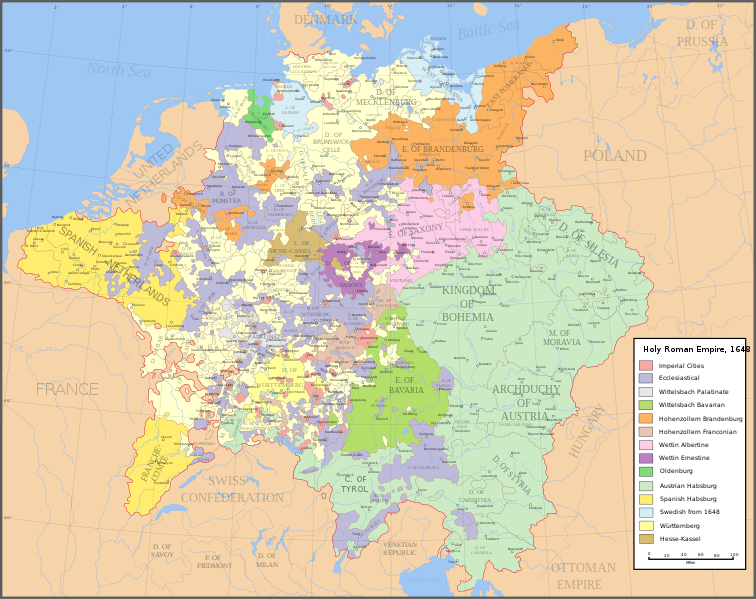
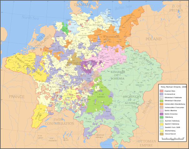
English: Map of the Holy Roman Empire in 1648, after the Peace of Westphalia which ended the Thirty Years' War. Deutsch: Karte des Heiligen Römischen Reiches 1648, nach dem Westfälischer Friede, der den Dreißigjähriger Krieg beendete. Français : Carte du Saint-Empire à 1648, après la paix de Westphalie qui mettent fin à la guerre de Trente Ans. Version française est disponible à File:Holy Roman Empire 1648 fr.svg. Српски / srpski: Мапа Светог римског царства у 1648, након Вестфалског мира којим је завршен Тридесетогодишњи рат.
|
English | Deutsch | Français | Српски |
||
|---|---|---|---|---|---|
| A | Archbishopric | Erzbistum | Archevêché | АДИЈ. | Архидијецеза |
| B | Bishopric | Bistum | Évêché | ДИЈ. | Дијецеза |
| C | County | Grafschaft | Comté | ОКР./ГРОФ. | Округ/грофовија |
| D | Duchy | Herzogtum | Duché | ВОЈВ. | Војводство |
| E | Electorate | Kurfürstentum | Électorat | ЕЛЕКТ. | Електорат |
| L | Landgraviate | Landgrafschaft | Landgraviat | ЛГРОФ. | Ландгрофовија |
| M | Margraviate | Markgrafschaft | Margraviat | МГРОФ. | Маркгрофовија |
| P | Principality | Fürstentum | Principauté | ГРОФ./ОКР. | Грофовија/округ |
Legend / Farblegende / Légende / Легенда
English | Deutsch | Français | Српски |
|
|---|---|---|---|---|
Palatinat des Wittelsbach |
||||
Wittelsbach Bavaria |
Wittelsbacher Bayern |
Bavière des Wittelsbach |
Вителсбах, баварски | |
Hohenzollern Franconia |
Hohenzollerner Franken |
Хоенцолерн, франконски | ||
Wettin Ernestine Saxony |
Wettiner Ernestiner Sachsen |
Saxe de la branche ernestine des Wettin |
Ветин, ернестински | |
Made from the public domain map "Central Europe about 1648" from the Historical Atlas by William R. Shepherd, at the Perry-Castañeda Library Map Collection at the University of Texas. Further information from Overy, Richard, 2006, The Times Complete history of the world Times Books ISBN 0007181299, and from this map
See also other maps at external links:
- Central Europe 1648
- Map on personal site, Europe in 1648
- Treaty of Westphalia
- 1648 map of Prussia
- Britannica, Spanish domains in 1648
This W3C-unspecified vector image was created with Inkscape .
(فائل نوں دوبارہ ورتنا)

|
کاپی کرن، ونڈن تے بدلن دی ایس ڈوکومنٹ لئی اجازت دتی جاندی اے ایہناں GNU Free Documentation License, Version 1.2 شرطاں نال یا مگروں کسے وی چھپے ورین Free Software Foundation توں بنا کسے انویرینٹ سیکشن دے، ناں فرنٹ کور لکھت تے ناں بیک کور لکھت دے۔ لسنس دی اک کاپی سیکشن وچ ہیگی اے جہدا ناں اے GNU Free Documentation License۔ |
| ایس فائل نوں کریٹو کامنز Attribution 2.5 پولینڈ لائسنس دتا گیا. | ||
| ||
| اس لائسنس دا ٹیگ GFDL دے مطابق اس فائل چ پایا گیا اے licensing update۔ |
[]
-
 English SVG
 -
 Spanish SVG
 -
 French SVG
 -
 Georgian SVG
 -
 Serbian SVG
 -
 English: Blank PNG
 -
 English PNG
 -
 Spanish PNG
 -
 Serbian PNG
 -
 Russian PNG


|
This SVG file contains embedded text that can be translated into your language, using any capable SVG editor, text editor or the SVG Translate tool. For more information see: About translating SVG files. |
فائل دی تریخ
فائل نو اس ویلے دی حالت وچ ویکھن واسطے تاریخ/ویلے تے کلک کرو۔
| تریخ تے ویلہ | نکی مورت | پاسے | ورتن والا | تیپّݨی کرو | |
|---|---|---|---|---|---|
| موجودہ | ۰۱:۴۳, ۲۵ جولائی ۲۰۲۲ | | ۲,۲۸۳ × ۱,۸۱۰ (۳.۰۷ میگابائٹ) | Maproom | ZWEIBRCKEN -> ZWEIBRÜCKEN, Treves -> Trier, Liege -> Liège |
| ۲۲:۵۵, ۱۸ مئی ۲۰۲۲ |  | ۲,۲۸۳ × ۱,۸۱۰ (۳.۰۷ میگابائٹ) | Maproom | Consistent, and German, spelling of "Mainz" | |
| ۰۱:۱۱, ۲۶ مئی ۲۰۲۱ |  | ۲,۲۸۳ × ۱,۸۱۰ (۳.۰۷ میگابائٹ) | ElCet | added the biggest city of Upper Silesia back then | |
| ۱۶:۳۴, ۲۳ مارچ ۲۰۱۸ |  | ۲,۲۸۳ × ۱,۸۱۰ (۳.۰۱ میگابائٹ) | Valentinian | Cleanup some names including missing umlauts. Brunswick-Lüneburg -> Brunswick-Celle (see talk). Border north of Rendsburg seems slightly off to me and the situation in Holstein is rather simplified (jointly administered areas are missing). | |
| ۰۰:۰۹, ۹ اکتوبر ۲۰۱۰ |  | ۲,۲۸۳ × ۱,۸۱۰ (۳.۰۱ میگابائٹ) | Joostik | Ravenstein as part of Cleves | |
| ۰۰:۴۵, ۱۰ اگست ۲۰۰۹ |  | ۲,۲۸۳ × ۱,۸۱۰ (۳.۰۱ میگابائٹ) | Ysangkok | simplify code (save as plain svg) | |
| ۱۴:۲۴, ۱۴ جولائی ۲۰۰۹ |  | ۲,۲۸۳ × ۱,۸۱۰ (۴.۱۷ میگابائٹ) | Roke~commonswiki | Zusmarshausen | |
| ۲۰:۱۶, ۲۰ اپریل ۲۰۰۷ |  | ۲,۲۸۳ × ۱,۸۱۰ (۴.۱۲ میگابائٹ) | Roke~commonswiki | ||
| ۰۷:۰۴, ۲۰ اپریل ۲۰۰۷ |  | ۲,۲۸۳ × ۱,۸۱۰ (۴.۱۱ میگابائٹ) | Roke~commonswiki | rm HRE text, darken labels | |
| ۰۸:۰۴, ۱۸ اپریل ۲۰۰۷ |  | ۲,۲۸۳ × ۱,۸۱۰ (۴.۱۱ میگابائٹ) | Roke~commonswiki |
فائل دی ورتوں
تھلے دتے گئے 1 صفحے اس فائل نال جُڑدے نیں
فائل ویاپک ورتوں
ایہہ دوجے وکیاں ایس فائل نوں ورتدے نیں –
- af.wikipedia.org تے ورتوں
- azb.wikipedia.org تے ورتوں
- az.wikipedia.org تے ورتوں
- br.wikipedia.org تے ورتوں
- ca.wikipedia.org تے ورتوں
- ckb.wikipedia.org تے ورتوں
- cs.wikipedia.org تے ورتوں
- el.wikipedia.org تے ورتوں
- en.wikipedia.org تے ورتوں
- Peace of Westphalia
- Thirty Years' War
- Germans
- Wikipedia:WikiProject Maps
- Imperial Estate
- Talk:Paul Skalich
- Treaty of Fontainebleau (1631)
- Wikipedia:Featured picture candidates/Holy Roman Empire in 1648
- Wikipedia:Featured picture candidates/May-2007
- User talk:Giano II/archive 7
- User:Luosiji/Sandbox
- User:Jammydodger/HRE
- Germany in the early modern period
- User:Zealotzuo/Sandbox
- Wikipedia talk:WikiProject Maps/Archive 5
- Territorial evolution of France
- User:Oaholroyd/sandbox
- User:JMvanDijk/Sandbox 10
- User:DyinRich/Something Else
- Aftermath of the Eighty Years' War
- eo.wikipedia.org تے ورتوں
- et.wikipedia.org تے ورتوں
- fa.wikipedia.org تے ورتوں
- fi.wikipedia.org تے ورتوں
- fy.wikipedia.org تے ورتوں
- hu.wikipedia.org تے ورتوں
- hy.wikipedia.org تے ورتوں
- id.wikipedia.org تے ورتوں
- it.wikipedia.org تے ورتوں
ایس فائل دا ویکھو ہور جگت ورتن .