فائل:Han Dynasty map 2CE.png
اس توں وڈی مورت موجود نہیں۔
Han_Dynasty_map_2CE.png (۵۵۰ × ۳۸۲ پکسلز, فائل حجم: ۴۰ کلوبائٹ, MIME type: image/png)
خلاصہ
| تفصیل |
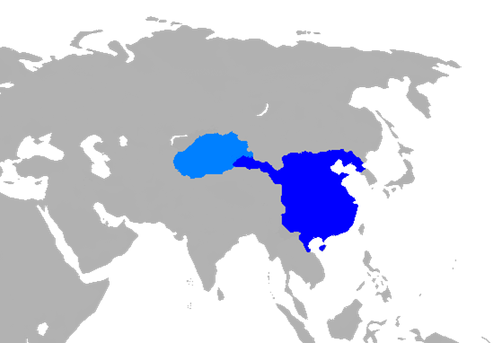
English: Map of Han Dynasty in 2 CE.
|
||
| تریخ | |||
| سروت |
Own work using:
|
||
| لکھاری | User:Historian of the arab people | ||
| دوجے ورژن |
|

لائسنس –
| میں، اس کم دے کاپیرائٹ دا مالک، اس کم نوں لوکاں واسطے دیندا واں۔ اے سارے جگ واسطے لاگو اے۔ کج ملکاں چ قانونی طور تے اے ممکن نئیں اے؛ اگر انج ای اے ے: میں ہر کسے نوں اس کم نوں کسے وی مقصد واسطے ورتن دا بغیر کسے شرط دے حق دیندا واں، اگر اوہ قانون دے خلاف نا ہوۓ۔ |
فائل دی تریخ
فائل نو اس ویلے دی حالت وچ ویکھن واسطے تاریخ/ویلے تے کلک کرو۔
| تریخ تے ویلہ | نکی مورت | پاسے | ورتن والا | تیپّݨی کرو | |
|---|---|---|---|---|---|
| موجودہ | ۱۰:۵۱, ۶ جنوری ۲۰۱۹ | | ۵۵۰ × ۳۸۲ (۴۰ کلوبائٹ) | 复旦大学张超 | add Hainan |
| ۰۹:۲۹, ۶ جنوری ۲۰۱۹ |  | ۵۱۱ × ۳۸۲ (۳۹ کلوبائٹ) | 复旦大学张超 | edit | |
| ۰۹:۲۰, ۶ جنوری ۲۰۱۹ |  | ۵۵۰ × ۳۸۲ (۴۰ کلوبائٹ) | 复旦大学张超 | User created page with UploadWizard |
فائل دی ورتوں
تھلے دتے گئے 1 صفحے اس فائل نال جُڑدے نیں
فائل ویاپک ورتوں
ایہہ دوجے وکیاں ایس فائل نوں ورتدے نیں –
- bat-smg.wikipedia.org تے ورتوں
- cs.wikipedia.org تے ورتوں
- cv.wikipedia.org تے ورتوں
- en.wikipedia.org تے ورتوں
- es.wikipedia.org تے ورتوں
- fa.wikipedia.org تے ورتوں
- fr.wikipedia.org تے ورتوں
- gn.wikipedia.org تے ورتوں
- id.wikipedia.org تے ورتوں
- ja.wikipedia.org تے ورتوں
- ko.wikipedia.org تے ورتوں
- lld.wikipedia.org تے ورتوں
- mn.wikipedia.org تے ورتوں
- ms.wikipedia.org تے ورتوں
- mt.wikipedia.org تے ورتوں
- ru.wikipedia.org تے ورتوں
- si.wikipedia.org تے ورتوں
- sl.wikipedia.org تے ورتوں
- sq.wikipedia.org تے ورتوں
- sr.wikipedia.org تے ورتوں
- th.wikipedia.org تے ورتوں
- tr.wikipedia.org تے ورتوں
- ur.wikipedia.org تے ورتوں
- vi.wikipedia.org تے ورتوں