فائل:GulfofMexico3D.jpg

ایس وکھالے دا ناپ: ۷۳۴ × ۶۰۰ پکسلز۔ دوجے ریزولوشنز: ۲۹۴ × ۲۴۰ پکسلز | ۵۸۸ × ۴۸۰ پکسلز | ۹۴۰ × ۷۶۸ پکسلز | ۱,۲۵۳ × ۱,۰۲۴ پکسلز | ۲,۵۰۷ × ۲,۰۴۸ پکسلز | ۳,۰۰۰ × ۲,۴۵۱ پکسلز ۔
اصل فائل (۳,۰۰۰ × ۲,۴۵۱ پکسلز, فائل حجم: ۵۰۸ کلوبائٹ, MIME type: image/jpeg)
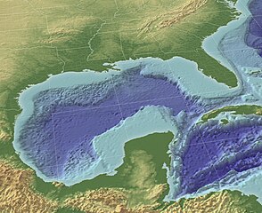
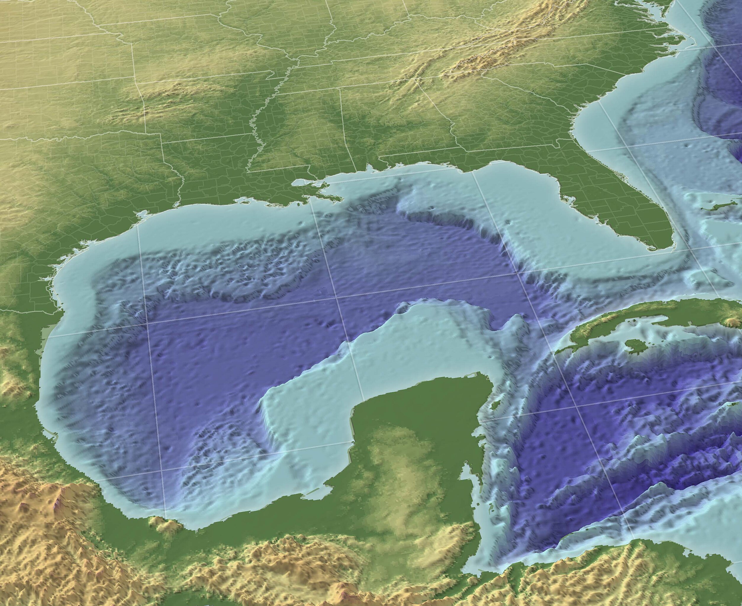
"The Gulf of Mexico in 3D perspective. A GIS can create very accurate and realistic-looking environments." Source (High-Res: 3000x2451).
This image is in the public domain because it contains materials that originally came from the U.S. National Oceanic and Atmospheric Administration, taken or made as part of an employee's official duties.
|
From English wikipedia w:en:Image:GulfofMexico3D.png
فائل دی تریخ
فائل نو اس ویلے دی حالت وچ ویکھن واسطے تاریخ/ویلے تے کلک کرو۔
| تریخ تے ویلہ | نکی مورت | پاسے | ورتن والا | تیپّݨی کرو | |
|---|---|---|---|---|---|
| موجودہ | ۱۵:۳۰, ۱۳ نومبر ۲۰۰۹ | | ۳,۰۰۰ × ۲,۴۵۱ (۵۰۸ کلوبائٹ) | Justass | resolution |
| ۲۳:۳۶, ۱۹ مئی ۲۰۰۵ |  | ۱,۰۲۴ × ۸۳۷ (۵۴۵ کلوبائٹ) | Gengiskanhg | "The Gulf of Mexico in 3D perspective. A GIS can create very accurate and realistic-looking environments." [http://oceanexplorer.noaa.gov/technology/tools/mapping/media/GulfofMexico.jpg Source] (High-Res: 3000x2451). {{PD-USGov-NOAA}} From US wikipedia |
فائل دی ورتوں
تھلے دتے گئے 1 صفحے اس فائل نال جُڑدے نیں
فائل ویاپک ورتوں
ایہہ دوجے وکیاں ایس فائل نوں ورتدے نیں –
- af.wikipedia.org تے ورتوں
- an.wikipedia.org تے ورتوں
- ar.wikipedia.org تے ورتوں
- ast.wikipedia.org تے ورتوں
- avk.wikipedia.org تے ورتوں
- azb.wikipedia.org تے ورتوں
- az.wikipedia.org تے ورتوں
- az.wiktionary.org تے ورتوں
- ba.wikipedia.org تے ورتوں
- be-tarask.wikipedia.org تے ورتوں
- be.wikipedia.org تے ورتوں
- br.wikipedia.org تے ورتوں
- bs.wikipedia.org تے ورتوں
- ca.wikipedia.org تے ورتوں
- ce.wikipedia.org تے ورتوں
- cs.wikipedia.org تے ورتوں
- cv.wikipedia.org تے ورتوں
- cy.wikipedia.org تے ورتوں
- da.wikipedia.org تے ورتوں
- de.wikipedia.org تے ورتوں
- en.wikipedia.org تے ورتوں
- en.wikibooks.org تے ورتوں
- en.wikinews.org تے ورتوں
- en.wiktionary.org تے ورتوں
- eo.wikipedia.org تے ورتوں
- es.wikipedia.org تے ورتوں
ایس فائل دا ویکھو ہور جگت ورتن .