فائل:Golan heights rel89-orig.jpg

ایس وکھالے دا ناپ: ۴۷۴ × ۵۹۹ پکسلز۔ دوجے ریزولوشنز: ۱۹۰ × ۲۴۰ پکسلز | ۳۸۰ × ۴۸۰ پکسلز | ۹۷۴ × ۱,۲۳۱ پکسلز ۔
اصل فائل (۹۷۴ × ۱,۲۳۱ پکسلز, فائل حجم: ۲۴۵ کلوبائٹ, MIME type: image/jpeg)
| تفصیل |
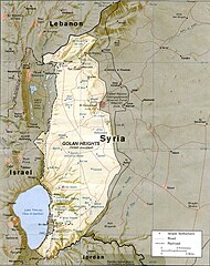
English: CIA map of the Golan Heights showing Israeli settlements and Syrian villages as of 1989 |
|||
| تریخ | ||||
| سروت | http://www.lib.utexas.edu/maps/middle_east_and_asia/golan_heights_rel89.jpg | |||
| لکھاری | CIA | |||
| اجازت (فائل نوں دوبارہ ورتنا) |
|

فائل دی تریخ
فائل نو اس ویلے دی حالت وچ ویکھن واسطے تاریخ/ویلے تے کلک کرو۔
| تریخ تے ویلہ | نکی مورت | پاسے | ورتن والا | تیپّݨی کرو | |
|---|---|---|---|---|---|
| موجودہ | ۲۰:۱۵, ۷ جولائی ۲۰۰۹ | | ۹۷۴ × ۱,۲۳۱ (۲۴۵ کلوبائٹ) | Nableezy | {{Information |Description={{en|1=CIA map of the Golan Height showing Israeli settlements and Syrian villages as of 1989}} |Source=http://www.lib.utexas.edu/maps/middle_east_and_asia/golan_heights_rel89.jpg |Author=CIA |Date=1989 |Permission={{PD-USGov-CI |
فائل دی ورتوں
تھلے دتے گئے 1 صفحے اس فائل نال جُڑدے نیں
فائل ویاپک ورتوں
ایہہ دوجے وکیاں ایس فائل نوں ورتدے نیں –
- ar.wikipedia.org تے ورتوں
- arz.wikipedia.org تے ورتوں
- be-tarask.wikipedia.org تے ورتوں
- bg.wikipedia.org تے ورتوں
- ca.wikipedia.org تے ورتوں
- csb.wikipedia.org تے ورتوں
- cs.wikipedia.org تے ورتوں
- da.wikipedia.org تے ورتوں
- en.wikipedia.org تے ورتوں
- es.wikipedia.org تے ورتوں
- fy.wikipedia.org تے ورتوں
- hi.wikipedia.org تے ورتوں
- hy.wikipedia.org تے ورتوں
- id.wikipedia.org تے ورتوں
- incubator.wikimedia.org تے ورتوں
- it.wikipedia.org تے ورتوں
- ka.wikipedia.org تے ورتوں
- lt.wikipedia.org تے ورتوں
- ms.wikipedia.org تے ورتوں
- nl.wikipedia.org تے ورتوں
- nn.wikipedia.org تے ورتوں
- no.wikipedia.org تے ورتوں
- pl.wikipedia.org تے ورتوں
- pt.wikibooks.org تے ورتوں
- ru.wikipedia.org تے ورتوں
- uk.wikipedia.org تے ورتوں
- vi.wikipedia.org تے ورتوں
- www.wikidata.org تے ورتوں
- xmf.wikipedia.org تے ورتوں
- zh.wikipedia.org تے ورتوں