فائل:Gibraltar map-en-edit2.svg

Size of this PNG preview of this SVG file: ۳۸۵ × ۶۰۰ پکسلز. دوجے ریزولوشنز: ۱۵۴ × ۲۴۰ پکسلز | ۳۰۸ × ۴۸۰ پکسلز | ۴۹۳ × ۷۶۸ پکسلز | ۶۵۷ × ۱,۰۲۴ پکسلز | ۱,۳۱۴ × ۲,۰۴۸ پکسلز | ۱,۰۰۰ × ۱,۵۵۸ پکسلز ۔
اصل فائل (ایس وی جی فائل، پکسل:۱,۰۰۰ × ۱,۵۵۸، فائل سائز: ۱.۴۶ میگابائٹ)
خلاصہ
|
This W3C-unspecified vector image was created with Inkscape .
| Camera location | | View this and other nearby images on: OpenStreetMap |
|---|
| تفصیل |
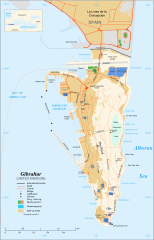
English: Map in English of Gibraltar
Français : Carte en anglais de Gibraltar |
| تریخ | |
| سروت |
English: adapted from: Image:Gibraltar map-en.svg
Français : Création personnelle ;
|
| لکھاری | Original by Eric Gaba (Sting), label/legend edits by Jeff Dahl |
| اجازت (فائل نوں دوبارہ ورتنا) |
Attribution and Share-Alike required |
| دوجے ورژن |
|


|
This SVG file contains embedded text that can be translated into your language, using any capable SVG editor, text editor or the SVG Translate tool. For more information see: About translating SVG files. |
لائسنس –
میں، اس کم دے کاپیرائٹ دا مالک، اس کم نوں اس لائسنس دے مطابق چھاپدا واں:

|
کاپی کرن، ونڈن تے بدلن دی ایس ڈوکومنٹ لئی اجازت دتی جاندی اے ایہناں GNU Free Documentation License, Version 1.2 شرطاں نال یا مگروں کسے وی چھپے ورین Free Software Foundation توں بنا کسے انویرینٹ سیکشن دے، ناں فرنٹ کور لکھت تے ناں بیک کور لکھت دے۔ لسنس دی اک کاپی سیکشن وچ ہیگی اے جہدا ناں اے GNU Free Documentation License۔ |
This file is licensed under the Creative Commons Attribution-Share Alike 4.0 International, 3.0 Unported, 2.5 Generic, 2.0 Generic and 1.0 Generic license.
- تہانوں کھلھ اے:
- حصہ کرنا – کاپی، ونڈنا تے کم بھیجنا
- فیر رلانا – کم نوں فٹ کرنا
- تھلے دتیاں شرطاں نال:
- کس دے ناں – تسیں لازمی ایس کم دے بناں والے بارے دسو جنج اونے آکھیا اے یا جنج لسنس چ آکھیا گیا ہے۔
- اکو جہا شئیر کرو۔ – اگر تسیں بدلدے یا ایس کم تے بناندے تے بنن والے کم نوں اینج دے لسنس نال ای ونڈو گے۔
تسیں اپنی مرضی دا لائسنس چݨ سکدے اوہ۔
فائل دی تریخ
فائل نو اس ویلے دی حالت وچ ویکھن واسطے تاریخ/ویلے تے کلک کرو۔
| تریخ تے ویلہ | نکی مورت | پاسے | ورتن والا | تیپّݨی کرو | |
|---|---|---|---|---|---|
| موجودہ | ۲۱:۳۶, ۵ اپریل ۲۰۱۷ | | ۱,۰۰۰ × ۱,۵۵۸ (۱.۴۶ میگابائٹ) | RaviC | + University, Ferry terminal (& Route), Cathedral |
| ۲۳:۵۲, ۱۱ دسمبر ۲۰۰۷ |  | ۱,۰۰۰ × ۱,۵۵۸ (۱.۷۹ میگابائٹ) | Jeff Dahl | resized 1200 down to 1000px wide, minor label fixes | |
| ۲۲:۰۸, ۱۰ دسمبر ۲۰۰۷ |  | ۱,۲۰۰ × ۱,۸۷۰ (۱.۷۸ میگابائٹ) | Jeff Dahl | {{inkscape}} {{Location|36|08|00|N|5|21|00|W|type:city_scale:50000}} {{Information |Description=Map in English of Gibraltar |Source=adapted from: Image:Gibraltar map-en.svg <br/>Map created using screenshots of [[:en:Google Ea |
فائل دی ورتوں
تھلے دتے گئے 1 صفحے اس فائل نال جُڑدے نیں
فائل ویاپک ورتوں
ایہہ دوجے وکیاں ایس فائل نوں ورتدے نیں –
- af.wikipedia.org تے ورتوں
- ar.wikipedia.org تے ورتوں
- av.wikipedia.org تے ورتوں
- azb.wikipedia.org تے ورتوں
- bg.wikipedia.org تے ورتوں
- bn.wikipedia.org تے ورتوں
- bs.wikipedia.org تے ورتوں
- ceb.wikipedia.org تے ورتوں
- Plantilya:Location map Gibraltar
- Signal Hill
- White Rock
- Sandy Bay
- Roca Blanca
- Ailsa Craig
- Passage Point
- El Peñón
- The Rock
- Middle Hill
- Gibraltar (pagklaro)
- Rock of Gibraltar
- Deadmans Beach
- Eastern Beach
- Western Beach
- Punta Pasaje
- Punta Europa
- La Roca
- Governor’s Beach
- Camp Bay
- Europa Point
- Gibraltar Bay
- Cerro de Enmedio
- Blackstrap Bay
- Caledonian Canal
- Great Europa Point
- Gibilterra
- White Rock (bato sa Gyibraltar)
- Western Beach (lapyahan sa Gyibraltar)
- Signal Hill (bungtod sa Gyibraltar)
- Sandy Bay North
- Sandy Bay (luuk)
- Saint Michael's Cave
- Saint Abb's Head
- North Gorge
- Middle Hill (bungtod sa Gyibraltar)
- Mediterranean Steps
- Martin's Cave
- Europa Point (punta sa Gyibraltar)
- The Lido
- Levant Cave
- H.M.S. Rooke
ایس فائل دا ویکھو ہور جگت ورتن .