فائل:Gains territoriaux de la France en 1814.svg

Size of this PNG preview of this SVG file: ۶۳۲ × ۶۰۰ پکسلز. دوجے ریزولوشنز: ۲۵۳ × ۲۴۰ پکسلز | ۵۰۶ × ۴۸۰ پکسلز | ۸۰۹ × ۷۶۸ پکسلز | ۱,۰۷۹ × ۱,۰۲۴ پکسلز | ۲,۱۵۸ × ۲,۰۴۸ پکسلز | ۲,۰۰۰ × ۱,۸۹۸ پکسلز ۔
اصل فائل (ایس وی جی فائل، پکسل:۲,۰۰۰ × ۱,۸۹۸، فائل سائز: ۳۱۴ کلوبائٹ)
خلاصہ
| تفصیل |
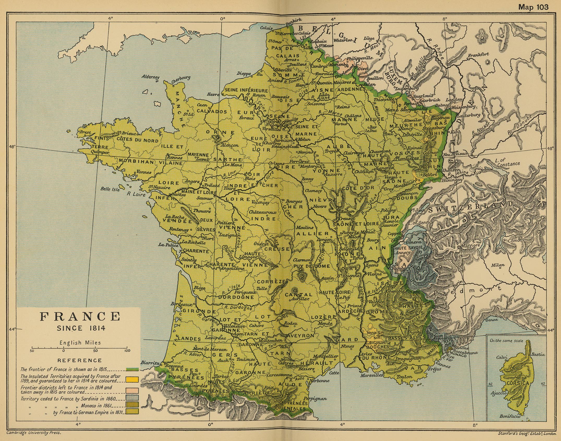
English: Blank map of France in 1814, with territories obtained with the 1814 Treaty of Paris (in red), but lost with the 1815 Treaty of Paris.
Français : Carte vierge de la France en 1814, avec en rouge les territoires obtenus par le Traité de Paris de 1814, mais perdus après le Traité de Paris de 1815, après l'épisode des 100 jours. Lambert-93 projection ; RGF-93 datum Scale: 1:2,000,000 |
| تریخ | (UTC) |
| سروت |
|
| لکھاری |
|
| دوجے ورژن | |
| کس دے ناں (required by the license) | © Sémhur / Wikimedia Commons / |
| SVG | W3C-validity not checked. |
| Graphic Lab |
| Camera location | | View this and other nearby images on: OpenStreetMap |
|---|
لائسنس –
میں، اس کم دے کاپیرائٹ دا مالک، اس کم نوں اس لائسنس دے مطابق چھاپدا واں:
| کاپی حق چھڈیا: آرٹ دا ایہ کم کھلا اے؛ تسیں اینوں ونڈ سکدے او یا بدل سکدے او Free Art License دیاں شرطاں نال۔ تسیں ایدے لسنس دی اک ادھارن Copyleft Attitude site تے Copyleft Attitude site تے ہور سائیٹاں تے لب سکدے او |
This file is licensed under the Creative Commons Attribution-Share Alike 4.0 International, 3.0 Unported, 2.5 Generic, 2.0 Generic and 1.0 Generic license.
- تہانوں کھلھ اے:
- حصہ کرنا – کاپی، ونڈنا تے کم بھیجنا
- فیر رلانا – کم نوں فٹ کرنا
- تھلے دتیاں شرطاں نال:
- کس دے ناں – تسیں لازمی ایس کم دے بناں والے بارے دسو جنج اونے آکھیا اے یا جنج لسنس چ آکھیا گیا ہے۔
- اکو جہا شئیر کرو۔ – اگر تسیں بدلدے یا ایس کم تے بناندے تے بنن والے کم نوں اینج دے لسنس نال ای ونڈو گے۔
تسیں اپنی مرضی دا لائسنس چݨ سکدے اوہ۔
پہلا اپلوڈ دا ریکارڈ
This image is a derivative work of the following images:
- File:France_map_Lambert-93_with_regions_and_departments-blank.svg licensed with Cc-by-sa-3.0,2.5,2.0,1.0, GFDL
- 2008-11-13T17:38:21Z Sting 2000x1898 (885358 Bytes) + boundary for Channel Islands
- 2008-10-01T04:50:15Z Sting 2000x1898 (883528 Bytes) == Summary == {{Location|46|15|00|N|02|06|00|E|scale:10000000}} {{Information |Description={{en|Blank map of [[:en:France|France]] in the official Lambert-93 projection, with regions and departments boundaries.}} {{fr|Carte
Uploaded with derivativeFX
فائل دی تریخ
فائل نو اس ویلے دی حالت وچ ویکھن واسطے تاریخ/ویلے تے کلک کرو۔
| تریخ تے ویلہ | نکی مورت | پاسے | ورتن والا | تیپّݨی کرو | |
|---|---|---|---|---|---|
| موجودہ | ۲۲:۴۰, ۸ فروری ۲۰۱۴ | | ۲,۰۰۰ × ۱,۸۹۸ (۳۱۴ کلوبائٹ) | Sémhur | == {{int:filedesc}} == {{Information |Description= {{en|Blank map of France in 1814, with territories obtained with the 1814 Treaty of Paris (in red), but lost with the 1815 Treaty of Paris. }} {{fr|Carte vierge de la [[:fr:France|Franc... |
فائل دی ورتوں
تھلے دتے گئے 1 صفحے اس فائل نال جُڑدے نیں
فائل ویاپک ورتوں
ایہہ دوجے وکیاں ایس فائل نوں ورتدے نیں –
- ca.wikipedia.org تے ورتوں
- de.wikipedia.org تے ورتوں
- en.wikipedia.org تے ورتوں
- fr.wikipedia.org تے ورتوں
- hi.wikipedia.org تے ورتوں
- it.wikipedia.org تے ورتوں
- mk.wikipedia.org تے ورتوں
- nl.wikipedia.org تے ورتوں
- ro.wikipedia.org تے ورتوں
- ur.wikipedia.org تے ورتوں
- vi.wikipedia.org تے ورتوں
- zh.wikipedia.org تے ورتوں