اصل فائل(۵۷۵ × ۷۹۲ پکسلز, فائل حجم: ۳۱ کلوبائٹ, MIME type: image/gif)

ایہ فائل Wikimedia Commons توں اے تے دوجیاں ویونتاں تے وی ورتی جاسکدی اے۔ گل بات اس دے فائل گل بات صفحہ تے تھلے دتی گئی۔

This map image could be re-created using vector graphics as an SVG file. This has several advantages; see Commons:Media for cleanup for more information. If an SVG form of this image is available, please upload it and afterwards replace this template with {{vector version available|new image name}}.


It is recommended to name the SVG file “First century Iudaea province.svg”—then the template Vector version available (or Vva) does not need the new image name parameter.

خلاصہ

تفصیل
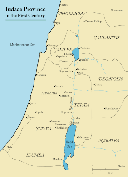
English: This is a map of first century Iudaea Province that I created using Illustrator CS2. I traced this image for the general geographic features. I then manually input data from maps found in a couple of sources.
  • Robert W. Funk and the Jesus Seminar. The Acts of Jesus. HarperSanFrancisco: 1998. p. xxiv.
  • Michael Grant. Jesus: An Historian's Review of the Gospels. Charles Scribner's Sons: 1977. p. 65-67.
  • John P. Meier. A Marginal Jew. Doubleday: 1991. p. 1:434.
تریخ ۲۳ مارچ ۲۰۰۶ (original upload date)
سروت Transferred from en.wikipedia to Commons.
لکھاری Andrew c at English وکیپیڈیا
اجازت
(فائل نوں دوبارہ ورتنا)
Released under the GNU Free Documentation License or CC-BY.
دوجے ورژن العربيَّة

لائسنس –

Andrew c from en.wikipedia.org، اس کم دے کاپیرائٹ دا مالک، اس کم نوں اس لائسنس دے مطابق چھاپدا واں:
GNU head کاپی کرن، ونڈن تے بدلن دی ایس ڈوکومنٹ ل‏ئی اجازت دتی جاندی اے ایہناں GNU Free Documentation License, Version 1.2 شرطاں نال یا مگروں کسے وی چھپے ورین Free Software Foundation توں بنا کسے انویرینٹ سیکشن دے، ناں فرنٹ کور لکھت تے ناں بیک کور لکھت دے۔ لسنس دی اک کاپی سیکشن وچ ہیگی اے جہدا ناں اے GNU Free Documentation License۔ Subject to disclaimers.
w:en:Creative Commons
کس دے ناں
ایس فائل نوں کریٹو کامنز Attribution 3.0 انپورٹڈ لائسنس دتا گیا.
کس دے ناں: Wikipedia User:Andrew c
تہانوں کھلھ اے:
  • حصہ کرنا – کاپی، ونڈنا تے کم بھیجنا
  • فیر رلانا – کم نوں فٹ کرنا
تھلے دتیاں شرطاں نال:
  • کس دے ناں – تسیں لازمی ایس کم دے بناں والے بارے دسو جنج اونے آکھیا اے یا جنج لسنس چ آکھیا گیا ہے۔
Public domain میں، اس کم دے کاپیرائٹ دا مالک، اس کم نوں لوکاں واسطے دیندا واں۔ اے سارے جگ واسطے لاگو اے۔
کج ملکاں چ قانونی طور تے اے ممکن نئیں اے؛ اگر انج ای اے ے:
میں ہر کسے نوں اس کم نوں کسے وی مقصد واسطے ورتن دا بغیر کسے شرط دے حق دیندا واں، اگر اوہ قانون دے خلاف نا ہوۓ۔

پہلا اپلوڈ دا ریکارڈ

The original description page was here. All following user names refer to en.wikipedia.
  • 2006-03-24 18:48 Andrew c 575×792×8 (32374 bytes) This is a map of First Century Palestine that I created using Illustrator CS2. I traced [http://commons.wikimedia.org/wiki/Image:Map_of_administrative_regions_in_Israel.png this] image for the general geographic features. I then manually input data from m
  • 2006-03-23 19:48 Andrew c 587×790×8 (30752 bytes) This is a map of First Century Palestine that I created using Illustrator CS2. I traced [http://commons.wikimedia.org/wiki/Image:Map_of_administrative_regions_in_Israel.png this] image for the general geographic features. I then manually input data from m

Captions

Add a one-line explanation of what this file represents
Judaea province in the 1st Century CE

Items portrayed in this file

چترن

۲۳ مارچ 2006

MIME type English

image/gif

checksum English

e488e0183049d2138c916ccc7a24c107807f12b7

determination method English: ؜SHA-1 English

data size English

۳۲,۰۱۹ بائٹ

height English

۷۹۲ pixel

width English

۵۷۵ pixel

فائل دی تریخ

فائل نو اس ویلے دی حالت وچ ویکھن واسطے تاریخ/ویلے تے کلک کرو۔

تریخ تے ویلہنکی مورتپاسےورتن والاتیپّݨی کرو
موجودہ۱۶:۴۷, ۱۸ ستمبر ۲۰۱۱۱۶:۴۷, ۱۸ ستمبر ۲۰۱۱ ویلے دے ورژن ساتھ انگوٹھاکار روپ۵۷۵ × ۷۹۲ (۳۱ کلوبائٹ)OnceinawhileRemoved region-name "Philistia", as incorrect
۱۹:۰۵, ۱۳ ستمبر ۲۰۰۷۱۹:۰۵, ۱۳ ستمبر ۲۰۰۷ ویلے دے ورژن ساتھ انگوٹھاکار روپ۵۷۵ × ۷۹۲ (۳۲ کلوبائٹ)Liftarn{{SVG|map}} {{Information |Description=This is a map of first century en:Iudaea Province that I created using Illustrator CS2. I traced [http://commons.wikimedia.org/wiki/Image:Map_of_administrative_regions_in_Israel.png this] image for the general g
۰۵:۲۹, ۳۰ اپریل ۲۰۰۶۰۵:۲۹, ۳۰ اپریل ۲۰۰۶ ویلے دے ورژن ساتھ انگوٹھاکار روپ۵۷۵ × ۷۹۲ (۳۲ کلوبائٹ)Duende~commonswikihttp://en.wikipedia.org/wiki/Image:First_century_palestine.gif

تھلے دتے گئے 1 صفحے اس فائل نال جُڑدے نیں

فائل ویاپک ورتوں

ایہہ دوجے وکیاں ایس فائل نوں ورتدے نیں –

ایس فائل دا ویکھو ہور جگت ورتن .