فائل:Europe location WAL2.png

ایس وکھالے دا ناپ: ۸۰۰ × ۶۰۰ پکسلز۔ دوجے ریزولوشنز: ۳۲۰ × ۲۴۰ پکسلز | ۶۴۰ × ۴۸۰ پکسلز | ۱,۰۲۴ × ۷۶۸ پکسلز | ۱,۲۸۰ × ۹۶۰ پکسلز | ۱,۶۰۰ × ۱,۲۰۰ پکسلز ۔
اصل فائل (۱,۶۰۰ × ۱,۲۰۰ پکسلز, فائل حجم: ۸۰۳ کلوبائٹ, MIME type: image/png)
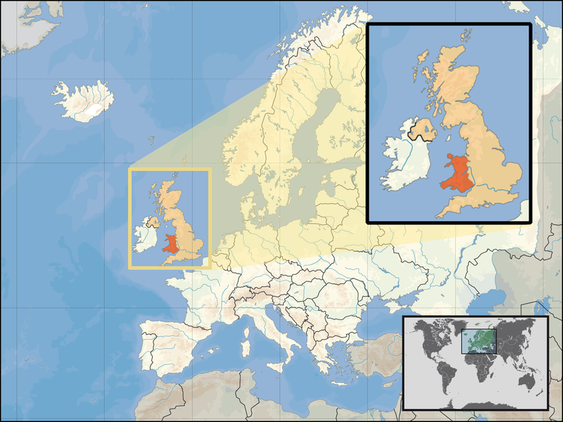
| تفصیل | Location of Wales in the UK and Europe, on terrain map showing surface and underwater contour areas. | |||
| تریخ | ||||
| سروت | Derived from Wikimedia Commons image of original work forming part of the "Europe location" map series created by David Liuzzo: derived from Image:Europe_location_WAL.png. | |||
| لکھاری | uploaded by User:Kmusser (excerpt from User:David_Liuzzo) | |||
| اجازت (فائل نوں دوبارہ ورتنا) |
|
|||
| دوجے ورژن |
|


فائل دی تریخ
فائل نو اس ویلے دی حالت وچ ویکھن واسطے تاریخ/ویلے تے کلک کرو۔
| تریخ تے ویلہ | نکی مورت | پاسے | ورتن والا | تیپّݨی کرو | |
|---|---|---|---|---|---|
| موجودہ | ۲۲:۲۰, ۲۴ ستمبر ۲۰۰۸ | | ۱,۶۰۰ × ۱,۲۰۰ (۸۰۳ کلوبائٹ) | Kmusser | {{Information |Description= Location of Wales in the UK and Europe, on terrain map showing surface and underwater contour areas. |Source=Derived from Wikimedia Commons image of original work forming part of the "Europe location" map series cre |
فائل دی ورتوں
تھلے دتے گئے 1 صفحے اس فائل نال جُڑدے نیں
فائل ویاپک ورتوں
ایہہ دوجے وکیاں ایس فائل نوں ورتدے نیں –
- an.wikipedia.org تے ورتوں
- ar.wikipedia.org تے ورتوں
- az.wiktionary.org تے ورتوں
- el.wikivoyage.org تے ورتوں
- en.wikipedia.org تے ورتوں
- eu.wiktionary.org تے ورتوں
- fo.wikipedia.org تے ورتوں
- gag.wikipedia.org تے ورتوں
- gom.wikipedia.org تے ورتوں
- gv.wikipedia.org تے ورتوں
- id.wikibooks.org تے ورتوں
- incubator.wikimedia.org تے ورتوں
- kaa.wikipedia.org تے ورتوں
- kn.wikipedia.org تے ورتوں
- la.wikipedia.org تے ورتوں
- mr.wikipedia.org تے ورتوں
- my.wikipedia.org تے ورتوں
- nds-nl.wikipedia.org تے ورتوں
- pl.wikipedia.org تے ورتوں
- pl.wikivoyage.org تے ورتوں
- pl.wiktionary.org تے ورتوں
- ru.wiktionary.org تے ورتوں
- su.wikipedia.org تے ورتوں
- ug.wikipedia.org تے ورتوں
- war.wikipedia.org تے ورتوں
- yo.wikipedia.org تے ورتوں
- zu.wikipedia.org تے ورتوں