فائل:Europe before Operation Barbarossa, 1941 (in German).png

ایس وکھالے دا ناپ: ۵۷۵ × ۵۹۹ پکسلز۔ دوجے ریزولوشنز: ۲۳۰ × ۲۴۰ پکسلز | ۴۶۱ × ۴۸۰ پکسلز | ۹۵۸ × ۹۹۸ پکسلز ۔
اصل فائل (۹۵۸ × ۹۹۸ پکسلز, فائل حجم: ۱۴۲ کلوبائٹ, MIME type: image/png)
خلاصہ
| تفصیل |
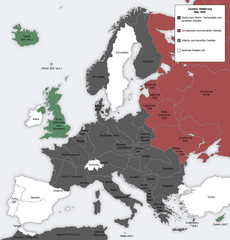
English: Map showing the Nazi, Finnish and Soviet-controlled borders of Europe by the end of May/beginning of June 1941, by the conclusion of the Nazi invasion of the Balkans and before Operation Barbarossa.
This PNG image, with captions in German, is derived from a frame from the GIF animation File:Second world war europe animation large de.gif at Wikimedia Commons. |
| تریخ | ۷ اپریل ۲۰۱۰ (original upload date) |
| سروت | Transferred from en.wikipedia to Commons. |
| لکھاری |
The original uploader was MaGioZal at English وکیپیڈیا.. Later version(s) were uploaded by DIREKTOR at en.wikipedia. |
| دوجے ورژن |
|
.png)
.png)
لائسنس –

|
کاپی کرن، ونڈن تے بدلن دی ایس ڈوکومنٹ لئی اجازت دتی جاندی اے ایہناں GNU Free Documentation License, Version 1.2 شرطاں نال یا مگروں کسے وی چھپے ورین Free Software Foundation توں بنا کسے انویرینٹ سیکشن دے، ناں فرنٹ کور لکھت تے ناں بیک کور لکھت دے۔ لسنس دی اک کاپی سیکشن وچ ہیگی اے جہدا ناں اے GNU Free Documentation License۔ |
| ایس فائل نوں کریٹو کامنز Attribution 2.5 پولینڈ لائسنس دتا گیا. | ||
| ||
| اس لائسنس دا ٹیگ GFDL دے مطابق اس فائل چ پایا گیا اے licensing update۔ |
پہلا اپلوڈ دا ریکارڈ
The original description page was here. All following user names refer to en.wikipedia.
- 2012-05-22 17:09 DIREKTOR 958×998× (200029 bytes) Colours
- 2010-04-07 01:43 MaGioZal 960×1000× (149500 bytes) Map showing the Nazi (darker blue) and Soviet-controlled (green) borders of Europe by the end of May/beginning of June [[1941]], after the [[Balkans Campaign|Nazi invasion of the Balkans]] and before [[Operation Barbarossa]]. This [[PNG image]], with cap
فائل دی تریخ
فائل نو اس ویلے دی حالت وچ ویکھن واسطے تاریخ/ویلے تے کلک کرو۔
| تریخ تے ویلہ | نکی مورت | پاسے | ورتن والا | تیپّݨی کرو | |
|---|---|---|---|---|---|
| موجودہ | ۲۳:۱۳, ۷ ستمبر ۲۰۱۲ | | ۹۵۸ × ۹۹۸ (۱۴۲ کلوبائٹ) | Illythr | Removed the "changes in the last frame" coloring, as there's only one frame here and the legend was misleading. |
| ۰۷:۰۹, ۱۶ اگست ۲۰۱۲ |  | ۹۵۸ × ۹۹۸ (۱۹۵ کلوبائٹ) | OgreBot | (BOT): Reverting to most recent version before archival | |
| ۰۷:۰۹, ۱۶ اگست ۲۰۱۲ |  | ۹۶۰ × ۱,۰۰۰ (۱۴۶ کلوبائٹ) | OgreBot | (BOT): Uploading old version of file from en.wikipedia; originally uploaded on 2010-04-07 01:43:08 by MaGioZal | |
| ۰۱:۰۴, ۲۳ جون ۲۰۱۲ |  | ۹۵۸ × ۹۹۸ (۱۹۵ کلوبائٹ) | Friedlibend und tapfer | {{Information |Description={{en|Map showing the Nazi and Soviet-controlled borders of Europe by the end of May/beginning of June 1941, by the conclusion of the Nazi invasion of the Balkans and before [[:en:Operatio... |
فائل دی ورتوں
تھلے دتے گئے 3 صفحے اس فائل نال جُڑدے نیں
فائل ویاپک ورتوں
ایہہ دوجے وکیاں ایس فائل نوں ورتدے نیں –
- af.wikipedia.org تے ورتوں
- ar.wikipedia.org تے ورتوں
- ast.wikipedia.org تے ورتوں
- azb.wikipedia.org تے ورتوں
- az.wikipedia.org تے ورتوں
- bg.wikipedia.org تے ورتوں
- bn.wikipedia.org تے ورتوں
- br.wikipedia.org تے ورتوں
- ca.wikipedia.org تے ورتوں
- cs.wikipedia.org تے ورتوں
- en.wikipedia.org تے ورتوں
- Continuation War
- Molotov–Ribbentrop Pact
- Operation Barbarossa
- Eastern Front (World War II)
- Balkans campaign (World War II)
- Interim Peace
- User:Dead Mary/sandbox6
- User:Dead Mary/sandbox7
- Presidency of Franklin D. Roosevelt, third and fourth terms
- Foreign policy of the Franklin D. Roosevelt administration
- User:Falcaorib
- eo.wikipedia.org تے ورتوں
- es.wikipedia.org تے ورتوں
- fi.wikipedia.org تے ورتوں
- hy.wikipedia.org تے ورتوں
- lt.wikipedia.org تے ورتوں
- lv.wikipedia.org تے ورتوں
- nl.wikipedia.org تے ورتوں
- pt.wikipedia.org تے ورتوں
- ru.wikipedia.org تے ورتوں
- ta.wikipedia.org تے ورتوں
- th.wikipedia.org تے ورتوں
- ur.wikipedia.org تے ورتوں
- zh.wikipedia.org تے ورتوں
.png)