فائل:English regions 2009.svg

Size of this PNG preview of this SVG file: ۴۹۴ × ۶۰۰ پکسلز. دوجے ریزولوشنز: ۱۹۸ × ۲۴۰ پکسلز | ۳۹۵ × ۴۸۰ پکسلز | ۶۳۳ × ۷۶۸ پکسلز | ۸۴۳ × ۱,۰۲۴ پکسلز | ۱,۶۸۷ × ۲,۰۴۸ پکسلز | ۱,۱۰۸ × ۱,۳۴۵ پکسلز ۔
اصل فائل (ایس وی جی فائل، پکسل:۱,۱۰۸ × ۱,۳۴۵، فائل سائز: ۳۶۵ کلوبائٹ)
خلاصہ
| تفصیل |
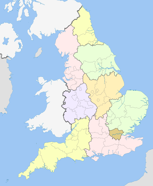
English: Map showing the Regions of England and the constituent metropolitan and non-metropolitan counties, in 2009.
Equirectangular map projection on WGS 84 datum, with N/S stretched 170% Geographic limits:
|
| تریخ | (UTC) |
| سروت |
This file was derived from: English metropolitan and non-metropolitan counties 2010.svg:  |
| لکھاری |
|
| This is a retouched picture, which means that it has been digitally altered from its original version. Modifications: recoloured with some thicker boundary lines. The original can be viewed here: English metropolitan and non-metropolitan counties 2010.svg:
|
لائسنس –
میں، اس کم دے کاپیرائٹ دا مالک، اس کم نوں اس لائسنس دے مطابق چھاپدا واں:
ایس فائل نوں کریٹو کامنز Attribution 2.5 پولینڈ لائسنس دتا گیا.
کس دے ناں: Nilfanion and Dr Greg
- تہانوں کھلھ اے:
- حصہ کرنا – کاپی، ونڈنا تے کم بھیجنا
- فیر رلانا – کم نوں فٹ کرنا
- تھلے دتیاں شرطاں نال:
- کس دے ناں – تسیں لازمی ایس کم دے بناں والے بارے دسو جنج اونے آکھیا اے یا جنج لسنس چ آکھیا گیا ہے۔
- اکو جہا شئیر کرو۔ – اگر تسیں بدلدے یا ایس کم تے بناندے تے بنن والے کم نوں اینج دے لسنس نال ای ونڈو گے۔

|
کاپی کرن، ونڈن تے بدلن دی ایس ڈوکومنٹ لئی اجازت دتی جاندی اے ایہناں GNU Free Documentation License, Version 1.2 شرطاں نال یا مگروں کسے وی چھپے ورین Free Software Foundation توں بنا کسے انویرینٹ سیکشن دے، ناں فرنٹ کور لکھت تے ناں بیک کور لکھت دے۔ لسنس دی اک کاپی سیکشن وچ ہیگی اے جہدا ناں اے GNU Free Documentation License۔ |
تسیں اپنی مرضی دا لائسنس چݨ سکدے اوہ۔
پہلا اپلوڈ دا ریکارڈ
This image is a derivative work of the following images:
- File:English_metropolitan_and_non-metropolitan_counties_2010.svg licensed with Cc-by-sa-3.0, GFDL
- 2010-11-23T22:01:59Z Nilfanion 1108x1345 (340057 Bytes) England only
- 2010-11-23T22:00:28Z Nilfanion 1108x1345 (376231 Bytes) {{Information |Description=Map showing the [[w:Metropolitan and non-metropolitan counties of England|Metropolitan and non-metropolitan counties of England]], in 2010. Equirectangular map projection on WGS 84 datum, with N/S
Uploaded with derivativeFX
فائل دی تریخ
فائل نو اس ویلے دی حالت وچ ویکھن واسطے تاریخ/ویلے تے کلک کرو۔
| تریخ تے ویلہ | نکی مورت | پاسے | ورتن والا | تیپّݨی کرو | |
|---|---|---|---|---|---|
| موجودہ | ۰۱:۰۴, ۲۲ اپریل ۲۰۱۲ | | ۱,۱۰۸ × ۱,۳۴۵ (۳۶۵ کلوبائٹ) | Dr Greg | == {{int:filedesc}} == {{Information |Description={{en|Map showing the en:Regions of England and the constituent metropolitan and non-metropolitan counties, in 2009. Equirectangular m... |
فائل دی ورتوں
تھلے دتے گئے 2 صفحے اس فائل نال جُڑدے نیں
فائل ویاپک ورتوں
ایہہ دوجے وکیاں ایس فائل نوں ورتدے نیں –
- ban.wikipedia.org تے ورتوں
- bg.wikipedia.org تے ورتوں
- bs.wikipedia.org تے ورتوں
- en.wikipedia.org تے ورتوں
- List of forests in the United Kingdom
- Subdivisions of England
- Regional assembly (England)
- Regional development agency
- Lists of schools in England
- User:Ric36/Sandbox
- Talk:Politics of England
- Template:England Labelled Map
- Health in England
- United Kingdom constitutional law
- Local authority leaders' board
- Regions of England
- Constitution of the United Kingdom
- Category:People by region in England
- Category:Cities in England by region
- Category:NUTS 1 statistical regions of England
- Devolution in the United Kingdom
- User talk:Iridescent/Archive 17
- Category:British school stubs
- User:Ric36/sandbox
- User:Bermicourt/Template:Lists of hills of English counties
- List of British regions by life expectancy
- es.wikipedia.org تے ورتوں
- fo.wikipedia.org تے ورتوں
- fr.wikipedia.org تے ورتوں
- hi.wikipedia.org تے ورتوں
- id.wikipedia.org تے ورتوں
- it.wikipedia.org تے ورتوں
- ja.wikipedia.org تے ورتوں
- ja.wikibooks.org تے ورتوں
- lv.wikipedia.org تے ورتوں
- mr.wikipedia.org تے ورتوں
- pl.wikipedia.org تے ورتوں
- pt.wikipedia.org تے ورتوں
ایس فائل دا ویکھو ہور جگت ورتن .