فائل:Easter Island map-en.svg

Size of this PNG preview of this SVG file: ۸۰۰ × ۵۶۹ پکسلز. دوجے ریزولوشنز: ۳۲۰ × ۲۲۸ پکسلز | ۶۴۰ × ۴۵۵ پکسلز | ۱,۰۲۴ × ۷۲۹ پکسلز | ۱,۲۸۰ × ۹۱۱ پکسلز | ۲,۵۶۰ × ۱,۸۲۱ پکسلز | ۱,۷۵۰ × ۱,۲۴۵ پکسلز ۔
اصل فائل (ایس وی جی فائل، پکسل:۱,۷۵۰ × ۱,۲۴۵، فائل سائز: ۸۷۸ کلوبائٹ)
خلاصہ
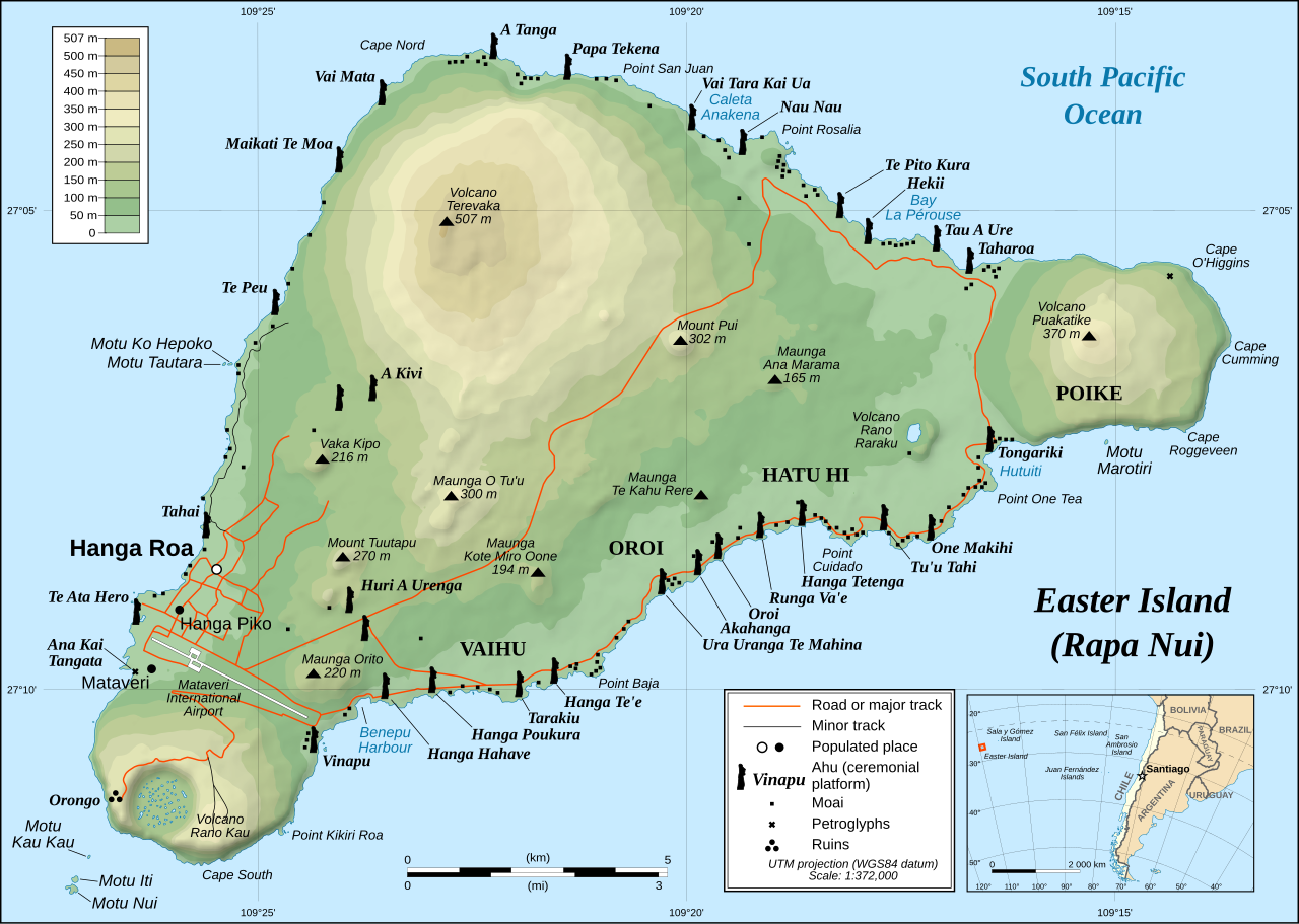
This image was selected as picture of the day on Wikimedia Commons for 1 December 2008. It was captioned as follows: English: Detailed topographic map in English of Easter Island. Other languages:
Afrikaans: Gedetaileerde topografie van Paaseiland Català: Mapa topogràfic detallat en anglès de l'Illa de Pasqua. Čeština: Detailní topografická mapa Velikonočního ostrova Eesti: Detailne inglisekeelne topograafiline kaart et:Lihavõttesaarest. English: Detailed topographic map in English of Easter Island. Esperanto: detala topografia mapo de la Paskinsulo (jen anglalingva, sed ankaŭ havebla en pluraj aliaj lingvoj) Français : Carte topographique détaillée en anglais de l'île de Pâques Italiano: Mappa topografica dell'Isola di Pasqua, Cile. Nederlands: Engelstalige gedetailleerde topografische kaart van Paaseiland Português: Mapa topográfico detalhado, em Inglês, da Ilha da Páscoa Română: Hartă topografică detaliată, în limba engleză, a insulei Paștelui. Svenska: Detaljerad topografisk karta på engelska över Påskön. Македонски: Детална топографска карта на Велигденскиот Остров на англиски. Русский: Топографическая карта Острова Пасхи 한국어: 이스터 섬의 지형도. 中文: 复活节岛地形图 中文(繁體): 復活節島地形圖 |
|

| تفصیل |
English: Detailed topographic map in English of Easter Island
Français : Carte topographique détaillée en anglais de l'île de Paques
Português: Mapa topográfico detalhado, em Inglês, da Ilha da Páscoa.
|
| تریخ | October 2007 - October 2008 for the new version (see the release note) |
| سروت |
Own work
|
| لکھاری | Eric Gaba (Sting), translated by Bamse |
| اجازت (فائل نوں دوبارہ ورتنا) |
Creative Commons: Share Alike – attribution required |
| دوجے ورژن |
[]
|


![[1]](http://www.waymarker.co.uk/ml/rapanui/map.jpg)
This W3C-unspecified vector image was created with Inkscape .

|
This SVG file contains embedded text that can be translated into your language, using any capable SVG editor, text editor or the SVG Translate tool. For more information see: About translating SVG files. |
لائسنس –
میں، اس کم دے کاپیرائٹ دا مالک، اس کم نوں اس لائسنس دے مطابق چھاپدا واں:
ایس فائل نوں کریٹو کامنز Attribution 2.5 جنرک لائسنس دتا گیا.
- تہانوں کھلھ اے:
- حصہ کرنا – کاپی، ونڈنا تے کم بھیجنا
- فیر رلانا – کم نوں فٹ کرنا
- تھلے دتیاں شرطاں نال:
- کس دے ناں – تسیں لازمی ایس کم دے بناں والے بارے دسو جنج اونے آکھیا اے یا جنج لسنس چ آکھیا گیا ہے۔
- اکو جہا شئیر کرو۔ – اگر تسیں بدلدے یا ایس کم تے بناندے تے بنن والے کم نوں اینج دے لسنس نال ای ونڈو گے۔
فائل دی تریخ
فائل نو اس ویلے دی حالت وچ ویکھن واسطے تاریخ/ویلے تے کلک کرو۔
| تریخ تے ویلہ | نکی مورت | پاسے | ورتن والا | تیپّݨی کرو | |
|---|---|---|---|---|---|
| موجودہ | ۰۳:۵۱, ۱۲ جنوری ۲۰۲۳ | | ۱,۷۵۰ × ۱,۲۴۵ (۸۷۸ کلوبائٹ) | Tseng,Lu-Yen | Reverted to version as of 12:43, 22 October 2008 (UTC) |
| ۱۲:۱۷, ۱۰ دسمبر ۲۰۱۱ |  | ۱,۷۵۰ × ۱,۲۴۵ (۱.۹۲ میگابائٹ) | Hel-hama | Text appearance improved using Inkscape. | |
| ۱۷:۴۳, ۲۲ اکتوبر ۲۰۰۸ |  | ۱,۷۵۰ × ۱,۲۴۵ (۸۷۸ کلوبائٹ) | Sting | Completely new version of the map ; new standard colors | |
| ۰۶:۰۶, ۳۰ اکتوبر ۲۰۰۷ |  | ۱,۷۵۰ × ۱,۲۴۵ (۵۳۶ کلوبائٹ) | Sting | Some additional info | |
| ۰۵:۳۷, ۱۹ اکتوبر ۲۰۰۷ |  | ۱,۷۵۰ × ۱,۲۴۵ (۵۳۴ کلوبائٹ) | Bamse | ||
| ۰۵:۱۴, ۱۹ اکتوبر ۲۰۰۷ |  | ۱,۷۵۰ × ۱,۲۴۵ (۵۳۴ کلوبائٹ) | Bamse | {{Information |Description= |Source=self-made |Date= |Author= Bamse }} == Summary == {{Information| |Description=Detailed topographic map in English of Easter island |Source=Own work, translation of Image:Easter Island map-fr.svg<b |
فائل دی ورتوں
تھلے دتے گئے 1 صفحے اس فائل نال جُڑدے نیں
فائل ویاپک ورتوں
ایہہ دوجے وکیاں ایس فائل نوں ورتدے نیں –
- af.wikipedia.org تے ورتوں
- ami.wikipedia.org تے ورتوں
- ar.wikipedia.org تے ورتوں
- az.wikipedia.org تے ورتوں
- bcl.wikipedia.org تے ورتوں
- bn.wikipedia.org تے ورتوں
- ca.wikipedia.org تے ورتوں
- ckb.wikipedia.org تے ورتوں
- da.wikipedia.org تے ورتوں
- de.wikipedia.org تے ورتوں
- el.wikipedia.org تے ورتوں
- en.wikipedia.org تے ورتوں
- Cartography
- Easter Island
- Hanga Roa
- Mu (mythical lost continent)
- Moai
- Motu Nui
- Map coloring
- Rapa Nui National Park
- Hanau epe
- Orongo
- Ahu Tongariki
- Poike
- Rano Kau
- Terevaka
- Ahu Akivi
- List of active separatist movements in Oceania
- User:ISaveNewspapers/sandbox
- Isla de Pascua (commune)
- Portal:Geodesy
- User:Iamojo/testcase/EasterIsland
- en.wikiversity.org تے ورتوں
- en.wikivoyage.org تے ورتوں
- es.wikipedia.org تے ورتوں
- et.wikipedia.org تے ورتوں
- fa.wikipedia.org تے ورتوں
- frr.wikipedia.org تے ورتوں
- fr.wikipedia.org تے ورتوں
- gl.wikipedia.org تے ورتوں
ایس فائل دا ویکھو ہور جگت ورتن .