فائل:Cy-map.png

اس توں وڈی مورت موجود نہیں۔
Cy-map.png (۶۲۹ × ۳۱۹ پکسلز, فائل حجم: ۱۲ کلوبائٹ, MIME type: image/png)

|
This map image could be re-created using vector graphics as an SVG file. This has several advantages; see Commons:Media for cleanup for more information. If an SVG form of this image is available, please upload it and afterwards replace this template with
{{vector version available|new image name}}.
It is recommended to name the SVG file “Cy-map.svg”—then the template Vector version available (or Vva) does not need the new image name parameter. |
خلاصہ
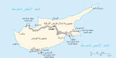
| تفصیل | Cyprus map from CIA World Factbook, converted from original GIF format |
| تریخ | |
| سروت | CIA World Factbook: Cyprus. Archived from the original on ۳ جون ۲۰۰۳. |
| لکھاری | United States Central Intelligence Agency |
| دوجے ورژن |
|
لائسنس –
This image is in the public domain because it contains materials that originally came from the United States Central Intelligence Agency's World Factbook.
|
 |
Derivative works
-
 Cy-map-ger.png
Deutsch

-
 Arabic

فائل دی تریخ
فائل نو اس ویلے دی حالت وچ ویکھن واسطے تاریخ/ویلے تے کلک کرو۔
| تریخ تے ویلہ | نکی مورت | پاسے | ورتن والا | تیپّݨی کرو | |
|---|---|---|---|---|---|
| موجودہ | ۰۱:۳۰, ۲۸ نومبر ۲۰۰۴ | | ۶۲۹ × ۳۱۹ (۱۲ کلوبائٹ) | Kneiphof | CIA Cyprus map |
فائل دی ورتوں
تھلے دتے گئے 1 صفحے اس فائل نال جُڑدے نیں
فائل ویاپک ورتوں
ایہہ دوجے وکیاں ایس فائل نوں ورتدے نیں –
- azb.wikipedia.org تے ورتوں
- be.wikipedia.org تے ورتوں
- ca.wikipedia.org تے ورتوں
- ckb.wikipedia.org تے ورتوں
- cs.wikinews.org تے ورتوں
- de.wikipedia.org تے ورتوں
- dsb.wikipedia.org تے ورتوں
- en.wikipedia.org تے ورتوں
- Cyprus
- Turkish invasion of Cyprus
- Greek junta
- Portal:Cyprus
- Greek New Zealanders
- United Nations Security Council Resolution 370
- United Nations Security Council Resolution 383
- United Nations Security Council Resolution 391
- United Nations Security Council Resolution 401
- United Nations Security Council Resolution 410
- United Nations Security Council Resolution 422
- United Nations Security Council Resolution 430
- United Nations Security Council Resolution 440
- United Nations Security Council Resolution 443
- Category:Populated places in Cyprus
- Talk:Grand Lodge of Cyprus
- en.wikivoyage.org تے ورتوں
- eo.wikipedia.org تے ورتوں
- fa.wikipedia.org تے ورتوں
- fr.wikipedia.org تے ورتوں
- Résolution 370 du Conseil de sécurité des Nations unies
- Résolution 383 du Conseil de sécurité des Nations unies
- Résolution 391 du Conseil de sécurité des Nations unies
- Résolution 401 du Conseil de sécurité des Nations unies
- Résolution 410 du Conseil de sécurité des Nations unies
- Résolution 422 du Conseil de sécurité des Nations unies
ایس فائل دا ویکھو ہور جگت ورتن .