فائل:CountriesRecognizingKosovo.svg

Size of this PNG preview of this SVG file: ۸۰۰ × ۳۴۹ پکسلز. دوجے ریزولوشنز: ۳۲۰ × ۱۳۹ پکسلز | ۶۴۰ × ۲۷۹ پکسلز | ۱,۰۲۴ × ۴۴۶ پکسلز | ۱,۲۸۰ × ۵۵۸ پکسلز | ۲,۵۶۰ × ۱,۱۱۵ پکسلز | ۲,۷۵۴ × ۱,۲۰۰ پکسلز ۔
اصل فائل (ایس وی جی فائل، پکسل:۲,۷۵۴ × ۱,۲۰۰، فائل سائز: ۱.۱۱ میگابائٹ)

خلاصہ
| تفصیل |
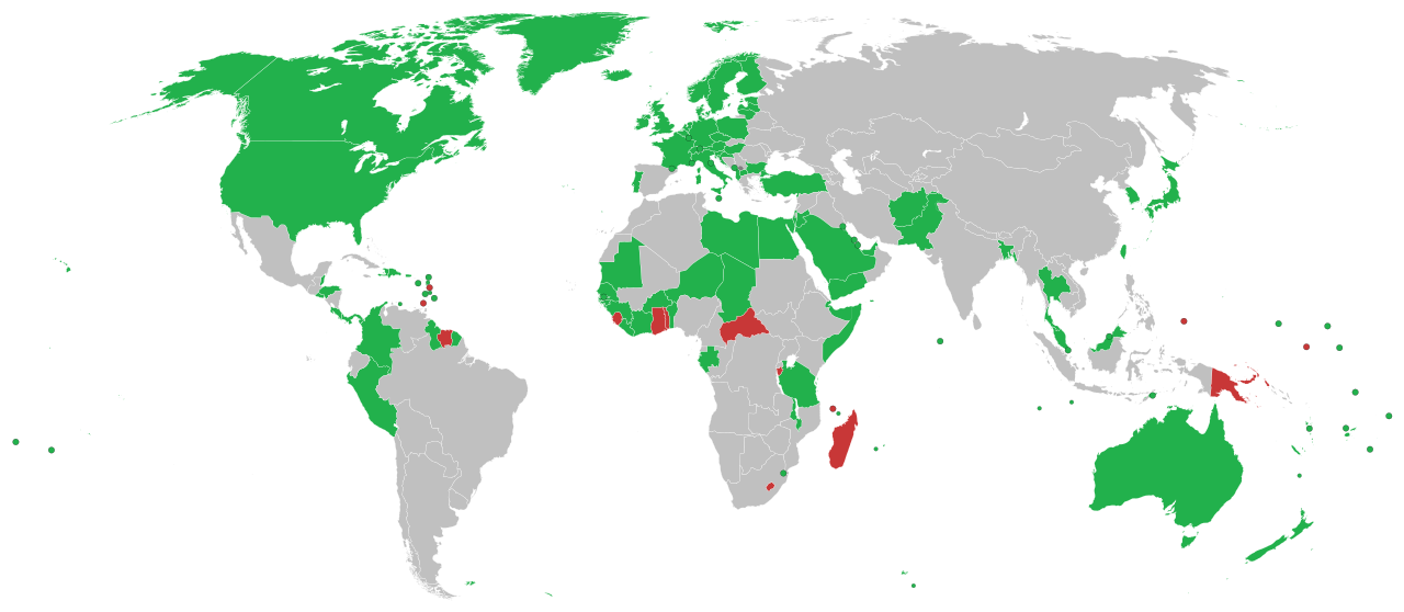
English: This is a map of countries recognizing independence of Kosovo
Recognise Kosovo as independent The region of Kosovo Withdrawn recognition Hrvatski: Ovo je karta koja prikazuje države koje su priznale neovisnost Kosova
Priznaju neovisnost Kosova Español: Mapa de los países que reconocen la independencia de Kosovo
Deutsch: Länder in Grün erkennen den Kosovo als unabhängigen Staat an. Länder in rot haben die Anerkennung zurückgezogen.
Italiano: Mappa dei paesi che hanno riconosciuto l'indipendenza del Kosovo.
Português: Mapa dos países que reconhecem a independência do Kosovo.
Română: Aceasta este o hartă care arată recunoașterea independenței Republicii Kosovo pe plan internațional
Svenska: En karta över länder som formellt erkänner Kosovos självständighetsförklaring
Formellt erkänner Kosovos självständighetsförklaring Återkallat erkännande Türkçe: Kosova'nın bağımsızlığını tanıyan ülkelerin haritası
Українська: Карта країн, що визнають незалежність Косова.
العربية: هذه خريطة الدول التي تعترف بكوسوفو كدولة مستقلة الدول التي تعترف بكوسوفو كدولة مستقلة الدول التي سحبت اعترافها بكوسوفو كدولة مستقلة الدول التي لا تعترف بكوسوفو كدولة مستقلة |
| تریخ |
۱۷ ستمبر ۲۰۰۸ (original upload date) |
| سروت |
English Wikipedia http://en.wikipedia.org/wiki/Image:CountriesRecognizingKosovo.png (Original text: March-May 2008 and ongoing) |
| لکھاری | Alethiareg, ArturM, Balfabio, Avala, Mareklug, Cradel, Gugganij, Husond, en, Zscout370, en, Chech Explorer, Camptown, Hoshie, Nightstallion, Ijanderson977 / The original uploader was Alethiareg at English وکیپیڈیا. |
| دوجے ورژن | CountriesRecognizingKosovo.png |
| SVG genesis |
لائسنس –
| اس کم نوں لوکاں لئی ایدے لکھاریAlethiareg at English وکیپیڈیا نے دے دتا اے، اے سارے جگ واسطے لاگو اے۔ کج ملکاں چ قانونی طور تے اے ممکن نئیں اے؛ اگر انج ای اے ے: Alethiareg ہر کسے نوں اس کم نوں کسے وی مقصد واسطے ورتن دا بغیر کسے شرط دے حق دیندا واں، اگر اوہ قانون دے خلاف نا ہوۓ۔ |
پہلا اپلوڈ دا ریکارڈ
Transferred from en.wikipedia to Commons by EmilJ using CommonsHelper.
The original description page was here. All following user names refer to en.wikipedia.
- 14:22, 17 September 2008 940×415 (1.45 MB) EmilJ add Taiwan, omit circles for dependent territories
- 11:46, 16 September 2008 940×415 (1.45 MB) EmilJ Samoa recognized
- 14:20, 15 September 2008 940×415 (1.45 MB) EmilJ use CSS, add missing countries and territories
- 09:39, 15 September 2008 940×415 (1.49 MB) Alethiareg == Summary == {{Information |Description=This is a map of countries recognizing independence of Kosovo. |Author =User:Alethiareg, User:ArturM, User:Balfabio, [[User:Av
فائل دی تریخ
فائل نو اس ویلے دی حالت وچ ویکھن واسطے تاریخ/ویلے تے کلک کرو۔
| تریخ تے ویلہ | نکی مورت | پاسے | ورتن والا | تیپّݨی کرو | |
|---|---|---|---|---|---|
| موجودہ | ۰۴:۵۴, ۲ جنوری ۲۰۲۲ | | ۲,۷۵۴ × ۱,۲۰۰ (۱.۱۱ میگابائٹ) | Kwamikagami | color integral constituents (Puerto Rico, New Caledonia, etc.) |
| ۰۲:۲۳, ۲۷ اپریل ۲۰۲۱ |  | ۲,۷۵۴ × ۱,۲۰۰ (۱.۰۵ میگابائٹ) | NordNordWest | Reverted to version as of 06:02, 25 February 2021 (UTC) | |
| ۲۱:۵۸, ۲۵ اپریل ۲۰۲۱ |  | ۵۱۲ × ۲۲۳ (۸۰۵ کلوبائٹ) | ויקי4800 | תיקון גבולות מדינת ישראל | |
| ۱۱:۰۲, ۲۵ فروری ۲۰۲۱ |  | ۲,۷۵۴ × ۱,۲۰۰ (۱.۰۵ میگابائٹ) | Liggliluff | Replacing file with BlankMap-World.svg for a better look, countries coloured by the style-code, should be correct to the last map, the image is cropped and ocean hidden, micro-nations have circles, and hovering shows popups | |
| ۰۴:۵۵, ۹ فروری ۲۰۲۱ |  | ۱,۶۵۰ × ۷۵۰ (۹۱۸ کلوبائٹ) | Arianasmithy74 | Reverted to version as of 21:31, 29 December 2020 (UTC) | |
| ۲۲:۳۲, ۷ فروری ۲۰۲۱ |  | ۱,۶۵۰ × ۷۵۰ (۹۱۸ کلوبائٹ) | Arianasmithy74 | Comoros now sent a letter to Kosovo saying that they still recognise Kosovo | |
| ۰۲:۳۱, ۳۰ دسمبر ۲۰۲۰ |  | ۱,۶۵۰ × ۷۵۰ (۹۱۸ کلوبائٹ) | Arianasmithy74 | Brunei is green again. | |
| ۰۲:۱۸, ۳۰ دسمبر ۲۰۲۰ |  | ۱,۶۵۰ × ۷۵۰ (۹۱۸ کلوبائٹ) | Arianasmithy74 | Nauru is now red as it withdrew recognition. | |
| ۲۰:۴۱, ۲۷ دسمبر ۲۰۲۰ |  | ۱,۶۵۰ × ۷۵۰ (۹۱۸ کلوبائٹ) | Arianasmithy74 | Brunei is now green Also, 'nu' is Niue so it is not supposed to be red | |
| ۱۶:۰۵, ۱۱ دسمبر ۲۰۲۰ |  | ۱,۶۵۰ × ۷۵۰ (۹۱۸ کلوبائٹ) | Kwamikagami | withdrawn recognition |
فائل دی ورتوں
تھلے دتے گئے 1 صفحے اس فائل نال جُڑدے نیں
فائل ویاپک ورتوں
ایہہ دوجے وکیاں ایس فائل نوں ورتدے نیں –
- af.wikipedia.org تے ورتوں
- ar.wikipedia.org تے ورتوں
- arz.wikipedia.org تے ورتوں
- ast.wikipedia.org تے ورتوں
- bg.wikipedia.org تے ورتوں
- bn.wikipedia.org تے ورتوں
- ca.wikipedia.org تے ورتوں
- cs.wikipedia.org تے ورتوں
- de.wikipedia.org تے ورتوں
- Benutzer:Generator
- Geschichte des Kosovo
- Liste der Gebiete mit begrenzter Anerkennung als Staat
- Kosovo
- Portal:Kosovo/Artikel des Monats
- Diskussion:Kosovo/Archiv/005
- Internationale Anerkennung des Kosovo
- Diskussion:Kosovo/Archiv/006
- Diskussion:Internationale Anerkennung des Kosovo/Archiv
- Wikipedia:Kartenwerkstatt/Archiv/2018-03
- el.wikipedia.org تے ورتوں
- en.wikipedia.org تے ورتوں
- es.wikipedia.org تے ورتوں
- fa.wikipedia.org تے ورتوں
- fi.wikipedia.org تے ورتوں
- fr.wikipedia.org تے ورتوں
- gl.wikipedia.org تے ورتوں
- hr.wikipedia.org تے ورتوں
- hu.wikipedia.org تے ورتوں
- hy.wikipedia.org تے ورتوں
- id.wikipedia.org تے ورتوں
- incubator.wikimedia.org تے ورتوں
- it.wikipedia.org تے ورتوں
ایس فائل دا ویکھو ہور جگت ورتن .