فائل:China-Historic macro areas.svg

اصل فائل (ایس وی جی فائل، پکسل:۱,۴۳۸ × ۱,۰۴۷، فائل سائز: ۳.۶۱ میگابائٹ)
خلاصہ
| تفصیل |
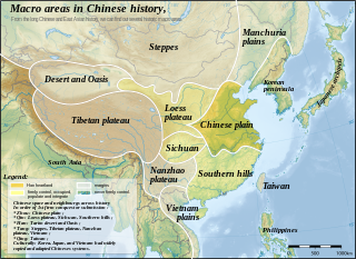
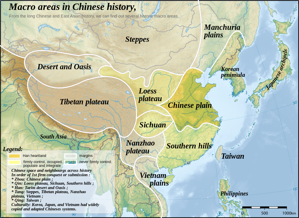
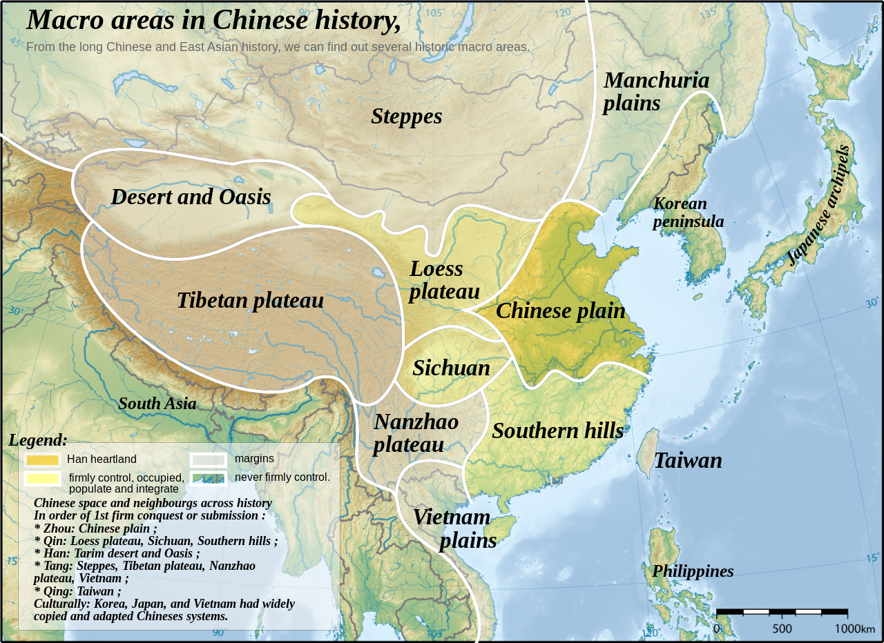
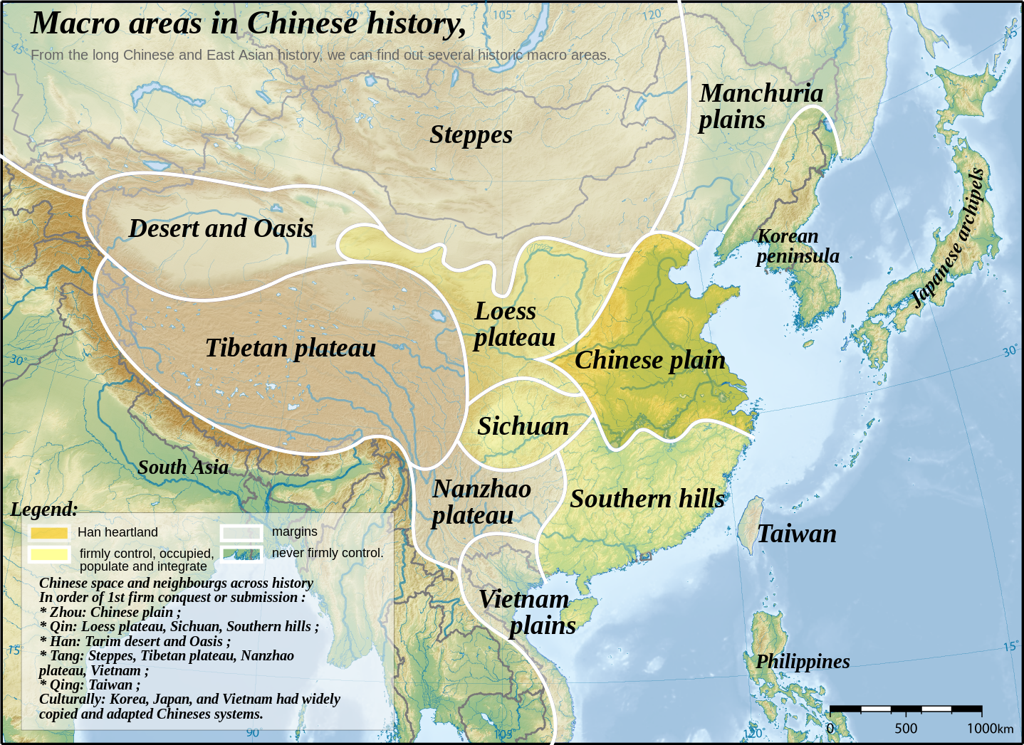
English: Topographic map of East Asia, with historical areas and macro-regions of China depicted.
中文(简体):东亚地形图。
中文(繁體):東亞地形圖。
日本語: 東アジアの地形図。
한국어: 동아시아의 지형도.
Tiếng Việt: Bản đồ địa hình khu vực Đông Á.
Català: Mapa topogràfic de l'Àsia Oriental, amb les macroàrees històriques de la Xina descrites. |
||
| تریخ | |||
| سروت | East Asia topographic map.png by Ksiom | ||
| لکھاری | Yug | ||
| دوجے ورژن |
File:China-Historic macro areas.svg has 2 translations.
|
||
| SVG genesis |
|


see also: http://uk.wikipedia.org/wiki/%D0%A4%D0%B0%D0%B9%D0%BB:China-Historic_macro_areas-uk.png
The map has been created with the Generic Mapping Tools: https://www.generic-mapping-tools.org/ using one or more of these public-domain datasets for the relief:
|

|
کاپی کرن، ونڈن تے بدلن دی ایس ڈوکومنٹ لئی اجازت دتی جاندی اے ایہناں GNU Free Documentation License, Version 1.2 شرطاں نال یا مگروں کسے وی چھپے ورین Free Software Foundation توں بنا کسے انویرینٹ سیکشن دے، ناں فرنٹ کور لکھت تے ناں بیک کور لکھت دے۔ لسنس دی اک کاپی سیکشن وچ ہیگی اے جہدا ناں اے GNU Free Documentation License۔ |
| ایس فائل نوں کریٹو کامنز Attribution 2.5 پولینڈ لائسنس دتا گیا. | ||
| ||
| اس لائسنس دا ٹیگ GFDL دے مطابق اس فائل چ پایا گیا اے licensing update۔ |

|
This SVG file contains embedded text that can be translated into your language, using any capable SVG editor, text editor or the SVG Translate tool. For more information see: About translating SVG files. |
This file is translated using SVG <switch> elements. All translations are stored in the same file! Learn more.
For most Wikipedia projects, you can embed the file normally (without a To translate the text into your language, you can use the SVG Translate tool. Alternatively, you can download the file to your computer, add your translations using whatever software you're familiar with, and re-upload it with the same name. You will find help in Graphics Lab if you're not sure how to do this. |
پہلا اپلوڈ دا ریکارڈ
This image is a derivative work of the following images:
- East Asia topographic map.png licensed with GFDL-GMT
- 2008-08-17T05:11:19Z Ksiom 2876x2094 (9245630 Bytes) {{Information |Description={{en|1=Topographic map of East Asia.}} {{ko|1=동아시아의 지형도.}} |Source=Own work by uploader |Author=[[User:Ksiom|Ksiom]] |Date=2008-08-17 |Permission={{GFDL-GMT}} |other_versions= }} [
Uploaded with derivativeFX
فائل دی تریخ
فائل نو اس ویلے دی حالت وچ ویکھن واسطے تاریخ/ویلے تے کلک کرو۔
| تریخ تے ویلہ | نکی مورت | پاسے | ورتن والا | تیپّݨی کرو | |
|---|---|---|---|---|---|
| موجودہ | ۱۸:۴۸, ۱۸ ستمبر ۲۰۲۳ | | ۱,۴۳۸ × ۱,۰۴۷ (۳.۶۱ میگابائٹ) | JoanSMF | File uploaded using svgtranslate tool (https://svgtranslate.toolforge.org/). Added translation for ca. |
| ۱۷:۵۰, ۱۸ ستمبر ۲۰۲۳ |  | ۱,۴۳۸ × ۱,۰۴۷ (۳.۶ میگابائٹ) | JoanSMF | File uploaded using svgtranslate tool (https://svgtranslate.toolforge.org/). Added translation for ca. | |
| ۲۱:۱۹, ۱۳ دسمبر ۲۰۰۸ |  | ۱,۴۳۸ × ۱,۰۴۷ (۳.۵۹ میگابائٹ) | Yug | ||
| ۲۱:۰۱, ۱۳ دسمبر ۲۰۰۸ |  | ۱,۴۳۸ × ۱,۰۴۷ (۲۶۷ کلوبائٹ) | Yug | ||
| ۱۶:۳۸, ۱۳ دسمبر ۲۰۰۸ |  | ۱,۴۳۸ × ۱,۰۴۷ (۳.۵۸ میگابائٹ) | Yug | Reverted to version as of 06:33, 12 December 2008 | |
| ۱۶:۲۵, ۱۳ دسمبر ۲۰۰۸ |  | ۱,۴۳۸ × ۱,۰۴۷ (۲۴۹ کلوبائٹ) | Yug | Smaller, to fix wikimedia svg to png convertor's limit. | |
| ۱۱:۳۳, ۱۲ دسمبر ۲۰۰۸ |  | ۱,۴۳۸ × ۱,۰۴۷ (۳.۵۸ میگابائٹ) | Yug | Reverted to version as of 23:19, 2 December 2008 | |
| ۱۱:۳۰, ۱۲ دسمبر ۲۰۰۸ |  | ۲,۸۷۶ × ۲,۰۹۴ (۱۲.۱۵ میگابائٹ) | Yug | ||
| ۰۴:۱۹, ۳ دسمبر ۲۰۰۸ |  | ۱,۴۳۸ × ۱,۰۴۷ (۳.۵۸ میگابائٹ) | Yug | SVG with smaller Bitmap image embeded inside. To ease usage (wiki bitmap generator script need small SVG to work fine). | |
| ۰۴:۳۱, ۳۰ نومبر ۲۰۰۸ |  | ۲,۸۷۶ × ۲,۰۹۴ (۱۲.۱۵ میگابائٹ) | Yug | {{Information |Description={{en|1=Topographic map of East Asia.}} {{ko|1=동아시아의 지형도.}} |Source=*Image:East_Asia_topographic_map.png |Date=2008-11-29 23:09 (UTC) |Author=*derivative work: ~~~ *Image:East_Asia_topographic_map.png: |
فائل دی ورتوں
تھلے دتے گئے 1 صفحے اس فائل نال جُڑدے نیں
فائل ویاپک ورتوں
ایہہ دوجے وکیاں ایس فائل نوں ورتدے نیں –
- af.wikipedia.org تے ورتوں
- bg.wikipedia.org تے ورتوں
- ca.wikipedia.org تے ورتوں
- da.wikipedia.org تے ورتوں
- en.wikipedia.org تے ورتوں
- fa.wikipedia.org تے ورتوں
- fr.wikipedia.org تے ورتوں
- hy.wikipedia.org تے ورتوں
- it.wikipedia.org تے ورتوں
- ja.wikipedia.org تے ورتوں
- nl.wikipedia.org تے ورتوں
- sl.wikipedia.org تے ورتوں