فائل:CarlSaxET1877.jpg
اصل فائل (۳,۱۰۰ × ۲,۹۶۸ پکسلز, فائل حجم: ۷.۵۷ میگابائٹ, MIME type: image/jpeg)
خلاصہ
| تفصیل |
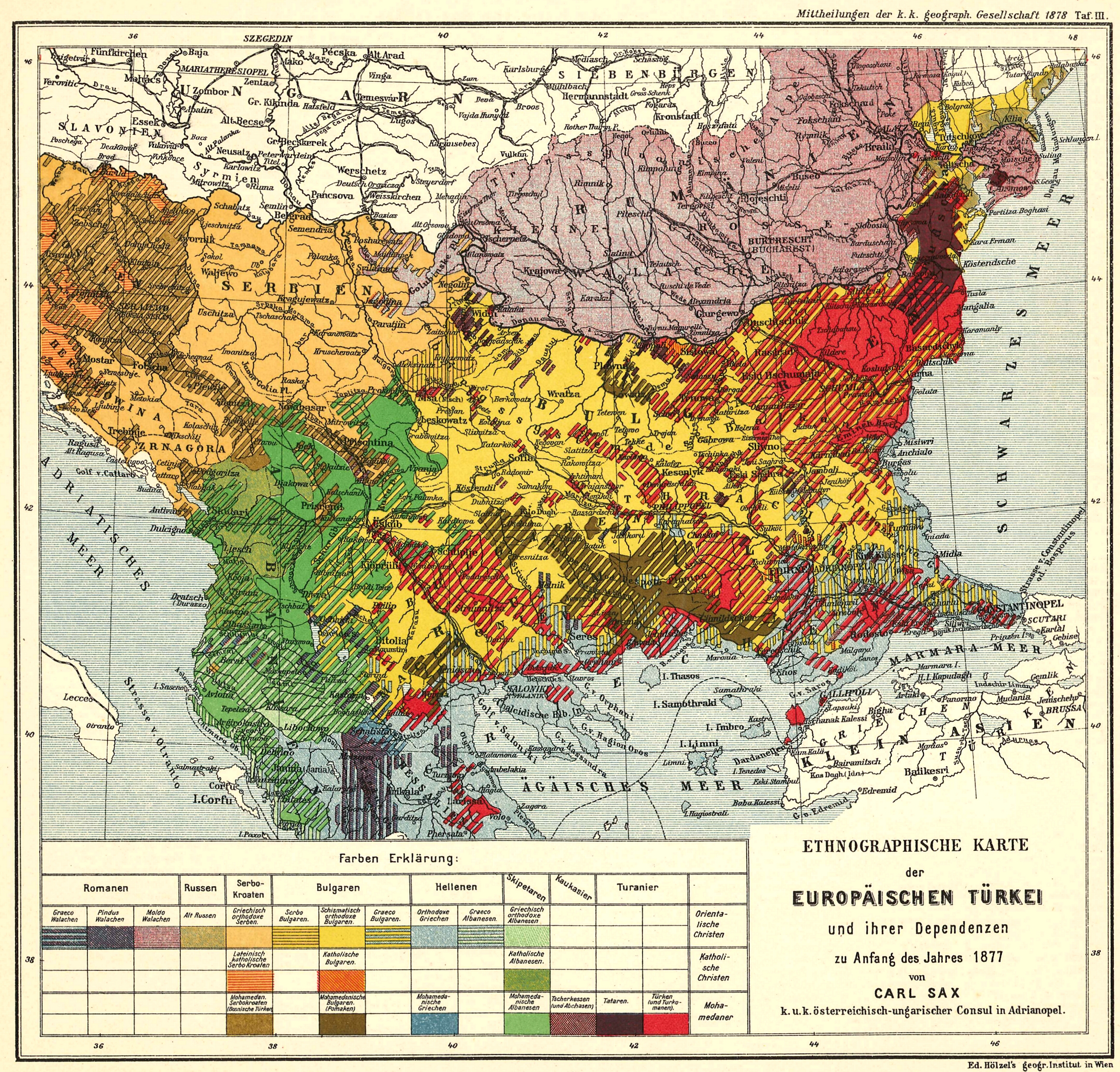
English: Ethnological Map of European Turkey and her Dependencies at the Time of the Beginning of the War of 1877, by Karl Sax, I. and R. Austro-Hungarian Consul at Adrianople. Published by the Imperial and Royal Geographical Society, Vienna 1878.
Български: Етнографска карта на Европейска Турция, автор: Карл Закс, 1877-1878 |
| تریخ | ۱۸۷۷ - ۱۸۷۸ |
| سروت | The Bulgarians in their historical, ethnographical and political frontiers, 1917 |
| لکھاری | Carl Sax |
لائسنس –
|
This work is in the public domain in its country of origin and other countries and areas where the copyright term is the author's life plus 70 years or fewer.
| |
| ایہ فائل دے بارے چ دس اے جے اے کاپی حف دیاں روکاں توں کھلی اے تے نالدے رلدے حقاں توں وی۔ | |
فائل دی تریخ
فائل نو اس ویلے دی حالت وچ ویکھن واسطے تاریخ/ویلے تے کلک کرو۔
| تریخ تے ویلہ | نکی مورت | پاسے | ورتن والا | تیپّݨی کرو | |
|---|---|---|---|---|---|
| موجودہ | ۱۵:۰۴, ۲۸ مئی ۲۰۰۸ | | ۳,۱۰۰ × ۲,۹۶۸ (۷.۵۷ میگابائٹ) | Alexandar.R.~commonswiki | {{Information |Description={{en|1=Ethnological Map of European Turkey and her Dependencies at the Time of the Beginning of the War of 1877, by Karl Sax, I. and R. Austro-Hungarian Consul at Adrianople. Publisched by the Imperial and Royal Geographical Soc |
فائل دی ورتوں
تھلے دتے گئے 1 صفحے اس فائل نال جُڑدے نیں
فائل ویاپک ورتوں
ایہہ دوجے وکیاں ایس فائل نوں ورتدے نیں –
- ba.wikipedia.org تے ورتوں
- bg.wikipedia.org تے ورتوں
- cv.wikipedia.org تے ورتوں
- de.wikipedia.org تے ورتوں
- en.wikipedia.org تے ورتوں
- Demographic history of Macedonia
- Talk:Albanians in North Macedonia
- History of the Bulgarian language
- Bulgarian Turks
- Albanians in Serbia
- Wikipedia:Articles for deletion/Log/2010 April 29
- Wikipedia:Articles for deletion/Genocide of Ottoman Turks and Muslims
- Talk:Albanians/Archive 3
- User:Falcaorib
- Circassians in Romania
- et.wikipedia.org تے ورتوں
- hu.wikipedia.org تے ورتوں
- it.wikipedia.org تے ورتوں
- ro.wikipedia.org تے ورتوں
- ru.wikipedia.org تے ورتوں
- sq.wikipedia.org تے ورتوں
- sr.wikipedia.org تے ورتوں
- tr.wikipedia.org تے ورتوں
- ur.wikipedia.org تے ورتوں