فائل:Cambodia-Kampong Cham.png

ایس وکھالے دا ناپ: ۶۴۴ × ۵۹۹ پکسلز۔ دوجے ریزولوشنز: ۲۵۸ × ۲۴۰ پکسلز | ۵۱۶ × ۴۸۰ پکسلز | ۶۶۴ × ۶۱۸ پکسلز ۔
اصل فائل (۶۶۴ × ۶۱۸ پکسلز, فائل حجم: ۱۴۹ کلوبائٹ, MIME type: image/png)

|
This locator map image could be re-created using vector graphics as an SVG file. This has several advantages; see Commons:Media for cleanup for more information. If an SVG form of this image is available, please upload it and afterwards replace this template with
{{vector version available|new image name}}.
It is recommended to name the SVG file “Cambodia-Kampong Cham.svg”—then the template Vector version available (or Vva) does not need the new image name parameter. |
خلاصہ
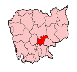
Map of Cambodia showing Kampong Cham province.
Made by User:Golbez based on a map by Morwen on en.wikipedia.org.
لائسنس –

|
کاپی کرن، ونڈن تے بدلن دی ایس ڈوکومنٹ لئی اجازت دتی جاندی اے ایہناں GNU Free Documentation License, Version 1.2 شرطاں نال یا مگروں کسے وی چھپے ورین Free Software Foundation توں بنا کسے انویرینٹ سیکشن دے، ناں فرنٹ کور لکھت تے ناں بیک کور لکھت دے۔ لسنس دی اک کاپی سیکشن وچ ہیگی اے جہدا ناں اے GNU Free Documentation License۔ |
| ایس فائل نوں کریٹو کامنز Attribution 2.5 پولینڈ لائسنس دتا گیا. | ||
| ||
| اس لائسنس دا ٹیگ GFDL دے مطابق اس فائل چ پایا گیا اے licensing update۔ |
فائل دی تریخ
فائل نو اس ویلے دی حالت وچ ویکھن واسطے تاریخ/ویلے تے کلک کرو۔
| تریخ تے ویلہ | نکی مورت | پاسے | ورتن والا | تیپّݨی کرو | |
|---|---|---|---|---|---|
| موجودہ | ۱۹:۳۲, ۱۰ دسمبر ۲۰۱۴ | | ۶۶۴ × ۶۱۸ (۱۴۹ کلوبائٹ) | Nisetpdajsankha | the province was separated into Kampong Cham and Tboung Khmom |
| ۱۳:۵۴, ۲۰ دسمبر ۲۰۰۵ |  | ۲۰۰ × ۱۶۱ (۶ کلوبائٹ) | Golbez | Map of Cambodia showing Kampong Cham province. Made by User:Golbez based on a map by Morwen on en.wikipedia.org. Category:Maps of Cambodia |
فائل دی ورتوں
تھلے دتے گئے 1 صفحے اس فائل نال جُڑدے نیں
فائل ویاپک ورتوں
ایہہ دوجے وکیاں ایس فائل نوں ورتدے نیں –
- ca.wikipedia.org تے ورتوں
- km.wikipedia.org تے ورتوں
- new.wikipedia.org تے ورتوں
- pam.wikipedia.org تے ورتوں
- vi.wikipedia.org تے ورتوں
- war.wikipedia.org تے ورتوں