فائل:Brit IndianEmpireReligions3.jpg

ایس وکھالے دا ناپ: ۷۴۱ × ۵۹۹ پکسلز۔ دوجے ریزولوشنز: ۲۹۷ × ۲۴۰ پکسلز | ۵۹۳ × ۴۸۰ پکسلز | ۹۴۹ × ۷۶۸ پکسلز | ۱,۲۶۶ × ۱,۰۲۴ پکسلز | ۱,۵۳۴ × ۱,۲۴۱ پکسلز ۔
اصل فائل (۱,۵۳۴ × ۱,۲۴۱ پکسلز, فائل حجم: ۲.۳۳ میگابائٹ, MIME type: image/jpeg)
خلاصہ
| تفصیل |
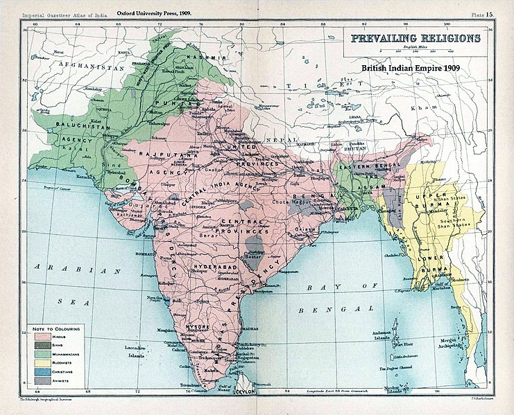
English: Map "Prevailing Religions of the British Indian Empire, 1909" Key:
|
| تریخ | |
| سروت | The Imperial Gazetteer of India, Oxford University Press, 1909. Scanned from personal copy and annotated by me (Fowler&fowler«Talk» 04:16, 19 March 2007 (UTC)) |
| لکھاری |
English: John George Bartholomew |
| دوجے ورژن |
.jpg)


|
This old map image could be re-created using vector graphics as an SVG file. This has several advantages; see Commons:Media for cleanup for more information. If an SVG form of this image is available, please upload it and afterwards replace this template with
{{vector version available|new image name}}.
It is recommended to name the SVG file “Brit IndianEmpireReligions3.svg”—then the template Vector version available (or Vva) does not need the new image name parameter. |


لائسنس –
|
The author died in 1920, so this work is in the public domain in its country of origin and other countries and areas where the copyright term is the author's life plus 100 years or fewer. This work is in the public domain in the United States because it was published (or registered with the U.S. Copyright Office) before January 1, 1929. | |
| ایہ فائل دے بارے چ دس اے جے اے کاپی حف دیاں روکاں توں کھلی اے تے نالدے رلدے حقاں توں وی۔ | |
پہلا اپلوڈ دا ریکارڈ
The original description page was here. All following user names refer to en.wikipedia.
- 2007-03-19 04:16 Fowler&fowler 1650×1275×8 (338398 bytes) Map "Prevailing Religions of the British Indian Empire, 1909" from the Imperial Gazetteer of India, Oxford University Press, 1909. Scanned from personal copy and annotated by me (~~~~) {{PD-old-75}}
| Annotations | This image is annotated: View the annotations at Commons |
فائل دی تریخ
فائل نو اس ویلے دی حالت وچ ویکھن واسطے تاریخ/ویلے تے کلک کرو۔
| تریخ تے ویلہ | نکی مورت | پاسے | ورتن والا | تیپّݨی کرو | |
|---|---|---|---|---|---|
| موجودہ | ۰۷:۳۹, ۱۸ جنوری ۲۰۱۹ | | ۱,۵۳۴ × ۱,۲۴۱ (۲.۳۳ میگابائٹ) | Frank Klemm | Cropped, white balanced |
| ۱۸:۲۷, ۲۹ دسمبر ۲۰۱۱ |  | ۱,۵۰۴ × ۱,۲۳۲ (۲.۰۶ میگابائٹ) | Maproom | Made colours less washed-out | |
| ۰۶:۲۰, ۱۱ فروری ۲۰۰۹ |  | ۱,۵۰۴ × ۱,۲۳۲ (۳۱۱ کلوبائٹ) | AnonMoos | losslessly cropping margins | |
| ۰۸:۰۶, ۲۱ ستمبر ۲۰۰۷ |  | ۱,۶۵۰ × ۱,۲۷۵ (۳۳۰ کلوبائٹ) | Shooke | {{Information |Description=Map "Prevailing Religions of the British Indian Empire, 1909" from the Imperial Gazetteer of India, Oxford University Press, 1909. Scanned from personal copy and annotated by me ([[:en:User:Fowler&fowler|<font color="#B8860B">F |
فائل دی ورتوں
تھلے دتے گئے 4 صفحے اس فائل نال جُڑدے نیں
فائل ویاپک ورتوں
ایہہ دوجے وکیاں ایس فائل نوں ورتدے نیں –
- af.wikipedia.org تے ورتوں
- ar.wikipedia.org تے ورتوں
- ast.wikipedia.org تے ورتوں
- az.wikipedia.org تے ورتوں
- ba.wikipedia.org تے ورتوں
- bg.wikipedia.org تے ورتوں
- bn.wikipedia.org تے ورتوں
- bn.wikiquote.org تے ورتوں
- ca.wikipedia.org تے ورتوں
- ckb.wikipedia.org تے ورتوں
- cs.wikipedia.org تے ورتوں
- de.wikipedia.org تے ورتوں
- diq.wikipedia.org تے ورتوں
- en.wikipedia.org تے ورتوں
- History of India
- Kashmir
- Partition of India
- Gazetteer
- History of Hinduism
- Dominion of India
- British Raj
- User:Fowler&fowler
- Talk:History of Pakistan/History of the Pakistan region
- User:Fowler&fowler/Short History Indian Independence Movement
- User:Fowler&fowler/History of Pakistan
- History of the British Raj
- History of East Pakistan
- Talk:Jammu and Kashmir (state)/Archive 1
- User talk:RegentsPark/Archive 4
- User:Fowler&fowler/History of the Pakistan region
- Talk:British Raj/Archive 8
- User:Falcaorib
- User:Կիմա34/sandbox
- es.wikipedia.org تے ورتوں
- eu.wikipedia.org تے ورتوں
- fa.wikipedia.org تے ورتوں
- fr.wikipedia.org تے ورتوں
ایس فائل دا ویکھو ہور جگت ورتن .