فائل:Austria-Hungary map de.svg

Size of this PNG preview of this SVG file: ۷۷۶ × ۶۰۰ پکسلز. دوجے ریزولوشنز: ۳۱۱ × ۲۴۰ پکسلز | ۶۲۱ × ۴۸۰ پکسلز | ۹۹۴ × ۷۶۸ پکسلز | ۱,۲۸۰ × ۹۸۹ پکسلز | ۲,۵۶۰ × ۱,۹۷۸ پکسلز | ۷۸۳ × ۶۰۵ پکسلز ۔
اصل فائل (ایس وی جی فائل، پکسل:۷۸۳ × ۶۰۵، فائل سائز: ۵۷۲ کلوبائٹ)
خلاصہ
| تفصیل |
Deutsch: Österreich-Ungarn 1910:
Magyar: Ausztria–Magyarország:
Latina: Austria-Hungaria:
Polski: Austro–Węgry:
English: Austria–Hungary:
Čeština: Rakousko-Uhersko 1910:
|
||
| تریخ | |||
| سروت | |||
| لکھاری |
|
||
| SVG genesis | This W3C-invalid map was created with Adobe Illustrator, and with Inkscape.
|
لائسنس –
میں، اس کم دے کاپیرائٹ دا مالک، اس کم نوں اس لائسنس دے مطابق چھاپدا واں:
| |
اس کم نوں لوکاں لئی ایدے لکھاریExample, at the [[::|English وکیپیڈیا]] project نے دے دتا اے، اے سارے جگ واسطے لاگو اے۔ In case this is not legally possible: |
پہلا اپلوڈ دا ریکارڈ
This image is a derivative work of the following images:
- File:Austria-Hungary_map.svg licensed with PD-user-w
- 2011-02-03T16:44:20Z Vearthy 783x605 (339358 Bytes) Kingdom of Hungary back in green, changed too strong orange to a bit lighter, pastel color
- 2010-04-16T22:48:32Z Vearthy 783x605 (339320 Bytes) changed colours
- 2009-09-14T22:49:21Z Kirk 783x605 (338680 Bytes) english names of capitals
- 2009-09-14T22:41:55Z Kirk 783x605 (338634 Bytes) correctioons
- 2009-08-09T21:00:32Z Gugganij 783x605 (322419 Bytes) Reverted to version as of 19:00, 24 July 2009, reason: the province "Küstenland" was blackened
- 2009-07-25T22:13:52Z Cäsium137 800x640 (280574 Bytes) Valid IDs
- 2009-07-24T23:41:46Z Cäsium137 800x640 (280239 Bytes) smooth
- 2009-07-24T19:00:43Z Hk kng 783x605 (322419 Bytes) a bit of cleanup
- 2009-07-24T18:32:00Z Hk kng 783x605 (326688 Bytes) testing whether using another font helps
- 2009-07-24T09:46:45Z NordNordWest 783x605 (326543 Bytes) Reverted to version as of 05:20, 30 March 2007
- 2009-07-24T09:36:23Z Zsoni 776x600 (2107 Bytes) Korrektur.
- 2007-03-30T05:20:57Z W!B: 783x605 (326543 Bytes) syntax cleanup: groups, named ids, sorted, ..
- 2006-06-28T23:01:58Z Neoneo13 783x605 (243229 Bytes) Taken from english Wikipedia. Created by user IMeowbot {{PD-self}}
Uploaded with derivativeFX
فائل دی تریخ
فائل نو اس ویلے دی حالت وچ ویکھن واسطے تاریخ/ویلے تے کلک کرو۔
| تریخ تے ویلہ | نکی مورت | پاسے | ورتن والا | تیپّݨی کرو | |
|---|---|---|---|---|---|
| موجودہ | ۰۴:۳۷, ۲۲ نومبر ۲۰۱۳ | | ۷۸۳ × ۶۰۵ (۵۷۲ کلوبائٹ) | Furfur | Das Argument von Spiridon Ion Cepleanu kann ich zumindest teilweise nachvollziehen, die Auflösung der hochgeladenen Grafik ist aber ganz schlecht, man merkt nicht dass es svg ist. |
| ۲۰:۵۴, ۳۱ جولائی ۲۰۱۳ |  | ۸۴۲ × ۵۹۵ (۲۷۳ کلوبائٹ) | Spiridon Ion Cepleanu | The same, but colours since the organisation after 1867 (Cisleithania & Translithania) and 1809 (Bosnia & Herzegowina). The other version (with many colours) is OK for the organisation before 1867. | |
| ۲۳:۱۸, ۲۴ مئی ۲۰۱۱ |  | ۷۸۳ × ۶۰۵ (۵۷۱ کلوبائٹ) | Furfur | Vienna -> Wien | |
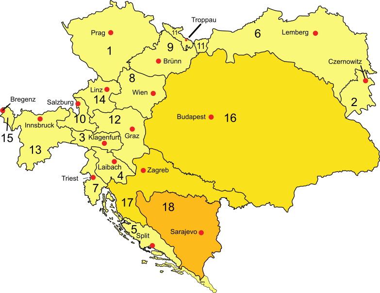
| ۲۳:۱۲, ۲۴ مئی ۲۰۱۱ |  | ۷۸۳ × ۶۰۵ (۵۷۲ کلوبائٹ) | Furfur | {{Information |Description={{de|<u>Österreich-Ungarn 1910</u>: * Cisleithanien: 1. Böhmen, 2. Bukowina, 3. Kärnten, 4. Krain, 5. Dalmatien, 6. Galizien, 7. Küstenland, 8. Österreich unter der Enns, 9. Mähren, 10. Salzburg, 11. Schlesien, 12. Steierm |
فائل دی ورتوں
تھلے دتے گئے 1 صفحے اس فائل نال جُڑدے نیں
فائل ویاپک ورتوں
ایہہ دوجے وکیاں ایس فائل نوں ورتدے نیں –
- ar.wikipedia.org تے ورتوں
- bg.wikipedia.org تے ورتوں
- bs.wikipedia.org تے ورتوں
- cs.wikipedia.org تے ورتوں
- de.wikipedia.org تے ورتوں
- Österreichisches Deutsch
- Krain
- Istrien
- Österreichisches Küstenland
- Geschichte Ungarns
- Länder der ungarischen Krone
- Kronland (Österreich)
- Geschichte der Steiermark
- Kroatien in der Donaumonarchie
- Österreich-Ungarn
- Kroatisches Küstenland
- Geschichte des Landes Salzburg
- Königreich Dalmatien
- Frano Supilo
- Geschichte Oberösterreichs
- Landtag (Österreich-Ungarn)
- Wikipedia Diskussion:Hauptseite/Artikel des Tages/Archiv/Vorschläge/2011/1
- Landeschef (Österreich-Ungarn)
- Benutzer:Reimmichl-212/Archiv 4
- dsb.wikipedia.org تے ورتوں
- en.wikipedia.org تے ورتوں
- fr.wikipedia.org تے ورتوں
- he.wikipedia.org تے ورتوں
- hu.wikipedia.org تے ورتوں
- ja.wikipedia.org تے ورتوں
- lb.wikipedia.org تے ورتوں
- ro.wikipedia.org تے ورتوں
- ru.wikipedia.org تے ورتوں
- sl.wikipedia.org تے ورتوں
- sv.wikipedia.org تے ورتوں
- uk.wikipedia.org تے ورتوں
- ur.wikipedia.org تے ورتوں
ایس فائل دا ویکھو ہور جگت ورتن .