فائل:Meghalaya COVID-19.svg

Size of this PNG preview of this SVG file: ۸۰۰ × ۴۳۰ پکسلز. دوجے ریزولوشنز: ۳۲۰ × ۱۷۲ پکسلز | ۶۴۰ × ۳۴۴ پکسلز | ۱,۰۲۴ × ۵۵۱ پکسلز | ۱,۲۸۰ × ۶۸۸ پکسلز | ۲,۵۶۰ × ۱,۳۷۷ پکسلز | ۸۰۷ × ۴۳۴ پکسلز ۔
اصل فائل (ایس وی جی فائل، پکسل:۸۰۷ × ۴۳۴، فائل سائز: ۱۵۷ کلوبائٹ)
خلاصہ
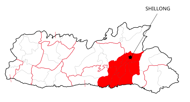
| تفصیل | This file shows the districts of Meghalaya affected by COVID-19. |
| تریخ | |
| سروت | Meghalaya 2012.svg |
| لکھاری | Nilabh |
| دوجے ورژن |
[]
|


لائسنس –
میں، اس کم دے کاپیرائٹ دا مالک، اس کم نوں اس لائسنس دے مطابق چھاپدا واں:
This file is licensed under the Creative Commons Attribution-Share Alike 4.0 International license.
- تہانوں کھلھ اے:
- حصہ کرنا – کاپی، ونڈنا تے کم بھیجنا
- فیر رلانا – کم نوں فٹ کرنا
- تھلے دتیاں شرطاں نال:
- کس دے ناں – تسیں لازمی ایس کم دے بناں والے بارے دسو جنج اونے آکھیا اے یا جنج لسنس چ آکھیا گیا ہے۔
- اکو جہا شئیر کرو۔ – اگر تسیں بدلدے یا ایس کم تے بناندے تے بنن والے کم نوں اینج دے لسنس نال ای ونڈو گے۔

|
کاپی کرن، ونڈن تے بدلن دی ایس ڈوکومنٹ لئی اجازت دتی جاندی اے ایہناں GNU Free Documentation License, Version 1.2 شرطاں نال یا مگروں کسے وی چھپے ورین Free Software Foundation توں بنا کسے انویرینٹ سیکشن دے، ناں فرنٹ کور لکھت تے ناں بیک کور لکھت دے۔ لسنس دی اک کاپی سیکشن وچ ہیگی اے جہدا ناں اے GNU Free Documentation License۔ |
تسیں اپنی مرضی دا لائسنس چݨ سکدے اوہ۔
فائل دی تریخ
فائل نو اس ویلے دی حالت وچ ویکھن واسطے تاریخ/ویلے تے کلک کرو۔
| تریخ تے ویلہ | نکی مورت | پاسے | ورتن والا | تیپّݨی کرو | |
|---|---|---|---|---|---|
| موجودہ | ۱۷:۴۱, ۱۳ مئی ۲۰۲۰ | | ۸۰۷ × ۴۳۴ (۱۵۷ کلوبائٹ) | Nilabh Shivam 333 | {{Information |description={{en|1=Districts with confirmed cases in the state of meghalaya, '''as of 12 May 2020'''.}} {{legend|#FF6347|10+ confirmed cases reported}} [https://web.archive.org/web/20040606141014/www.censusindia.net/results/2001maps/assam01.html]. Note: * This map does not show the newer districts that were created after 2014. * The new districts are Chirag, Baksa, Odalguri and Kamrup Metropolitan |Source={{Derived from|Meghalaya 2012.svg|display=50}} |Date=2020-05-13 18:34 (U... |
| ۲۳:۳۱, ۴ اپریل ۲۰۲۰ |  | ۶۳۱ × ۵۳۰ (۳۴۸ کلوبائٹ) | Firos ak | == {{int:filedesc}} == {{Information |Description={{en|1=This file shows the districts of en:Assam as of 2001. The map is based on a free hand trace of [https://web.archive.org/web/20040606141014/www.censusindia.net/results/2001maps/assam01.html]. Note: * This map does not show the newer districts that were created after 2001. * The new districts are Chirag, Baksa, Odalguri and Kamrup Metropolitan}} |Source={{Derived from|Assam-districts-2001.svg|display=50}} |Date=2020-04-04 18:31 (UT... | |
| ۰۴:۲۷, ۲۰ اگست ۲۰۱۱ |  | ۶۳۱ × ۵۳۰ (۲۱۱ کلوبائٹ) | Chaipau | Corrected the following districts: Nalbari, Barpeta, Sivasagar, Tinsukia | |
| ۱۶:۰۲, ۵ اپریل ۲۰۰۹ |  | ۶۳۱ × ۵۳۰ (۱۶۵ کلوبائٹ) | Chaipau | The image is cropped to exclude empty spaces. | |
| ۰۶:۱۴, ۵ اپریل ۲۰۰۹ |  | ۷۴۴ × ۱,۰۵۲ (۱۶۵ کلوبائٹ) | Chaipau | {{Information |Description={{en|1=This file shows the districts of en:Assam as of 2001. The map is based on a free hand trace of [http://web.archive.org/web/20040606141014/www.censusindia.net/results/2001maps/assam01.html]. Note: * This map does not |
فائل دی ورتوں
تھلے دتے گئے 27 صفحے اس فائل نال جُڑدے نیں
- ضلع اڈلگری
- ضلع بارپیٹا
- ضلع بونگائیگان
- ضلع بکسا
- ضلع جورہٹ
- ضلع درنگ
- ضلع دھیماجی
- ضلع سبساگر
- ضلع سونیتپور
- ضلع لکھیمپور
- ضلع ماریگون
- ضلع ناگون
- ضلع نلباری
- ضلع ٹنسوکیا
- ضلع چیرنگ
- ضلع ڈبروگڑھ
- ضلع ڈھبری
- ضلع ڈیما ہساو
- ضلع کاچڑ
- ضلع کربی انگلونگ
- ضلع کریم گنج
- ضلع کمرپ
- ضلع کمرپ میٹروپولیٹن
- ضلع کوکراجھر
- ضلع گولاگھٹ
- ضلع گولپاڑا
- ضلع ہائیلاکنڈی
فائل ویاپک ورتوں
ایہہ دوجے وکیاں ایس فائل نوں ورتدے نیں –
- awa.wikipedia.org تے ورتوں
- ca.wikipedia.org تے ورتوں
- eu.wikipedia.org تے ورتوں
- hi.wikipedia.org تے ورتوں
- असम
- दरंग जिला
- बंगाईगाँव जिला
- नलबाड़ी जिला
- जोरहाट जिला
- कार्बी आंगलोंग जिला
- कामरूप जिला
- कोकराझार जिला
- बरपेटा जिला
- डिब्रूगढ़ जिला
- धेमाजी जिला
- धुबरी जिला
- तिनसुकिया जिला
- गोवालपारा जिला
- लखीमपुर जिला
- भारत के ज़िले
- डिमा हासाओ जिला
- करीमगंज जिला
- गोलाघाट जिला
- नगाँव जिला
- मरिगाँव जिला
- शिवसागर जिला
- शोणितपुर जिला
- हाईलाकांदी जिला
- काछार जिला
- चिरांग जिला
- बाक्सा जिला
- उदलगुड़ी जिला
- कामरूप महानगर जिला
- विश्वनाथ जिला
- होजाई जिला
- चराईदेव जिला
- माजुली जिला
- kk.wikipedia.org تے ورتوں
- mai.wikipedia.org تے ورتوں
ایس فائل دا ویکھو ہور جگت ورتن .