فائل:Arabia 1914.png
ایس وکھالے دا ناپ: ۷۱۳ × ۶۰۰ پکسلز۔ دوجے ریزولوشنز: ۲۸۵ × ۲۴۰ پکسلز | ۵۷۱ × ۴۸۰ پکسلز | ۹۷۶ × ۸۲۱ پکسلز ۔
اصل فائل (۹۷۶ × ۸۲۱ پکسلز, فائل حجم: ۱۱۱ کلوبائٹ, MIME type: image/png)
خلاصہ
| تفصیل |
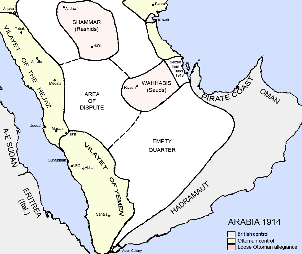
English: Political borders of the Arabian Peninsula in 1914. Source: Collapse of Empire: Ottoman Turks and the Arabs in the First World War, itself from King Husain and the Kingdom of Hejaz By Randall Baker . |
| تریخ | |
| سروت | آپݨا کم |
| لکھاری | Underlying lk |
| دوجے ورژن |
.png) .png)  |

|
This historical map image could be re-created using vector graphics as an SVG file. This has several advantages; see Commons:Media for cleanup for more information. If an SVG form of this image is available, please upload it and afterwards replace this template with
{{vector version available|new image name}}.
It is recommended to name the SVG file “Arabia 1914.svg”—then the template Vector version available (or Vva) does not need the new image name parameter. |
لائسنس –
میں، اس کم دے کاپیرائٹ دا مالک، اس کم نوں اس لائسنس دے مطابق چھاپدا واں:
ایس فائل نوں کریٹو کامنز Attribution 2.5 پولینڈ لائسنس دتا گیا.
- تہانوں کھلھ اے:
- حصہ کرنا – کاپی، ونڈنا تے کم بھیجنا
- فیر رلانا – کم نوں فٹ کرنا
- تھلے دتیاں شرطاں نال:
- کس دے ناں – تسیں لازمی ایس کم دے بناں والے بارے دسو جنج اونے آکھیا اے یا جنج لسنس چ آکھیا گیا ہے۔
- اکو جہا شئیر کرو۔ – اگر تسیں بدلدے یا ایس کم تے بناندے تے بنن والے کم نوں اینج دے لسنس نال ای ونڈو گے۔
فائل دی تریخ
فائل نو اس ویلے دی حالت وچ ویکھن واسطے تاریخ/ویلے تے کلک کرو۔
| تریخ تے ویلہ | نکی مورت | پاسے | ورتن والا | تیپّݨی کرو | |
|---|---|---|---|---|---|
| موجودہ | ۰۹:۳۴, ۲۶ فروری ۲۰۲۴ | | ۹۷۶ × ۸۲۱ (۱۱۱ کلوبائٹ) | Abo Yemen | fixed map legend as it used to cause confusion that the region in grey is hadhramout |
| ۱۴:۵۲, ۲۲ مئی ۲۰۱۳ |  | ۹۷۶ × ۸۲۱ (۱۵۴ کلوبائٹ) | Underlying lk | User created page with UploadWizard |
فائل دی ورتوں
تھلے دتے گئے 1 صفحے اس فائل نال جُڑدے نیں
فائل ویاپک ورتوں
ایہہ دوجے وکیاں ایس فائل نوں ورتدے نیں –
- ar.wikipedia.org تے ورتوں
- azb.wikipedia.org تے ورتوں
- az.wikipedia.org تے ورتوں
- bn.wikipedia.org تے ورتوں
- cs.wikipedia.org تے ورتوں
- da.wikipedia.org تے ورتوں
- de.wikipedia.org تے ورتوں
- en.wikipedia.org تے ورتوں
- fr.wikipedia.org تے ورتوں
- gl.wikipedia.org تے ورتوں
- gom.wikipedia.org تے ورتوں
- he.wikipedia.org تے ورتوں
- hu.wikipedia.org تے ورتوں
- hy.wikipedia.org تے ورتوں
- id.wikipedia.org تے ورتوں
- it.wikipedia.org تے ورتوں
- ja.wikipedia.org تے ورتوں
ایس فائل دا ویکھو ہور جگت ورتن .