فائل:Umayyad750ADloc-ar.png

ایس وکھالے دا ناپ: ۸۰۰ × ۴۸۷ پکسلز۔ دوجے ریزولوشنز: ۳۲۰ × ۱۹۵ پکسلز | ۶۴۰ × ۳۹۰ پکسلز | ۱,۰۲۴ × ۶۲۴ پکسلز | ۱,۴۸۱ × ۹۰۲ پکسلز ۔
اصل فائل (۱,۴۸۱ × ۹۰۲ پکسلز, فائل حجم: ۴۶ کلوبائٹ, MIME type: image/png)
خلاصہ
| تفصیل |
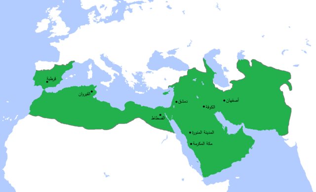
العربية: خارطة تُظهر المساحة التي امتدَّت عليها الدولة الأُمويَّة في أقصى اتساعها وذُروة قوَّتها، حوالي سنة 750م. (الرسم مبني بشكلٍ جُزئيّ على كتاب "أطلس تاريخ العالم" (2007) - العالم ما بين سنتيّ 500 و750م، الخارطة.) |
| تریخ | (UTC) |
| سروت |
This file was derived from: Umayyad750ADloc.png: |
| لکھاری |
|
| This is a retouched picture, which means that it has been digitally altered from its original version. Modifications: Translated to Arabic - عُرِّبت. The original can be viewed here: Umayyad750ADloc.png:
|
لائسنس –
میں، اس کم دے کاپیرائٹ دا مالک، اس کم نوں اس لائسنس دے مطابق چھاپدا واں:
ایس فائل نوں کریٹو کامنز Attribution 3.0 انپورٹڈ لائسنس دتا گیا.
- تہانوں کھلھ اے:
- حصہ کرنا – کاپی، ونڈنا تے کم بھیجنا
- فیر رلانا – کم نوں فٹ کرنا
- تھلے دتیاں شرطاں نال:
- کس دے ناں – تسیں لازمی ایس کم دے بناں والے بارے دسو جنج اونے آکھیا اے یا جنج لسنس چ آکھیا گیا ہے۔
پہلا اپلوڈ دا ریکارڈ
This image is a derivative work of the following images:
- File:Umayyad750ADloc.png licensed with Cc-by-3.0
- 2013-04-11T15:24:29Z HistoryofIran 1481x902 (30417 Bytes) {{subst:Upload marker added by en.wp UW}} {{Information |Description = {{en|Made the map more presice, the Umayyads never controlled Tabaristan because of the Dabuyid dynasty, but the Abbasids did that later.}} |Source = http
- 2013-04-10T15:55:41Z Khateeb88 1481x902 (38391 Bytes) Added the major cities of the Umayyad Caliphate: Damascus, Kufa, Isfahan, Mecca, Medina, Fustat, Kairouan, and Cordoba.
- 2013-04-10T15:54:28Z Khateeb88 1481x902 (38391 Bytes) Added the major cities of the Umayyad Caliphate: Damascus, Kufa, Isfahan, Mecca, Medina, Fustat, Kairouan, and Cordoba.
- 2009-04-22T16:17:51Z Gabagool 1481x902 (51495 Bytes) some corrections..
- 2009-04-20T16:10:54Z Gabagool 1481x902 (51573 Bytes) {{Information |Description={{en|1=Locator map for the Umayyad Caliphate at its greatest extent, c. AD 750. (Partially based on ''Atlas of World History'' (2007) - World 500-750, map.)}} |Source=Own work by uploader |Author=[
Uploaded with derivativeFX
فائل دی تریخ
فائل نو اس ویلے دی حالت وچ ویکھن واسطے تاریخ/ویلے تے کلک کرو۔
| تریخ تے ویلہ | نکی مورت | پاسے | ورتن والا | تیپّݨی کرو | |
|---|---|---|---|---|---|
| موجودہ | ۱۸:۲۳, ۱۶ نومبر ۲۰۱۳ | | ۱,۴۸۱ × ۹۰۲ (۴۶ کلوبائٹ) | باسم | {{Information |Description ={{en|1=map}} |Source =derevative |Author =me |Date =2013 |Permission = |other_versions = }} |
فائل دی ورتوں
تھلے دتے گئے 1 صفحے اس فائل نال جُڑدے نیں
فائل ویاپک ورتوں
ایہہ دوجے وکیاں ایس فائل نوں ورتدے نیں –
- ar.wikipedia.org تے ورتوں
- العراق
- الإسلام
- عمر بن عبد العزيز
- بوابة:التاريخ
- البصرة
- ولاية الجزائر
- القوقاز
- أبو العباس السفاح
- بوابة:التاريخ الإسلامي
- قائمة الخلفاء
- ويكيبيديا:في هذا اليوم/23 أبريل
- طريف بن مالك
- عمر بن هبيرة
- بوابة:الإمبراطورية الروسية
- بوابة:الإمبراطورية الروسية/بوابات شقيقة
- ويكيبيديا:مقالة الصفحة الرئيسية المختارة/197
- الممالك في إفريقيا قبل الاستعمار
- سعيد بن عمرو الحرشي
- بوابة:مكة/مقالة مختارة/أرشيف
- بوابة:مكة/مقالة مختارة/9
- بوابة:الأديان/تاريخ ديني/1
- بوابة:الأديان/تاريخ ديني
- قائمة السلالات الحاكمة الإسلامية
- بوابة:الإسلام/دولة مختارة
- بوابة:الإسلام/دولة مختارة/2
- بوابة:التاريخ/فقرات منوعة/أرشيف
- بوابة:التاريخ/فقرات منوعة/7
- بوابة:التاريخ الإسلامي/دولة مختارة/9
- بوابة:التاريخ الإسلامي/دولة مختارة/أرشيف
- بوابة:الإمبراطورية الألمانية
- بوابة:الإمبراطورية الألمانية/بوابات شقيقة
- بوابة:إمبراطورية اليابان
- بوابة:إمبراطورية اليابان/بوابات شقيقة
- بوابة:الخلافة الراشدة
- بوابة:الدولة الأموية
- بوابة:الدولة الأموية/واجهة
- مستخدم:عبد المؤمن/مصور/تاريخ إسلامي
- بوابة:الإمبراطورية الفرنسية الأولى/بوابات شقيقة
- بوابة:الإمبراطورية الفرنسية الأولى
- بوابة:الإمبراطورية النمساوية/بوابات شقيقة
- بوابة:الإمبراطورية النمساوية
- بوابة:العالم الإسلامي/مقالة مختارة/أرشيف
- بوابة:العالم الإسلامي/مقالة مختارة/1
- بوابة:العالم الإسلامي
- قالب:مواضيع متعلقة 3
- قالب:مواضيع متعلقة 3/شرح
- بوابة:العالم الإسلامي/تاريخ
- بوابة:العالم الإسلامي/مواضيع متعلقة
- بوابة:الإمبراطورية البريطانية
- بوابة:الإمبراطورية البريطانية/بوابات شقيقة
ایس فائل دا ویکھو ہور جگت ورتن .