فائل:Topographic map of Tenerife-en.svg

Size of this PNG preview of this SVG file: ۸۰۰ × ۵۹۲ پکسلز. دوجے ریزولوشنز: ۳۲۰ × ۲۳۷ پکسلز | ۶۴۰ × ۴۷۳ پکسلز | ۱,۰۲۴ × ۷۵۷ پکسلز | ۱,۲۸۰ × ۹۴۷ پکسلز | ۲,۵۶۰ × ۱,۸۹۴ پکسلز | ۱,۰۴۵ × ۷۷۳ پکسلز ۔
اصل فائل (ایس وی جی فائل، پکسل:۱,۰۴۵ × ۷۷۳، فائل سائز: ۵۰۵ کلوبائٹ)
خلاصہ
| تفصیل |
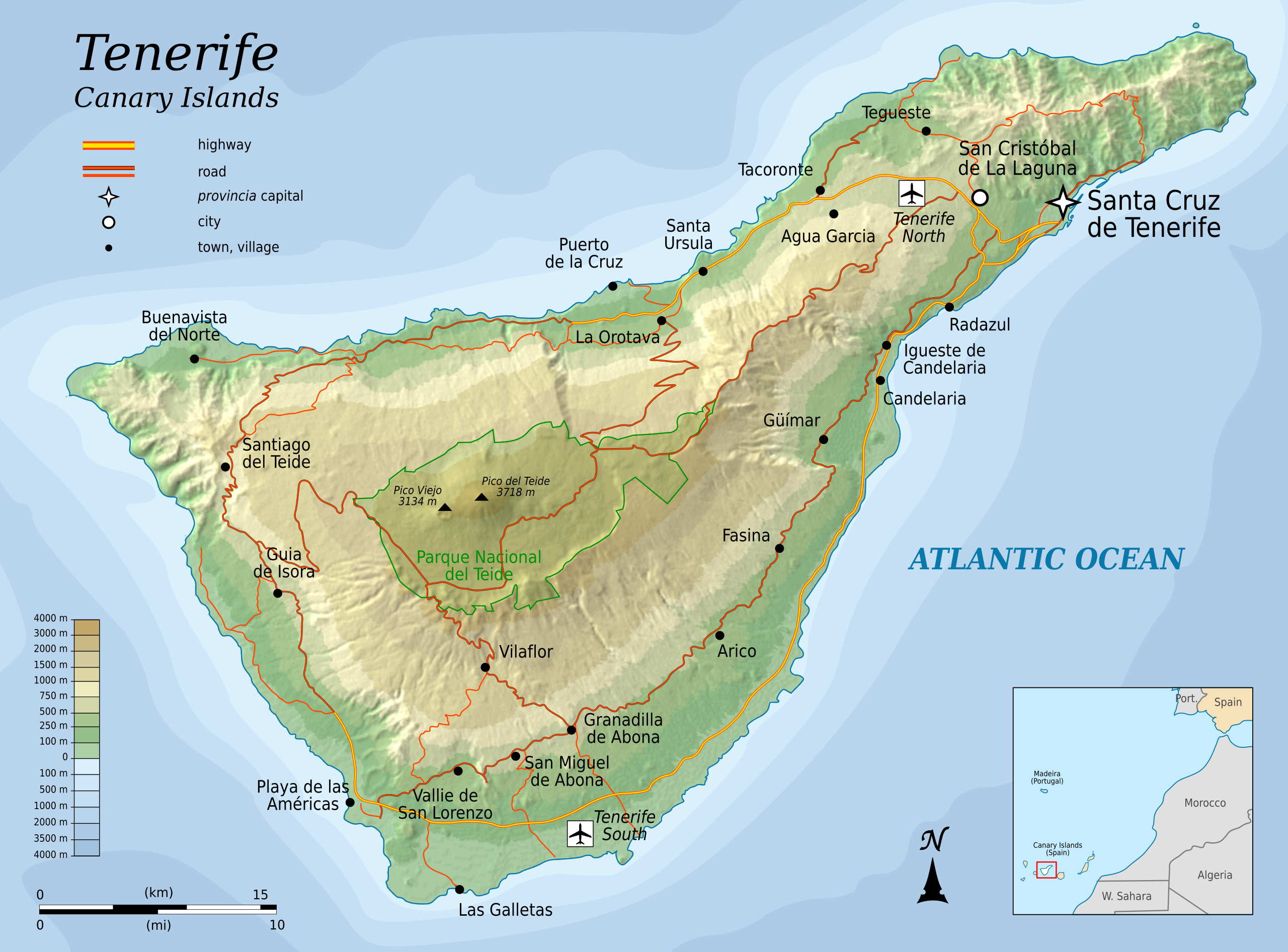
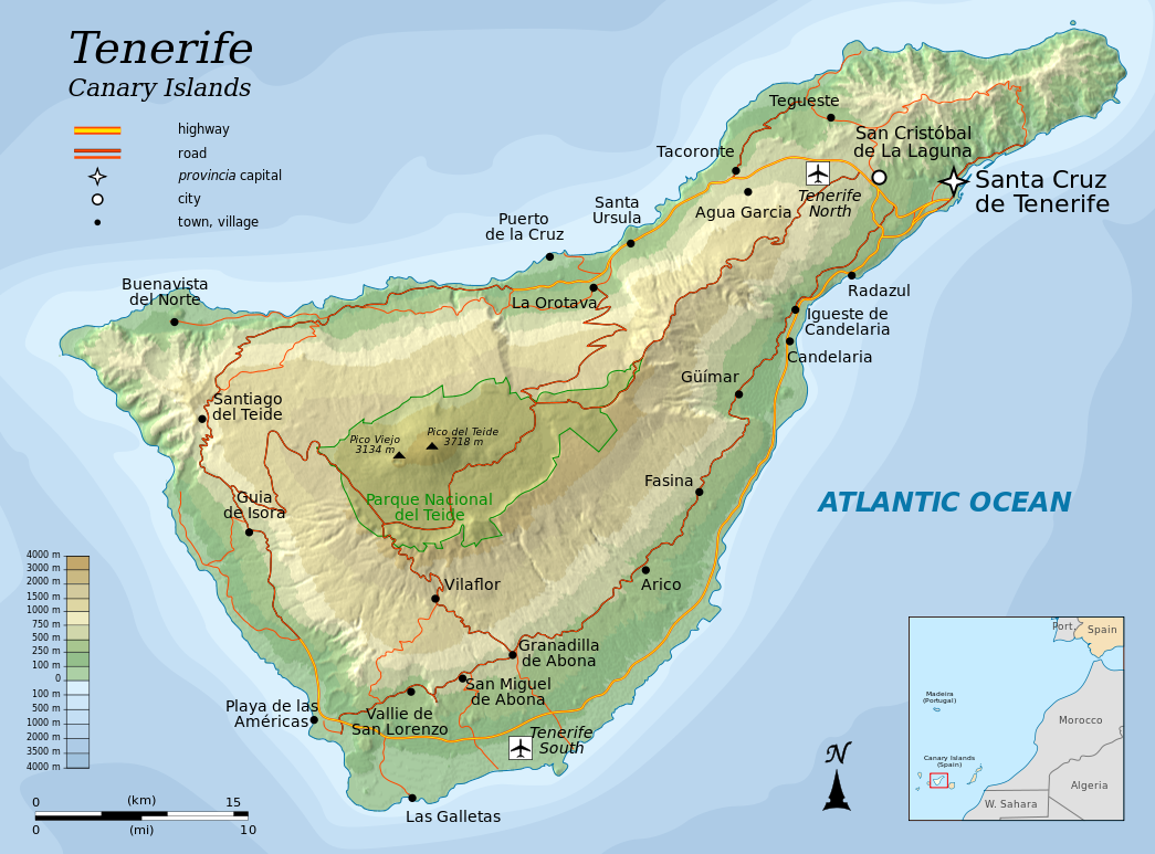
English: Topographic map of Tenerife, an island of the Canary Islands of Spain. |
| تریخ | |
| سروت |
Self-made in Inkscape.
|
| لکھاری | Oona Räisänen (Mysid) |
| دوجے ورژن |
|


|
This SVG file contains embedded text that can be translated into your language, using any capable SVG editor, text editor or the SVG Translate tool. For more information see: About translating SVG files. |
This W3C-invalid vector image was created with Inkscape .
لائسنس –
میں، اس کم دے کاپیرائٹ دا مالک، اس کم نوں اس لائسنس دے مطابق چھاپدا واں:
ایس فائل نوں کریٹو کامنز Attribution 2.5 پولینڈ لائسنس دتا گیا.
- تہانوں کھلھ اے:
- حصہ کرنا – کاپی، ونڈنا تے کم بھیجنا
- فیر رلانا – کم نوں فٹ کرنا
- تھلے دتیاں شرطاں نال:
- کس دے ناں – تسیں لازمی ایس کم دے بناں والے بارے دسو جنج اونے آکھیا اے یا جنج لسنس چ آکھیا گیا ہے۔
- اکو جہا شئیر کرو۔ – اگر تسیں بدلدے یا ایس کم تے بناندے تے بنن والے کم نوں اینج دے لسنس نال ای ونڈو گے۔

|
کاپی کرن، ونڈن تے بدلن دی ایس ڈوکومنٹ لئی اجازت دتی جاندی اے ایہناں GNU Free Documentation License, Version 1.2 شرطاں نال یا مگروں کسے وی چھپے ورین Free Software Foundation توں بنا کسے انویرینٹ سیکشن دے، ناں فرنٹ کور لکھت تے ناں بیک کور لکھت دے۔ لسنس دی اک کاپی سیکشن وچ ہیگی اے جہدا ناں اے GNU Free Documentation License۔ |
تسیں اپنی مرضی دا لائسنس چݨ سکدے اوہ۔
فائل دی تریخ
فائل نو اس ویلے دی حالت وچ ویکھن واسطے تاریخ/ویلے تے کلک کرو۔
| تریخ تے ویلہ | نکی مورت | پاسے | ورتن والا | تیپّݨی کرو | |
|---|---|---|---|---|---|
| موجودہ | ۱۱:۲۵, ۶ اگست ۲۰۱۰ | | ۱,۰۴۵ × ۷۷۳ (۵۰۵ کلوبائٹ) | Mysid | more roads + north reference |
| ۰۲:۴۵, ۶ اگست ۲۰۱۰ |  | ۱,۰۴۵ × ۷۷۳ (۴۶۶ کلوبائٹ) | Mysid | add northern airport | |
| ۰۱:۳۰, ۶ اگست ۲۰۱۰ |  | ۱,۰۴۵ × ۷۷۳ (۴۶۳ کلوبائٹ) | Mysid | fonts | |
| ۰۱:۲۶, ۶ اگست ۲۰۱۰ |  | ۱,۰۴۵ × ۷۷۳ (۴۶۳ کلوبائٹ) | Mysid | {{Information |Description={{en|1=Topographic map of Tenerife, and island of the Canary Islands of Spain.}} |Source=Self-made in Inkscape. |Author=Mysid |Date=2010-08-05 |Permission= |other_versions= }} {{translation possib |
فائل دی ورتوں
تھلے دتے گئے 1 صفحے اس فائل نال جُڑدے نیں
فائل ویاپک ورتوں
ایہہ دوجے وکیاں ایس فائل نوں ورتدے نیں –
- cs.wikipedia.org تے ورتوں
- en.wikipedia.org تے ورتوں
- fi.wikipedia.org تے ورتوں
- fr.wikipedia.org تے ورتوں
- hr.wikipedia.org تے ورتوں
- hu.wikipedia.org تے ورتوں
- ko.wikipedia.org تے ورتوں
- mr.wikipedia.org تے ورتوں
- nl.wikipedia.org تے ورتوں
- ru.wikipedia.org تے ورتوں
- sl.wikipedia.org تے ورتوں
- tr.wikipedia.org تے ورتوں
- zh.wikipedia.org تے ورتوں