فائل:Plan de Paris 1705 BNF07710700.png
ایس وکھالے دا ناپ: ۷۳۹ × ۶۰۰ پکسلز۔ دوجے ریزولوشنز: ۲۹۶ × ۲۴۰ پکسلز | ۵۹۱ × ۴۸۰ پکسلز | ۹۴۶ × ۷۶۸ پکسلز | ۱,۲۶۱ × ۱,۰۲۴ پکسلز | ۲,۵۲۳ × ۲,۰۴۸ پکسلز | ۳,۸۹۰ × ۳,۱۵۸ پکسلز ۔
اصل فائل (۳,۸۹۰ × ۳,۱۵۸ پکسلز, فائل حجم: ۱۵.۸۹ میگابائٹ, MIME type: image/png)
خلاصہ
| لکھاری |
|
||||||||||||||||||||
| تفصیل |
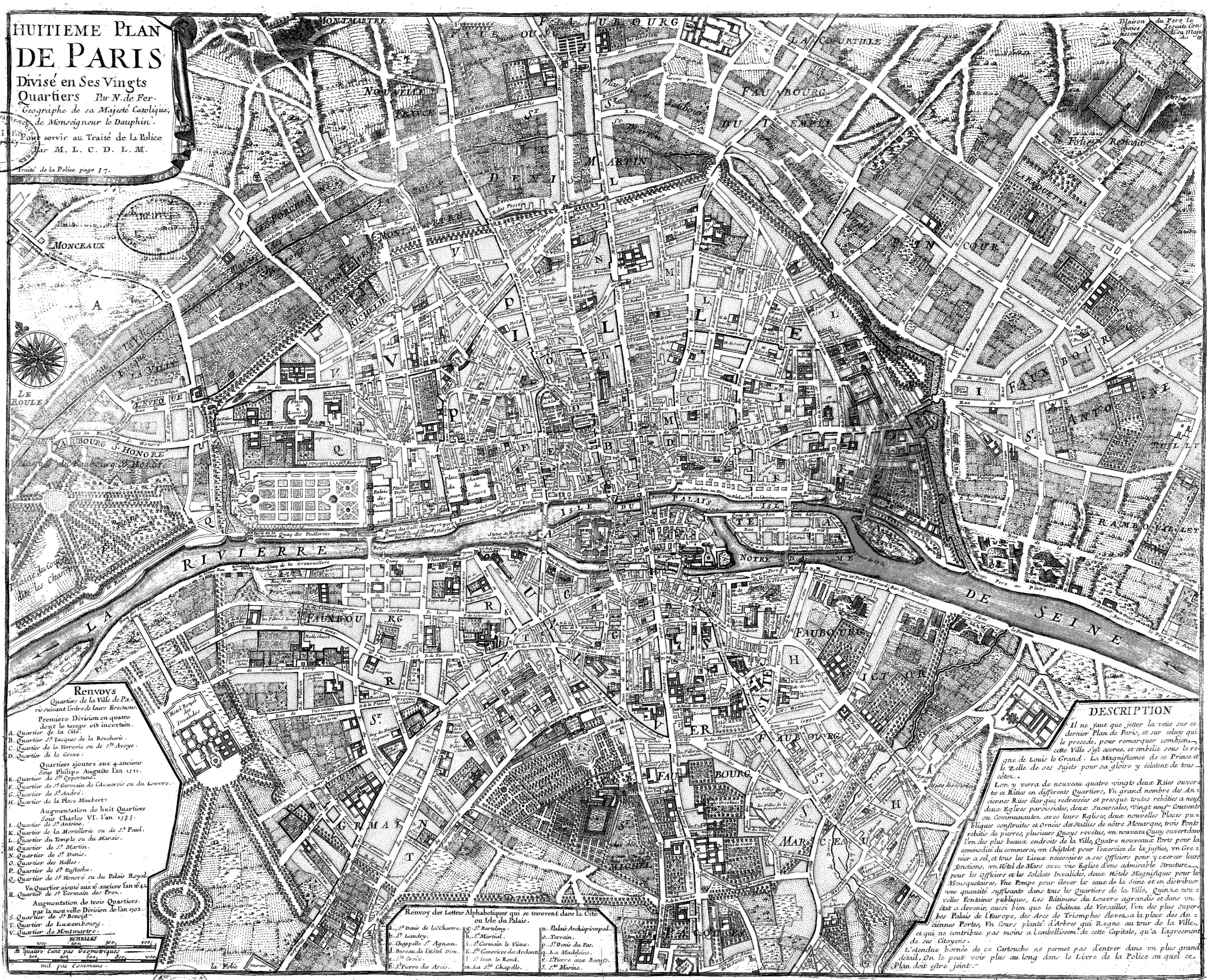
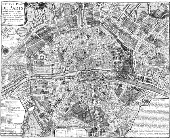
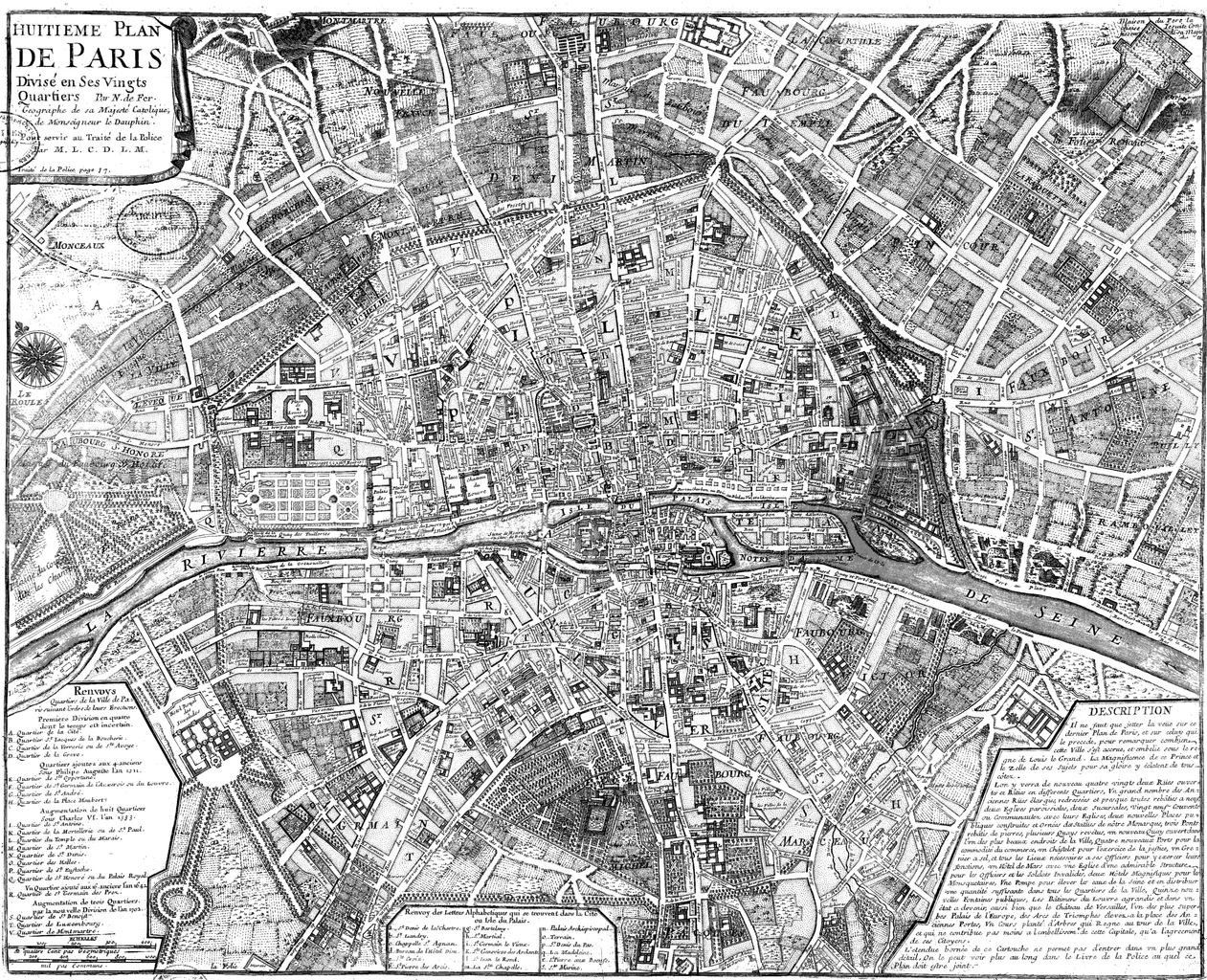
Français : Huitième plan de Paris divisé en ses vingts quartiers [Image fixe numérisée] / par N. de Fer Publication : Paris, 1705 Description matérielle : 1 carte ; 44,5 x 54,5 cm Collection : Collection d'Anville ; 00808 Note(s) : Cote : Ge DD 2987 (808) BNF Richelieu Cartes et Plans Reprod. 85 C 125661 ; Reprod. Sc 87/660 . - Légende et description en marge gauche et droite. Carte "pour servir au traité de la Police par M.L.C.D.L.M. Traité de la Police p. 87" Sujet(s) : Paris (France) -- Quartiers anciens Notice n° : FRBNF38638263 |
||||||||||||||||||||
| تریخ | ۱۷۰۵ | ||||||||||||||||||||
| ذریعہ/فوٹوگرافر | Gallica | ||||||||||||||||||||
| دوجے ورژن |
|
||||||||||||||||||||


| Open this image as an overlay in Google Earth (Google Maps, Bing) | (Help|Source) |
لائسنس –
|
This work is in the public domain in its country of origin and other countries and areas where the copyright term is the author's life plus 100 years or fewer. | |
| ایہ فائل دے بارے چ دس اے جے اے کاپی حف دیاں روکاں توں کھلی اے تے نالدے رلدے حقاں توں وی۔ | |
| Previous public domain rationale, no longer applicable | ||
|---|---|---|
|
فائل دی تریخ
فائل نو اس ویلے دی حالت وچ ویکھن واسطے تاریخ/ویلے تے کلک کرو۔
| تریخ تے ویلہ | نکی مورت | پاسے | ورتن والا | تیپّݨی کرو | |
|---|---|---|---|---|---|
| موجودہ | ۱۴:۲۰, ۹ جون ۲۰۰۸ | | ۳,۸۹۰ × ۳,۱۵۸ (۱۵.۸۹ میگابائٹ) | Yann | reduce to below 12.5 Mpx, otherwise it will never display with Wikimedia limits. Nothing is lost (see history for the complete version, or the reference link) |
| ۰۱:۴۷, ۲۳ ستمبر ۲۰۰۵ |  | ۴,۱۸۳ × ۳,۳۹۶ (۲.۷۶ میگابائٹ) | David.Monniaux | Map of Paris in 1705 Type : image fixe, monographie Titre(s) : Huitième plan de Paris divisé en ses vingts quartiers [Image fixe numérisée] / par N. de Fer Publication : Paris, 1705 Description matérielle : 1 carte ; 44,5 x 54,5 cm Colle |
فائل دی ورتوں
تھلے دتے گئے 1 صفحے اس فائل نال جُڑدے نیں
فائل ویاپک ورتوں
ایہہ دوجے وکیاں ایس فائل نوں ورتدے نیں –
- ar.wikipedia.org تے ورتوں
- en.wikipedia.org تے ورتوں
- fr.wikipedia.org تے ورتوں
- gl.wikipedia.org تے ورتوں
- he.wikipedia.org تے ورتوں
- hu.wikipedia.org تے ورتوں
- it.wikipedia.org تے ورتوں
- ja.wikipedia.org تے ورتوں
- ko.wikipedia.org تے ورتوں
- nl.wikipedia.org تے ورتوں
- pl.wikipedia.org تے ورتوں
- ur.wikipedia.org تے ورتوں